1915-1963
From - To Kunene from the Cape: Future Pasts literature review timelining, compiled by Sian Sullivan for Future Pasts
Last edited 20/02/2023
© This review work is licensed under the Creative Commons Attribution-NonCommercial 4.0 International License
Citation: Sullivan, S. 2022 To Kunene from the Cape: Future Pasts literature review timelining, 1915-1963.
Online: https://www.futurepasts.net/1915-1963
This ‘timeline’ follows from 1884-1914.
Notes
1. Places marked on the online map accompanying this historical sequence of references are coloured in green in the text below. They can be found on the google map by searching on their name.
2. Follow these links for full references and a list of abbreviations.
3. A double-asterix [**] is a marker for myself that there is something to be checked or added at this point in the text.
4. An introduction to this chronological sequence of references is here.
5. Information and connections are welcome! Please email futurepastscontact@gmail.com
1915
Famine in this year again reduces the Humbe populaton in southern Angola[1].
The territory of the Ombanja [see 1904-07] in southern Angola is ‘finally conquered … by the Portuguese, and their capital Ondjiva, now Vila Pereira d’Eça, was burnt down[2].
On 31 January the Afrikaner rebellion supported by German SWA (see 1914) comes to an end with a capitulation signed in the vicinity of Upington[3]. In this month, four South African PoWs escape from a German camp at Franzfontein survive after finding water at Cape Cross, before making their way to Swakopmund[4].
In April, and against a backdrop of negotiations with Smuts for more autonomy, the Rehoboth Basters rise-up against German rule, killing several soldiers and farmers and fighting a ‘bloody battle’ at Sam-!Khubis, south-west of Rehoboth, still commemorated today[5]. The rebellion is quelled - Reported in the following terms - War breaks out between Rehoboth Basters and Germans[6], and Dax** (see above) whilst working at the Blue Hotel in Rehoboth happens upon a letter talking about an ‘extermination order against the enemies of the German Imperial Government’ and so tips off ‘Baster friend Koos Samuel alias Petisie and Jakobus Beukes’, such that ‘within no time the whole Rehoboth and surrounding areas was alerted to the real intention of the Baster-German Schutzvertrag’ followed by a war in which ‘thousands of natives were killed, raped and brutalised, after the Damara, Nama, and the Baster fighters were already disarmed’[7].
Windhoek is taken by Union of South African troops on 12 May (following the blockading of Lüderitz, the landing of enemy forces in Walvis Bay and the taking of Swakopmund)[8]. Ending of German colonial rule follows the signing of a Surrender Treaty at Khorab near Otavi on 9th July[9] (signed by Governor Theodor Seitz and Lieutenant-Colonel Victor Franke on behalf of GSWA and General Louis Botha on behalf of the Union forces, with responsibility for execution by Brigadier H.T. Lukin[10]), and GSWA becomes British South West Africa following invasion led by the Boer generals Smuts and Louis Botha[11]. Three ‘home areas’ established under German rule are Okombahe (Damara), Rehoboth (Baster) and Berseba (Nama)[12].
Following the surrender, active German soldiers are interned at Aus (on railway line between Keetmanshoop and Lüderitz, the latter the port for shipments from Cape Town), as well as at a heightened security prisoner of war camp at Kanus (on the site of the 3rd Company of Colonial Troops[13]), with some officers of detained at Okanjande camp near Otjiwarongo (former base of the 10th Company of the German Colonial Troops[14])[15]. Paragraphs 3 and 8 of the Surrender Treaty stipulate ‘that all soldiers and noncommissioned officers of the active German troops, as well as members of the Territorial Police (“Landespolizei” - the former German South West Africa police force) were to be detained as prisoners of war until peace had been concluded in Europe and in other theatres of war’[16]. On 21 July, 797 German Prisoners of War (PoWs) were transported by rail from Otavi to Aus, the last train transporting PoWs leaving Tsumeb on 27 July, and 960 PoWs were also transported from Kimberley to Cape Town[17]. By mid-August 1,552 PoWs and around 600 officers and men of the South African Veterans Regiment (SAVR) had been brought to the camp at Aus[18]. Omburo South farm near Omaruru is ‘occupied by South African troops for some months’ along the resident German RMS mission farmer stays on to manage it[19].
On 22 July, Brigadier Lukin reports to Windhoek from Otavifontein that ‘a group of black soldiers who had fought under the German flag in Cameroon, had been brought to his headquarters in Grootfontein’, asking what should be done with them – the response from Colonel de Jager being that ‘they should be sent to Aus’, and thus 24 Cameroonian soldiers arrived there on 2 August[20]. They argued that they were political prisoners, having been sent to GSWA from Cameroon in 2010 under a five year forced labour sentence, having mutinied whilst in the German Cameroon army[21].
This year marks the formal colonisation of land and peoples north of the Red Line[22] under ‘a military administration run [until 1920] by the Union of South Africa’[23]. The revenue and expenditure for the year ending March 31st is estimated to balance at £2,081,157[24]. The ‘natural boundaries of the Union of South Africa are to be expanded northwards from the Orange River to Portuguese Angola, and westward from Bechuanaland to the Atlantic Ocean’, providing ‘the Botha Government, in Namaqualand and Damaraland, with more land for the “bijwohners,’ or poor white class’[25]. General Louis Botha thus declares on 26 July that ‘“[i]n German South West Africa homesteads are waiting for many a South African son’[26]. A contemporary British commentator remarks that ‘inter-tribal warfare is practically unknown [in South West Africa’, and ‘the danger of a native uprising is nil’[27] and states that:
[i]n order to colonise it is necessary to possess some sort of perception of the rights of humanity, and Germany has invariably committed the fatal error of misjudging humanity altogether. The lessons which must be mastered before a nation can control and govern a subject race she has systematically refused to learn, until her violations of treaties and her brutal treatment of the natives compelled the Hon. W. P. Schreiner to the conclusion that it would never be possible again for Germany and Britain to march side by side in the work of colonisation in Africa.[28]
The presence claimed of:
a force of ten thousand trained German soldiers, fully equipped with arms, ammunition stores, and military supplies sufficient to last the army for six years [with] five thousand troops and two years’ stores … concentrated within 150 miles of the Union border [is used to suggest] that Germany has been preparing to make trouble for the British in this part of the world on a thoroughly organized plan.[29]
Retreat and defeat of German forces opens the way for indigenous reconstruction and pastoral recovery (in terms of numbers of livestock rather than access to markets[30]), especially amongst Herero and Nama communities in southern and central Namibia[31]. For example, Edward Fredericks, second son of Joseph Fredericks (leader in Bethanie area from 1868-1893), returned to Bethanie following confinement in ‘Damaraland’[32]. Daniel Kariko and Michael Tjisiseta of Hereron chiefly lineages also return[33]. ‘Bushman hunting’ is banned by the incoming South African administration, and the first South African military magistrate in Grootfontein district writes of how ‘the Bushmen have all lost faith in the white man’s methods [of justice], more especially as their women were being constantly interfered with by both farmers and police’[34]. A contract labour system is instituted[35]. Abraham Morris, a close friend of Marengo’s, returns to Namibia from South Africa, later becoming a leader in the Bondelswarts uprising (see 1922)[36] and being an informant of Winifred Hoernlé’s.
The hunting / game ordinance of 1902 remains in force up to occupation of the territory by South African forces in 1915 in the context of World War 1, when EHL Gorges was appointed Governor of the Military Regime[37] (and was technically still in force until new Union of South Africa legislation of 1921.
Kwanyama king Mandume ya Ndemufayo moves his capital from Ondjiva in Angola to Oihole in Namibia, after failing to prevent Portuguese invasion of Kwanyama territory in Angola[38] under General Pereira de Eça, having received confirmation of protection by Major Pritchard on 2 September[39]. When colonial officials enter Owamboland they are offered hoarded ivory as tribute by King Martin ka Dikwa of Ondonga[40].
Vita Tom / Oorlog and commando take part in a battle of Mongwa against Mandume[41]; statement taken from Oorlog by Manning in Sesfontein in 1917 confirms that:
Before the big famine in Ovamboland (1915) Mandume had killed some Portuguese traders and later his headman KALOLA captured six cannons and five wagons from Portuguese escort going to KASIMA. An expedition got to MDNGWE where Mandume fell on the laager. For four days his army fired on the Portuguese troops and my people. I was hit through the side and show the wounds. (Through right side and through ribs. CNM.) I obtained permission to make a sortie with my men which I did and the Ovakuanyama fell back to ONDJIVA. We followed and found Mandume had burnt his great kraal at ONDJIVA and fled to Namakunde. Later I saw the English Officers who met the Portuguese at ONDJIVA.[42]
After German surrender Vita Tom leads some Himba and Herero ‘back into sparsely populated Kaokoland’, having accumulated herds through cattle raids of Kuvare, Ngumbi and Kwanyama peoples of southern Angola[43]. He leaves Angola ‘with a mixed group of Bushmen, Nama, Himba and Herero’, referred to collectively in colonial records, e.g. by Manning, as ‘Oorlamse men’, intending to return to Omaruru ‘and take up residence there with his matrilineal relatives who were closely related to the noble line of the Zeraua family’[44], although this did not transpire. Vita Tom and Muhona Katiti are ‘well armed with modern guns’ whereas ‘people further to the south were armed with old fashioned muzzle loading guns which had probably changed hands three or four times already before ending up in Kaokoland’[45].
The concession to the Kaokoland Land and Mining Company is nullified by the South African government (as martial law takes hold in the territory[46]) - ‘[o]nly four farms had been surveyed and sold and they were never occupied’[47]. Major Charles Manning is appointed Resident Commissioner of Ovamboland, from where he also treks to Kaoko[48].
A scout with the Union of SA invasion force in 1915 is later reported to have been a relative of Samuel Maherero (in exile in Botswana) and to have sought to organise the Herero-associated Truppenspieler movement (see below)[49].
Isaac Witbooi, son of Hendrik Witbooi, returns to Gibeon as one of a few survivors of deportees to the Cameroons under GSWA[50]. He appoints ‘lieutenants on white farms to send cases of offenders (mainly adulterers) to his court in Gibeon[51].
At this point, the ‘vitally important strategical point’ of Walvis Bay, from which hides and cattle (formerly ivory and ostrich feathers, but these are now depleted) are exported to the Cape, remains ‘an administrative dependency of the Cape, and it is politically held by England in trust for her future South African Empire, the consolidation of which has already begun’[52]. Lüderitzbucht in the south, expanding due to diamond discoveries, relies on water ‘brought in tanks from Cape Town or condensed on the spot’[53]. Calvert in describing Lüderitz and its economy in this year includes no mention of the earlier concentration camp located on Shark Island in Lüderitz bay[54].
1915-1920
Martial law is established under Union of South Africa rule, characterised by both liberalism and paternalism[55].
1915-1921
Major Charles N. Manning is Resident Commissioner for Owamboland, under the Union Native Affairs Dept.[56]. Following German rule, some greater justice is provided for in legal system and labour market and reform is accompanied by incidents of defiance associated with expectations of land restitution and enabling some reconstruction of identities and livelihoods[57].
In the mid- and late 1910s, immigration from Angola into Kaoko re-initiates raids and leads to the dislocation of many people, favouring ‘the beginnings of administrative policy’ and administrative ‘action in Kaoko by the South African administration’, as led by Manning[58].
ca. 1915-1947
In relation to ‘nature conservation’, these decades are characterised by Eugene Joubert as a period of ‘stagnation’,
during which time virtually no progress was made regarding conservation as a whole. Various Ordinances were proclaimed but enforcement in the vast area of SWA was virtually impossible, especially since no officials directly responsible for nature conservation existed.[59].
1916
The British pound gains in value[60]. The Easter Rising takes place on Easter Monday in Dublin, when the Irish Republican Brotherhood and Irish Volunteers (later Sinn Fein) rebelled against England[61].
The German Proclamation of 1907 (regarding game reserves) is repealed by Ordinance No. 1 of 1916 and amended to suit the new situation and to reconfirm the borders of the Game Reserve No. 2[62]. Proclamation 10 of 1916 is the first law in the territory to protect a plant, and protects Welwitschia mirabilis, especially in Game Reserve No. 3[63].
New colonial authority established and adopts the inner-Namibian border of the Red Line as the northern boundary of European settlement[64].
Hahn travels as Intelligence Officer to Kwanyama king Mandume’s residence in Oihole[65] from where the king increasingly defies the terms of South African ‘protection’[66]. Mandume is reported to have stated several times that he would rather commit suicide than be taken prisoner, leading to controversy regarding the cause of his death through a subsequent military expedition[67].
Oorlog (Vita Tom) returns to Kaokoveld under the new government:
After the war with Mandume the Portuguese thanked me for all my services including those at Naulila and as I wished to go back to [2] Kaokoveld under the new government, I trekked with about 200 people and stock South of the Kunene via Swartbooi’s Drift to OTJITAMBI alias OTJIJANJASEMO near MUHONGA river but we have a large spring at OTJITAMBI. There are two big palms there. We found a man named Hangerwa there and he welcomed us. We planted mealies and kaffir corn. This was early in 1916. Muhona Katiti had killed the son of Kasupi of Ombepera and he was also afraid that I was coming with Boer people across the Kunene and he trekked before I arrived at Otjitambi and went to Ongwati thence Ekoko (or Owaruthe) where he now lives. This is 1½ days on foot South of me [where?] and 4 days on foot going North from Zesfontein. I sent three times to Muhona Katiti asking him in a friendly way why he had trekked. He replied he would come back but was grazing his cattle. I then heard that he had sent a messenger to his brother Karapupa (Karahoupa? CNM.) to Cauas Okawi to complain to the English that I had murdered his people. He said I had killed 26 men and 2 women whome I was alleged to have taken from him to wife. A man I sent to buy tobacco from the Zesfontein Hottentots told me about these lying reports and I with my sons and others left home to see the Government [where?] about the matter but at Warmbad we heard the Troops had gone to Ovamboland so we went home and I sent four men Adriaan, Lukas, Edward and Mbepera to Cauas Okawi Police Post. They returned with a letter or pass ordering me to come to Cauas Okawi with Muhona Katiti to have the matter discussed. I sent a messenger Kabiritu to Muhona Katiti saying we should go together to Government. Muhona Katiti would not listen but took away the man’s horse, gun, saddle and everything. He had the man beaten with kerries as one can see from wounds on the man’s chest now (Marks still visible CNM.). I wnet [sic] to Gauko Otwau and from there sent two Hereros to tell Muhona Katiti that the English police ordered us to come. He said he would have nothing to do with the Police and would not go. I went by myself to Windhuk and returned to Zesfontein after seeing Government. I have not gone further than here because I have heard from many people that Muhona Katiti is waiting for me on the different roads near Onganga. If I go we may fight and I am afraid of offending the Government and the Law. I only wish to have peace and have no wish to have war but I want to get home for food.
Sgd. VITA alias OOLOG. His X mark.
Statement to Manning, Sesfontein 9th August 1917.[68]
Cases are on record of farmers who have killed Bushmen being charged with murder under the new SWA administration[69].
The RMS missionary Vedder is deported by the South African Military administration[70].
At the PoW camp at Aus, wind blows open ‘the remains of a rubbish dump, and a camp, of the former indigenous occupiers of the site’[71]. In December, PoWs at Okanjande are transferred to Swakopmund ‘at the request of American Consul General G.H. Murphy’[72].
Wikar’s diary of his 1778-79 travels along the Orange appear in print for the first time[73].
1917
By end of April ‘the Imperial War Cabinet, within which General Smuts [of the Union of SA] played a prominent role, had already determined that “[t]he restoration to Germany of South West Africa is incompatible with the security and peaceful development of the Union of South Africa, and should in no circumstances be contemplated”’[74]. In September the military magistrate Major T.L. O’Reilly based in Omaruru is authorised to begin work drafting the report that became the Blue Book[75], published a year later. In May, PoWs in Swakopmund are transferred to the former barracks of the 2nd Battery at Johann-Albrechtshöhe near Karibib[76].
Journey by Major Charles N. Manning, first Resident Commissioner of Ovamboland[77], who makes two significant treks into Kaoko in the north-west of the country in 1917 and 1919, ‘concerned with the demarcation of ethnic groups and the identification of political leaders associated with them’[78]. An outcome of Manning’s trips to ‘Kaoko’ in 1917 and 1919 was the production what has become known as ‘the Manning map’: a ‘remarkable’[79] map of north-west Namibia, a copy of which was deposited with the Royal Geographical Society (RGS) in London. In 1917, Manning tours the Kaokoveld from Owambo from 2 August to 1 November, a moment that immediately follows the so-called Mandume campaign to remove the recalcitrant Kwanyama king Mandume ya Ndemufayo[80], who is pictured dead after a skirmish at his homestead Oihole on 6 February[81]. A postcard of his corpse surrounded by British soldiers was made available soon after this[82].
Manning’s full report and map of the Kaokoveld, submitted from Ondonga on 15th November 2017 following submission of extracts and copies of his personal diary, is split into 4 sections plus additional ‘special subjects’[83] -‘mountains’, rivers’, ‘water supply’, ‘trees’, ‘roads’, ‘agriculture, farming etc.’, ‘land values’, ‘Zesfontein vs. Kaoko Otavi’, ‘native population’, ‘labour’, ‘firearms, political aspect, administration’, ‘veld fires’, ‘tsama melon’, ‘game’, ‘climate’ - and 12 photos of various places visited. His revised Kaokoland Map marks ‘ROUTES taken by me as also all places actually visited or verified recorded on map for first time are marked or written in red. This also applies to alterations and corrections. [added by hand –] Shaded patches indicate “natives”’[84]. He frequently notes his frustration with what he sees as the inaccuracy of previous maps, often using this as a justification for denigrating the cartographic work of German travellers to the area. He similarly expresses frustration with the complexity of local names[85]:
[c]onfusion in names of places thus arisen apart from several inaccuracies, misspellings and important omissions on existing maps. Some places obviously wrongly located have been crossed out and correctly shown.[86]
Manning is keen to institute a new system of government and control, based on a typical suite of statecraft technologies, including reducing the availability of firearms[87], controlling the hunting of ‘game’, establishing a hierarchy of headmen in specified areas, and controlling movement and trade[88]. Part of his mission is to disarm inhabitants of the area and to make ‘it clear that local hunting and trading in game products were to be unacceptable’[89]. This moment is thus described in the following terms:
[i]n 1917 Major Manning established South African rule in Kaokoland’, his expedition being a response to ‘disturbing news that major groups of well-armed Hirnba and Herero had crossed the Kunene into the territory’[90].
Echoing Vedder in 1914, Manning reportedly estimates ‘Kaokoland’s’ population to be around 5,000[91].
Manning encounters people he frames as,
Kaoko Herero viz OVATSHIMBA of Bantu Class, largely outnumbered Nama speaking people such as Hottentots, Namibdaman alias Sandkaffirs, Ghodaman alias Klipkaffirs, and Bushmen who in small numbers near Sea Coast, at and South of Zesfontein only. Languages totally different. Latter have many clicks, Herero like Ovambo, have none.[92]
Manning’s instructions in July 1917:
were to accompany the Officer’s patrol then on way to late German outpost, Zesfontein, to particularly co-operate in settlement of hostile dispute between two armed native sections in Northern Kaokoveld,- one under Kaoko-Herero or Ovatshimba headman MUHONA KATITI - represented as headman by his brother KARAHUPA (alias KARAVAPA) who had been to Cauas Okawa[93] (east of Kamanjab) Police Station and made serious allegations as to murders and robberies against the other [complaining ‘that Oorlog had killed some of his people’), ‘who had gone to Windhuk to personally repudiate charges [complaining ‘that Karahupa had been the aggressor should be called upon to produce the bones of people that Oorlog was said to have killed’[94]. I was also to see as much as possible of the Kaokoveld and inhabitants and to report generally on conditions for the Administrator’s information[95].
Manning writes in his diary notes extracts that he was to accompany:
as representative of the Protectorate Administration an officers patrol consisting of Lt. and Troops with wagons, to [‘the late German out-post’[96]of] Zesfontein where a Police Post was to be established and used inter alia as a base for intelligence relating to Kaokoveld[97].
Vita Tom (Oorlog) (born in Otjimbingwe[98]), the son of Tom Bechuana who worked for Francis Galton during his expedition northwards in the early 1850s) moves south from Angola across the Kunene River to Otjiyandjasemo (south of Omuhonga River) to become one of two significant Himba/Herero headmen (with Muhona Katiti) in northern Kunene under the South African administration[99]:
Major Manning found that a considerable influx of people from southern Angola had taken place. They were under the leadership of two renowned local warlords, Vita Tom (alias Oorlog) and Muhona Katiti. Both had led hundreds of locals, classified as Himba, Tjimba, San, and Herero in Portuguese accounts, into battles with neighboring groups on behalf of the Portuguese military, and both had profited massively from professional soldiering. The Portuguese had adopted the policy of leaving half of the booty from punitive expeditions to their mercenary troop.[100]
Both these headmen encounter in Kaoko pastoro-foragers (‘Tjimba’) who remained in the mountainous areas, trading ivory and ostrich eggshells for iron implements and old-fashioned guns with the western Owambo kingdoms and those around Kaoko Otavi viewing themselves as subjects of the King of Uukwaluudhi[101]. Owen-Smith later writes that Kaoko Hereros,
are mostly descendants of refugees from the Herero revolt of 1904, who moved into the Kaokoveld, via Angola, just after the First World war. These, people, less than two thousand in number, have settled mainly in the central highlands around Okorosave, Kaoko Otavi and Oruandje[102].
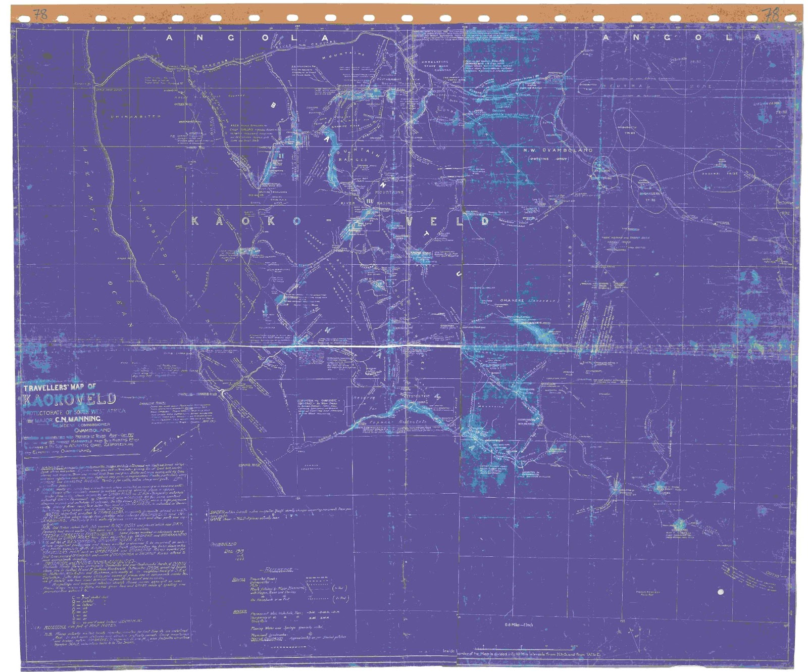
‘Traveller’s Map of Kaokoveld’, compiled in ca. 1921 by Major C.N. Manning, Resident Commissioner of Owamboland, from journeys in 1917 and 1919. National Archives of Namibia.
Manning’s journeys in 1917 (and 1919), are reconstructed here and mapped online here, focusing on his experiences and his impressions of the territory and peoples of north-west Namibia in this important historical moment. This documentation clarifies a number of dimensions and dynamics for the north-west in its relationship with the changing colonial state:
- Damara at Khowarib, in patron-client herding relationships with Nama in Sesfontein [cf. Manasse |Nuab**]
- German sergeant remains in Sesfontein
- Oorlog / Muhona Katiti power struggles
‘During this year MUHONA went across the Kunene and killed a herd boy of Jacob Erickson’s (living in Angola) and he stole 150 cattle bringing them back to Muhonga. I have one of Erickson’s riding oxen and know his brand. Many people have seen the same brand on cattle Muhona has. The mark is – on right –‘ (statement Vita to Manning, Sesfontein 9 Aug 1917).
- Angola / Kaoko overlapping interests
- different linguistic groupings and relationships with colonial administration
- indig relationships with commercial hunters e.g. Vita Tom hunted with his father Bechuana Tom with elephant hunters Green and Erickson.
Overall, this moment is described as when ‘the South African government took hold of the region [north-west Namibia], disarmed local people, and established three tribal reserves’[103].
On 5th October, after much ‘official correspondence between the Union Government, the Governor General of the Union, the French Government and the British War Cabinet’, 23 of the Cameroonian PoWs were repatriated from Aus (see 1915) to the Cameroon, with ‘ten women and a child which had been allowed to accompany them to German South West Africa’ while one of the Cameroonian PoWs, Ambasamissi, chose to remain and went to work in Lüderitz[104].
Tswana from Lake Ngami region are given permission ‘to graze their animals and use water in the Ju|’hoan area located in the Nyae Nyae area’ of South West Africa, travelling through |Kae|kae and Dobe areas of western Botswana to get there[105].
1918
Following German capitulation and the signing of the armistice agreement on 11 November at Compiègne in France[106], the British pound again gains in value (see 1916)[107].
Amidst confidential communications in January by the British Government to the governments of Australia, New Zealand and South Africa on the need to gather evidence of German treatment of natives in their colonies so as to support the post-war retention of German Colonies[108], the ‘Blue Book’[109] or Report on the Natives of South West Africa and Their Treatment by Germany is published by the British South West Africa administration. The Blue Book draws on 47 African testimonials in documenting German colonial treatment of Africans in the territory and supporting the South African claim to the award of a League of Nations mandate[110]. Its principal author, British military magistrate Thomas Leslie O’Reilly, resigns in November after no action is taken regarding his reports of ongoing corporal punishment of natives[111].
The Blue Book is controversial. Kanzler claims that it is being drawn up whilst war is still raging as a strategy to support the ‘relieving’ of Imperial Germany of its colonies by Britain, thus:
[w]hile the war is still raging, Britain already draws up one of the so-called ‘Blue Books’, in which German offences are listed - as ammunition for the peace negotiations which are expected to follow. ‘Proof’ of the brutality and incompetence of German colonial administrations is collected in the German colonies to serve as legal and moral arguments for seizing them and deporting their German population. Already from 1917 onwards South African officials are putting together a ‘list of sins’ - a ‘Report on the Natives of South West Africa and their treatment by Germany’ - which is later integrated into the Blue Book.[112]
O’Reilly observes in the Blue Book that ‘[t]he chief cause of all the trouble between Germans and Bushmen was that the Germans would persist in taking the Bushwomen from their husbands and using them as concubines’[113].
Major J. Herbst [see 1908], secretary for South West Africa at the time, states of Bushmen and game laws that:
the strict enforcement of the game laws has made the country unsafe for them. They profess to be unable to understand by what right Government protects the game and invariably ask to be shown the government brand on the animals.[114]
The Blue Book frames Bushmen ‘as people whose knowledge of wild plants and animals was unsurpassable’[115].
Under the heading “The Berg-Damaras of South-West Africa” the “Blue Book” reports:
In addition to the Hottentots and the Hereros, there live in scattered bands or groups throughout the countries known as Damaraland and Great Namaqualand survivors of the once numerous race of Berg-Damaras (called by the Hottentots “Klip-Kaffirs” and “Dirty Damaras”).
According to various estimates the population of this tribe at the time of the German annexation in 1890 was probably not less than 30,000 to 40,000, and it may have been much higher. Estimates were based on the numbers in a state of slavery under the Hottentos or in a state of semi-independence under the, at times, rather doubtful “protection” of the Hereros.
No estimate could possibly be formed of the considerable number who, under force of circumstances and to avoid slavery and worse, had adopted the habits of the wild Bushmen and, under petty patriarchal chiefs, shared with them the shelter of the remote mountain caves and the most impenetrable bush.
[…]
The origin of this ebony-skinned race, which now speaks pure Nama (Hottentot) still remains, like their now dead language of which no trace is retained, a fascinating puzzle for the ethnologist. The report mentions theories of origin and migration, e.g. to Hugo Hahn [see 1876] and other writers and continues to refer to Schinz.
Dr. Hans Schinz, following the views of the great majority of missionary students, holds that while the Bushman was the aborigine of South Africa and South-East Africa, the Berg-Damara was the South-West African aborigine, and that the great Bantu influx which drove them a wedge across Central Africa right to the western coast line had the effect of isolating the Berg-Damaras in the south.
This view is probably the correct one. They are not Bantu people. Circumcision and other characteristic Bantu customs are not known to them. The writer has had long discussions with the present hereditary Chief and his older councilors, but beyond the fact that they are able to give the names of no less than fifteen Chiefs who at various times ruled over the, and unhesitatingly assert that they were the first people in this land, one can glean very little of their mysterious past.
In reply to questions, the Chief Judas Goresib [see 1894] of Okambahe (the head village), in the Omaruru district, who is a fine dignified specimen of black humanity, said:
“We are the original inhabitants of the country now known as Hereroland. My people were here long before the Hereros and Hottentots came. Our Chief’s village used, many years ago, to be at the place now known as Okanjande near the Waterberg. It was known to us by the name of Kanubis. Later on the Ovambos (the Chief is certain these were Ovambos. He says that the Herero were in the Kaokoveld at that time) drove our people away and they trekked south, and had their chief town where Windhuk now stands, we called it Kaisabis (= the big place) One of my ancestors, Nawabib, was Chief then. It was only later, by agreement with the Herero Chiefs (Willem Zerua and Kamaherero) that we shifted our chief town to Okambahe during the Chieftainship of my great uncle Abraham.[116]
O’Reilly describes Berg-Damara under Herero rule and under German rule [see also references 1895 republic South Africa, 1918] to finish his section on “Berg-Damaras” with the”Chau-Damara”:
The wild Chau-Damaras’ views are also of interest. The writer succeeded in finding a comparatively tame and intelligent member of this class, Jacob Dikasip, living at Ghaub, between Grootfontein and Tsumeb [see 1895 & above] under the so-called Bushman Chief, Johannes Kruger. Johannes is a Bastard who in the early days had hunted with Erickson, Green and others. Eventually he settled down near Grootfontein, and in 1896 was formally appointed by Governor Leutwein as Chief of the Bushmen, Berg-Damaras, and other natives in the Grootfontein areas [1895 0r 1896?, different dates in same source, see above]. Jacob Dikasib said:
“I have been under German masters and have been brutally treated. I show you the scars on my back from the floggings I have received… (he was marked like a zebra)… I look old and worn, but it is from the bad treatment…. See! All my teeth in front are knocked out. A German policeman Grossman did that. I had been pulled down for a flogging, and it hurt so much that I tried to get away, whereupon I was hit on the mouth and lost my teeth. I don’t wish to see Germans ruling this land again, they have been too unjust. They came into the country, and ever since they came natives have been killed and flogged and beaten nearly to death. We never got justice or fair treatment… We cannot agree with the Germans, we hate them. A German has no respect for our women. They have been known to come into the pontoks and chase married men out of their beds in order that they might sleep there. We protested, but what could we do?… I have seen this sort of thing with my own eyes.
Innumerable statements of this nature can be produced, but once again the details are too indecent and revolting for publication. The Berg-Damaras never at any time rebelled or gave any trouble to their German masters, yet it availed them nothing. The treatment meted out to them seems to have been exactly the same as that received by the other tribes.[117]
A transcript from Johannes Kruger, ‘an intelligent Cape Bastard’, appointed in 1895 by Governor Leutwein as ‘“Chief” of the natives of Grootfontein’ [see 1895], is also published this year in the Blue Book:
The first German I met was Von Francois, who passed through Grootfontein with troops towards N’gami. Some years later Major Leutwein came to Ghaub with Dr. Hartmann, the manager of the S.W.A. Company. He stayed there only a day and drew up an agreement for me to sign, wherein I was appointed Captain of the natives and had to recognize German sovereignty and control. Leutwein said I was Captain of the Bushmen and Damaras and of all people who lived at Ghaub. The agreement was signed on 31.8.1895. I identify the original agreement and my signature now shown to me. (Original agreement read over the deponent.) I signed the agreement unwillingly. I at first refused to sign it, but they (Leutwein and Hartmann) insisted, so I eventually agreed.
I knew the Bushmen had no real Chiefs, and that every head of a family was practically his own Chief and master. I told Leutwein that Bushmen would not readily submit to a Chief, especially as I was not a Bushman. The reply was that as I know the language and the people I might have influence over them. The Berg-Damaras, I felt, I could control, and also the Hottentots, though the Hottentots in particular strongly objected to the agreement being made. They said they did not want to be German subjects and preferred the English. The Berg-Damaras said nothing, and the few Bushmen were also silent, as they understood nothing of the matter. After the agreement was signed, Harmann gave me 5l. a month. I had to provide labourers for the Company. I then tried to collect people to live in Ghaub which, under the agreement, was given to us. I collected in time 212 Heikom Bushmen (men, women, and children) also 110 Berg-Damaras, and these, with the 35 Hottentots all lived on my werft at Ghaub. They all agreed very well, but the Bushmen only remained a short time, as there was not enough “veld kost” (wild fruits, roots, herbs &c.) for them to live on. They had no stock. So they scattered and returned to the bush. Later on the Bushmen began to offer their services as labourers on the farms of the German settlers. The majority of the Heikom (several hundred families) left the bush and came in to the farms. Then the trouble started. The German farmers refused to pay them their wages, they said food and tobacco were enough for them. They did not want money. The food was poor and the Bushmen complained to me. I spoke to Lieut. Volkmann, the German Magistrate, and said the Bushmen were a wild people, but if they were properly treated and fed and got a little money, just a little, they would get tame and become useful. He made promises, but nothing came of them. We got no redress. As a rule a Bushman only has one wife. If she is barren he may take another, but never has more than two. The majority of the Bushmen have only one wife. They are extremely fond of their women, whom they treat well. The Germans started to take their wives away from the Bushmen and made concubines of them. The whole district is full of these German-Bushwomen cross-breeds. This conduct of the Germans annoyed and irritated the Bushmen more than anything else. They deeply resented it; I received numerous complaints from them. I made representations to the German Magistrate, Volkmann, but the trouble continued. This resulted in the Bushmen refusing to work on the farms unless compelled by hunger to do so. Then they began, for the first time, to steal cattle of the Germans and rush them away to the bush. One Bushman whose wife had been taken in this way, murdered the German farmer who had despoiled him. Bushmen were shot on sight by the police and German farmers, and no mercy was shown to them. Those who were shot were men who, too afraid to stand, ran away on being seen by a German patrol or a farmer. They were in state of terror. Often the Germans surprised and captured families of Bushmen in the veld. These people were then transported, with women and children, to Swakopmund or Luderitzbucht to work. Many died down there [see e.g. 1911-1914]. I only say two who had escaped and returned to the bush there. They said all their people perished there of cold and exposure. The Bushmen are human beings after all, and resent their wives being taken away, and object to ill-treatment. They are too terrified now and don’t trust the white men; but in time I think the Heikom will settle down and become useful labourers if well treated. The Kung or Kalihari [sic] Bushmen are more fierce than the Heikom, and will not readily settle down. I have always got on well with them though, and never was molested by any of them. The white men, especially the Germans, treated them as if they were wild animals, and therefore they retaliated and are naturally wild and timid. The Germans treated all natives with harsh brutality and gave them no justice. They all hate the Germans. The majority of natives here have from time to time been badly flogged and thrashed for all sorts of small offences, such as petty thefts or vagrancy or laziness or impertinence. They were spoiled and driven to desperation by suppression, any many offences they committed and impertinence and lack of respect arouse out of the Germans’ intimate and immoral relations with their wives and daughters. If a native objected and was cheeky he got flogged for insubordination and impertinence. This was in peace time. In war time a German showed no mercy to man, woman, or child.
We are very unhappy under German rule and I often deeply regretted their having come here. But what could we do – we were too weak.
I know the natives of Grootfontein. They are all much happier now than they were under German rule. They talk all day long about the new Government, and say they hope and pray that England will keep this country and govern us. They are in terror at the very idea of a German Government coming back. They say they will all be killed, and will flee away to another country rather than stay. I say the same. The Germans hate me because I tried to protect my Bushmen and Damaras. I reported their cruelty, and they blamed me when the natives deserted their service. I won’t stay here if the land is given back to Germany. I don’t believe any of us will remain.[118]
Two Damara Truppenspieler ‘companies’ are reported to be drilling in the Old Location in Windhoek[119].
Levi |Nabeb |Uixamab, kaptein of Sesfontein, dies and his son – Nathanael Husa |Uixamab – by Levi’s wife Katrina Maria ǁÂwes [family name?] succeeds as chief[120].
Isaac Witbooi and some of his leading councilors are arrested following concerns regarding his consolidated authority (see 1916 above), signaled through wearing white cloths on their hats in commemoration of Hendrik Witbooi who resisted German rule[121].
Namibia is affected by influenza epidemic[122], which sweeps through the PoW camp at Aus in October and November, where 59 PoWs and 50 members of the garrison and assistance units die[123].
At the end of the year,
the government of South Africa orders the expulsion of Germans living in South West Africa. They are classified into five groups: (A) active members of the colonial forces, (B) public servants, (C) policemen, (D) persons willing to leave and (E) undesired subjects. While the first four groups are clearly defined, the fifth one leaves room for interpretation. In a letter, dated 1 April 1919, the Administrator in Windhoek instructs the military magistrates countrywide to “without delay, ( ... ) compile a list of persons ( ... ) who, in your opinion, it would be desirable to remove from South-West Africa”. As examples he includes people who mistreated natives in their employ or who violated the licensing act, people of dubious reputation and people who have expressed hostile feelings towards Britain. The magistrates are also asked to add whether the persons in question are making a valuable contribution to the country.[124]
Popular writer Lawrence Green writes that when he landed at Walvis Bay ‘shortly after World War 1’ water distilled using a condenser was sold a five guineas a thousand gallons, falling only after a pipeline was laid to Rooibank on the Kuiseb River[125].
Reinhardt Maack, who is preparing a map of the Brandberg, ‘discovers’ the ‘white lady’ painting in the Tsiseb ravine on the east side of the Brandberg, and immediately attributes ‘a Mediterranean origin for the paintings as they reminded him strongly of Egyptian frescoes’[126].
Winifred Hoernlé publishes her first article from her Nama research[127], in which she applies the theoretical model regarding ritual of Swiss sociologist Arnold van Gennep to,
Four surviving rituals of transition among the Nama … those relating to puberty, marriage, illness and death. In each case, she traced the ritual process by which the individual-in-transition, or ‘crisis’ in Van Gennep's terms, was isolated from society, then treated and tutored by elders to protect them from the dangerous potency associated with their liminal status, before being ritually prepared for their reintegration into society with a new social status. Her application of Van Gennep's model to southern African ethnographic data was pioneering, even if her data was less complete than she would have liked. Her applied sociological analysis of African rituals as involving the resolution of life crises and liminal identity through stages of ordered and protective social management remained the dominant approach towards the analysis of ritual in the southern African ethnographic literature of the interwar years. This was because the most significant studies of ritual would be penned by her Wits students, for whom her 1918 essay and a further trilogy on African ritual published in 1923 and 1925 would be core undergraduate texts.[128]
1919
The Treaty of Versailles is signed on 28 June[129] following agreement of terms in April[130] assigns German SWA to be administered by South Africa as the Mandate of South-West Africa[131]. A retaliatory ‘White Book’ [see 1918] on The Treatment of Native and Other Populations in the Colonial Possessions of German and England is published by the German Colonial Office in Berlin[132].
PoWs leave Aus[133] and thousands of German settlers in South West Africa are expelled (as are Germans from German East Africa, the Cameroon and Togo), amidst claims of unscrupulous speculation on ‘their’ properties[134]. From April 1919 to February 2000 nearly 6,000 German men, women and children are deported using 11 steamers sailing under the British flag of which three are captured German Woerman line ships[135]. On 19 September the South African settlement law, ‘under which government loans are granted to landless sons of farmers for establishing their own farm’, is amended to include GSWA[136].
Under South African martial law, Proclamation 15 of 1916 decrees that no person can ‘cross the line marking the Police Zone without permission and this became known as the Red Line’[137]. The Prohibited Areas Proclamation (Proc. 15 of 22 March 1919) by the ‘South African military administration’ confirms the existence of the three Game Reserves proclaimed in 1907 with permanently manned police posts established at Namutoni and Okaukeujo, and also controls entry into Owamboland and Rehoboth[138].
A second trek and associated reporting is made to the Kaokoveld by the Resident Commissioner of Ovamboland, Major Manning. In his report ‘Kaokoveld’, he iterates prejudicial perceptions of these two leaders, characterising Vita Tom as ‘lawabiding’, ‘highly intelligent’, having ‘good presence and personality’, and being ‘a well-known and conspicuous figure … far more accessible than the wandering savages’, whilst Muhona Katiti is described as ‘a savage of the Ovatschimba class’ and the leader of ‘wild nomadic people who [are known to be well armed’[139].
Jacobus Christian, son of the Bondelswartz leader Willem Christian, returns to SWA from the Cape.[140]
South African historian George McCall Theal observes of ‘Bushmen’ that:
It can now be asserted in positive language that the Bushmen were incapable of adopting European civilization .... To this day there has not been a single instance of a Bushman of pure blood having permanently adopted the habits of the white man.[141]
Post WW1
Boreholes are provided by the South African administration ‘as part of a policy to discourage nomadism’, including at the entrance to the Hungorob ravine, south side of the Brandberg, and ‘[l]ocal men were … issued with rifles to protect their herds from the packs of Cape Hunting Dogs Lycaon pictus’, both innovations perhaps associated at the Hungorob with ‘an increase in the size of the herds and a need for the construction of large enclosures’, as evidenced by ‘several brushwood stock enclosures’ at the Hungorob[142].
Following WW1 and as the territory came under Union of South Africa ‘protection’, the area stretching from the Kunene to the Hoanib River in the south becomes increasingly known as the ‘Kaokogebiet’ (i.e. ‘Kaoko area’) and ‘Kaokoveld’[143].
1919-1921
Severe drought in the south of the country – only 50mm/year at farm Karios (currently Gondwana Cañon Lodge)[144].
1920
Radcliffe-Brown is invited to establish social anthropology at UCT[145].
Following diplomatic pressure from US President Woodrow Wilson and following the deportation of Germans from German East Africa, Cameroon and Togo[146], the last ship with German deportees from SWA leaves in February[147]. Consolidated Diamond Mines (CDM) takes over German diamond companies[148] and the new SA government requires the RMS ‘to pay off its debts’ [see 1924][149]: i.e. The KLMG is disowned by the new South African government of SWA[150].
The Masters and Servants Proclamation and the Vagrancy Proclamation are enacted making ‘it a criminal offence for native workers to leave their employment without their bosses’ explicit consent’[151].
White South Africans including the de Vries / Levin family [who later acquire ‘Twyfelfontein’, see 1947] encouraged by the Union of South Africa begin moving into the southern areas of SWA in the wake of post-WW1 dispossession of German settlers, followed in some cases by movements back and forth across the Orange River as necessitated by economic circumstances and opportunitiesaa[152].
Part of the Himba group that had moved north over the Kunene in response to raiding in late 1800s by Nama settled in Sesfontein ‘again moved southwards into central and southern Kaokoland, although others remained in southern Angola’[153]. Here, being in an impoverished state relying on gathering and hunting, they were known as those who beg or request (ovaHimba / sing. omuHimba), although the lost herds were soon regained by raiding and and successful alliances[154]. Owen-Smith writes that ‘[a]fter the turn of the century, these Himba [who in the late 1800s had fled across the Kunene River from Nama raiding in the Kaokoveld], under Oorlog Tom, accumulated large herds of cattle by subduing the neighbouring tribes. Many returned to the Kaokoveld with Oorlog in 1920, where they settled in the northern highlands and absorbed the local OvaTjimba’ – retaining a ‘mode of dress and nomadic way of life … governed by ancient traditions’[155]. Vita Tom / Oorlog presents Lieutenant Olivier seven head of cattle during the Lietenant’s first visit to Kaokoland, an act interpreted as his seeking of support from the white authorities[156]. Major Manning as Resident Commissioner for Owamboland goes on tour to the Kunene river for the Boundary Commission, accompanied by C.H.L. Hahn and René Dickman[157].
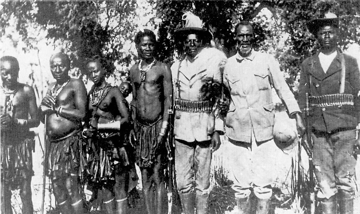
Vita Tom (Oorlog) carrying pith helmet and wearing South African army uniform. Source: Bollig and Heinemann 2002, p. 282, photograph taken by ‘Cocky’ Hahn, (n.d.) NAN.
Moritz writes,
[i]n 1920 Gaub had a size of 9173 ha. This meant pasture for 1000 head of cattle. … Also fruit trees and wine were grown. In 1920 three German families lived on Gaub. As natives there were only Bergdamara. Twelve able-bodied men were employed as farm workers. Nine older men who used to work here 21 women and 45 children lived here. In the places belonging to it lived 9 Damara men and nine women, 19 children, and three children, as well as three Bushmen with one wife and five children and one Ovambo as a shepherd[158].
The Universal Negro Improvement Association (UNIA) is founded[159] by Marcus Garvey with ‘its own ranks, uniform and titles’ becoming an inspiration for Namibian Herero Truppenspieler (soldier players) known amongst Herero as Otruppe[160].
Two NCOs (Native Commissioner Officers?) ‘apply for a license to build a “native cinema” in the Windhoek location’ writing,
It is recognized by us that the native in this country is inferior in intelligence and by installing an entertainment such as herein suggested it would in our opinion have a tendency to raise them to a higher standard educationally … [through showing only pictures of] high educational value which had been previously scrutinized,
but their application was ‘turned down’ by the Administrator saying that he felt ‘the time was not yet ripe for such an experiment’[161].
By this year CBPP is mostly contained in commercial farming areas[162].
Early 1920s
A League of Nations ‘C’ Class Mandate is awarded to South Africa[163] in which the Union of South Africa is to hold South West Africa in trust with no changes in citizenship and rights conferred to the local population that they can ‘lodge complaints with international control bodies’[164]. Day-to-day administration was ‘under white South Africans, working within the framework of South African law, including the extending network of laws to entrench racial segregation’[165]. Central government attempts at containment and rationalisation are continually subverted by local realities and agendas[166]. A political agenda of building ‘a unified white settler community’ becomes important[167]. International borders are instituted and trade across them is suppressed leading to local herders in the north-west to be ‘forced back into subsistence pastoralism’[168]. The Land Settlement Programme settles large numbers of white farmers from SA in SWA, around 10 per cent of whom are ‘fairly well financed’, providing grants of 400 pounds for the building of a permanent dwelling (cf. remaining farmhouses on now communal land)[169].
The official Police Zone border is ‘drawn onto Namibian maps with a clearly marked red line’[170], and ‘reinforced by a chain of police outposts placed at intervals along its length’[171]. It ‘physically mark[ed] the transition between “white” European southern Africa and the “black” interior, between that which was “healthy” and that deemed “diseased” … the line drawn between what the colonial power defined as “civilization” and what it considered “the wilderness”’[172]; or the line between ‘tribalised’ and ‘detribalised’ Namibians[173]. People are ‘expelled from their lands between Outjo and Kamanjab by the colonial government … [so as] to make way for white settlement’, [25] with most farms ‘undercapitalized and highly government-subsidized’[174]. The Land Settlement Programme settles large numbers of white farmers from SA in SWA, around 10 per cent of whom are ‘fairly well financed’, providing grants of 400 pounds for the building of a permanent dwelling (cf. remaining farmhouses on now communal land)[175].
A new body of legislation from South Africa thus comes in to regulate labour flows and control indigenous populations[176]. Occupants of crown land (who often had relocated to land dispossessed during German rule) were forcibly removed to newly established Native Reserves in Police Zone where livestock possession and identity reconstruction could take place, albeit under conditions of inadequate resources[177]. For ‘Kaokoveld’, regulations are administered from Ondangwa and ‘enforced by numerous police patrols into the area’[178].
Despite centuries long influence by the Portuguese in Angola, the territory is only formally colonized in the early 1920s[179].
Guano from the islands off the coast is harvested for South Africa during the 1920s and beyond:
[o]nly a limited amount is removed annually, and the ‘guano season’ takes place between April and September when the birds are away from the islands. On some of the islands are small permanent settlements which depend upon vessels from Cape Town for water and provisions. The men go sealing during the off season, and when the time comes to remove the guano they are assisted by groups of laborers sent from Cape Town. On Ichabo is such a settlement - a few white men with women and children, besides a number of natives. The Government Guano Islands, as they are now called, are the leading source of nitrogenous fertilizer within the Union.[180]
1921
In January, Alfred Reginald Radcliffe-Brown, a ‘founding father’ of ‘the British anthropological tradition’ of ‘structural-functionalism’ (influenced by Durkheim’s ‘structuralism’ and emphasis on general laws of society), and teacher of Winifred Tucker Hoernlé who conducts field research amongst Nama of ‘South West Africa’, establishes social anthropology ‘as a modern, professional university-based discipline’ as professor and head of ‘the social anthropology department in the newly created African School of Life and Languages’ at UCT.[181]
SWA is mandated by the League of Nations to be administered by South Africa in its own right, after administering the country in the name of Great Britain[182]. The Mandate speaks of the indigenous population being placed in the “tutelage” of an “advanced nation”, as “a sacred trust of civilization”[183]. The territory becomes ‘the object of an ambitious Land Settlement Programme for poor white (although not destitute) Afrikaners from the rural north-western Cape’[184]. The Native Reserves Commission generates legislation to set up demarcated Native Reserves in each of the principal farming districts of the Police Zone and establishes conditions for native settlement and movement[185]. The ‘Zessfontein Reserve in the Kaokoveld was to remain undisturbed’[186]: 31,416 ha reserved for ‘Topnaar and Swartbooi Hottentotten’[187].
**1939 map of Native Reserves established in Police Zone in 1921. Source: Hayes et al. 1998: xv.
New and excalating location regulatons in Windhoek attempt to impose hut taxes and passes for most adults (excluding married women) and are resisted[188]. The Industrial and Commercial Workers’ Union (ICU) is established[189].
Major C.H.L. ‘Cocky’ Hahn becomes Native Commissioner for Owamboland and Kaokoland[190]. Manning writes a letter to the Royal Geographical Society in 1921 describing his travels and affirming in particular the assistance of local people. He writes that he was:
particularly assisted by the comparatively few wild native inhabitants (viz Herero Bantu type and Hottentot-Bushman Nama type) of the remoter parts who not only guided me and explained matters along many hitherto unknown mountain routes, - frequently without even footpaths or the often useful elephant and other smooth game tracks through stones and bush, - but pointed out water in secluded kloofs and in beds of rivers which once flowed; abandoned settlements of previous generations, sacred piles of stones called OMBINDI to which travellers added something conveniently picked up muttering a few words to propitiate the spirits; method of making fire with sticks and perpetuation of family fires wich [sic] were also regarded with reverence and as altars in case of sickness etc; they also pointed out occasional rhinoceroses, elephants, giraffes and so forth which were very abundant before that greatest of all exterminators of the finest varieties of game viz the European’s firearm.[191]
Game Preservation Proclamation (13 of 1921), based on German laws, makes the South African police responsible for regulating hunting and game protection[192].
Manning is transferred to Windhoek[193] (and contracts debilitating malaria), and René Dickman is also transferred from Owamboland to represent colonial authority in Kuring Kuru in Okavango[194].
The German eugenicist Dr Eugen Fischer publishes The Principles of Human Heredity and Race Hygiene from research on corpses from the concentration camp on Shark Island[195].
The Dias padrão at Lüderitz is undamaged and in situ until this year[196].
Daniel De Pass of Daniel De Pass & Co. dies, ‘leaving a considerable estate’[197].
1921-1930
1,519 SA white families are granted land holdings in SWA, especially from north-west Cape[198].
1921-1941
Nathanael Husa |Uixomab takes over as Headman of Sesfontein from his father Levi |Uixomab[199].
1921-1947
Following the 1921 mandate, SA uses the space of the mandated territory for the immigration and settlement of poorer whites in SA[200]. The territory is constructed, visually and otherwise, as uninhabited terrain, supported by a discourse of ‘vacant land’ legitimately available for appropriation by the new administration[201].
SA administration in Kaokoland, especially under Major C.H.L. ‘Cocky’ Hahn (also known to the Ovambo as Shongola, i.e. ‘whip’[202], and grandson of founding Rhenish missionary Carl Hugo Hahn[203]) as Native Commissioner for Owamboland and Kaokoland from 1924-47, which included wardenship of the then Namutoni Reserve which later became Etosha Game Reserve[?Game Reserve no. 2 already existed?][204], embarks on three interrelated processes:
- establishing boundaries that divided Kaokoland from surrounding areas;
- creating chiefs as intermediaries through whom the area and peoples could be confined and controlled – including the replacement of the Kwanyama kingship with a Council of Headmen in Oukwanyama, including prior enemies of king Mandume[205];
- promoting specific ideas regarding livestock and resource management, involving vaccination campaigns and the criminalisation of hunting.[206]
Regarding ‘conservation’, in an undated archived document called ‘Big Game in Ovamboland’[207], Hahn makes some important comments and observations including the following:
Detached portions of the scattered herds that survive in the Kaokoveld visit Western Ovamboland at intervals during the wet months, where, owing to the easier hunting conditions and the fact that they approach closer to - and even occasionally enter - tribal areas, they are more liable to persecution, as even amongst the Ovambo ivory is in great demand.
He observes that ‘game’ including elephants move seasonally into western Ovambo from Kaokoland, and mobilises Owambo headmen to control local hunting, thus:
I am glad to place on record the assistance and co-operation tendered me by Chief Martin [ka Dikwa of Ondonga], the ruling chief of the largest tribe in Ovamboland. It has been through his help that the bulk of areas I visited are closed to the depredations of his subjects, where in former years they slaughtered and hunted at will.
And notes that ‘the Kwanyama “readily fell in line”, and that Chief Muala (of Uukwaluudhi) also helped prevent the “indiscriminate butchering of game”.[208]
In an undated letter to L. Fourie, Hahn speaks very critically of government officials turning up at Etosha Game Reserve on excessive shooting trips[209]. Nonetheless, he also reportedly ‘cherished the idea of making the northernmost parts of the Kaokoveld a game reserve which would offer “fine opportunities for tourists and sportsmen to shoot trophies under special licences and instructions”[210].
Hahn also represents the Union of SA at the Permanent Mandates Commission of the League of Nations[211].
1920s-1930s
In these decades,
[t]he status of the southern parts of Kaokoland remained vague … as to whether new farms for white settlement would be declared there or more Herero from the police zone would be settled there, [but] it was clear that major parts of Kaokoland would serve as a tribal reserve and a buffer zone to the little administered southernmost parts of Portuguese Angola.[212]
District Commissioner Hahn makes many photographs of hunts, for example in Kaokoveld, depicting ‘the sportsman’s ideal of trophy-hunting’ and making visible ‘the comprehensive dispossession of Africans with regard to their hunting rights’[213]. Kaokoveld is the focus of scientific curiousity and attention regarding ‘the quest for the quagga, a specific subspecies of zebra’, thought to perhaps remain in this ‘frontier’ area[214].
1922
In Germany, Hitler is ‘recruited into an ultra-right-wing militia in Munich’, indirectly under the command of General Franz von Epp who ‘had been a lieutenant during Germany’s wars against the Herero and Nama’ and a firm believer in Lebensraum theory which, like north American theories of ‘manifest destiny’, justified for Germany a need for an expansion of space for settlement[215]. Through this connection, von Epp’s deputy Ernst Röhm - ‘founder of the Nazi storm troopers’, with Hitler, ‘were able to procure a consignment of surplus colonial Schutztruppe uniforms. Designed for warfare on the golden savannah of [South West] Africa, the shirts were desert brown in colour: the Nazi street thugs who wore them became known as Brown Shirts’[216].
A 1922 proclamation (no. 11) by the Native Administration allows ‘the reservation of what amounted to less than 5% of land in southern and central Namibia as Reserves for Africans who comprised over 90% of the region's population’[217]. In north-west Namibia these first Reserves were Fransfontein, Okombahe, and Sesfontein inhabited by primarily Khoekhoegowab-speaking Damara-Nama[218]:
these [and other] Reserves were periodically expanded through
the purchase by government, and incorporation, of a neighbouring farm. Such expansion occurred either in response to requests generated by the inhabitants of the Reserves themselves and mediated by the Reserve Boards in charge of their day-to-day administration, or due to an agenda set by the Administration. [14][t]he establishment and maintenance of these [and later] Reserves alongside the growing area of titled commercial farms heralded the beginning of the current dichotomy between communal and commercial land in southern Namibia and their associated production systems[219].
Kaokoveld is proclaimed as a reserve for primarily Otjiherero-speakers [220] under Outjo District for Chiefs Oorlog Thom, Muhona Katiti and Kasupi, the three Herero leaders inhabiting the region at the time[221]. Oorlog Thom, with well-armed Herero and Himba followers, is entrenched as most powerful ruler north of Sesfontein[222].
The RMS missionary Vedder, fluent in Otjiherero, Khoekhoegowab and Oshindonga, returns to SWA (having been sent out of the country after WW1[223]), settling in Okahandja ‘as missionary and teacher trainer’[224].
Guano continues to be harvested from the Government Guano Islands for use as fertilizer in the Union of South Africa with 9,394 tons shipped from Ichabo in this year, where a small permanent settlement of ‘a few white men with women and children, besides a number of natives’ are living, as on other guano islands (e.g. Halifax)[225].
Bondelswartz Uprising #2
The Bondelswarts Rebellion starts on 29 May[226] with Abraham Morris as a leader who is killed in this campaign[227], responding to increases in taxation[228] (e.g. on dogs[229], i.e. which restricts hunting practices’[230]), and is bombed by Union Defence Force aircraft with oral testimony asserting that the Bondelswartz shot down one plane[231]. Jacobus Christian, son of the Bondelswartz leader Willem Christian, is convicted as one of the leaders[232].
The South West African National Congress (SWANC) is established[233].
Administration of Walvis Bay is handed to the mandated territory of South West Africa (not to South Africa)[234].
The South African Drought Commission influences policy towards environmental protection[235].
Legislation is introduced to control the utilisation of seals, following the eradication of colonies from 23 islands along the South African and Namibian coast[236].
1922-1923
From December to April, funded by the South African government in SWA[237], anthropologist Winifred Hoernlé makes her third and final expedition to South West Africa[238]. Her research is conducted in the wake of recommendations by the South West African Native Reserves Commission for a policy of ‘native reserves’, aka South Africa’s Land Act of 1913, and her brief ‘was explicitly political’ – ‘to conduct studies among the remote Nama “tribes” that could be used as evidence to motivate for the development of Nama reserves’[239]. Hoernlé instead spends most of her time in the Windhoek location, also again visiting Sandfontein in Jan-Feb 1923, seeking ‘to expose the appalling conditions of the diverse Nama communities’ living there, documenting their ‘grievances about new charges introduced by missions, schools and marriage officials’ including testimonies such as, “under the Germans our backs knew no rest, but this government does not know how to keep its hands out of our pockets” and “yes, the money is put into our hands, but it slips through our fingers, and the hand of the government is waiting underneath to catch it as it falls”[240]. Her report draws ‘attention to the terrible poverty that prevailed and the power that the colonial administrations – German and South African – wielded over the indigenous people’[241]. These findings ‘did not sit well with the South African officials, one of whom, rather ironically, scribbled across her final report: “Politics not Science”’[242]. In Sandfontein, and connected with her desire for a more intimate as opposed to objective relationship with her ‘informants’, she is able to document ritual in more depth than previously[243]. In the Windhoek location she witnesses four Nama rituals: ‘a funeral service, a reed dance, a rain-making ceremony [in January 1923[244]] and a girls’ initiation ceremony’[245].
Captain G.C. Shortridge reportedly estimates 150 rhinos from Ugab to Kunene rivers,
in ‘what is now western Kunene Region’[246].
1923
Whilst in Landsberg Prison in Germany, Hitler reads Fischer’s The Principles of Human Heredity and Race Hygiene published in 1921 from research on corpses from the concentration camp on Shark Island, later appointing Fischer to the post of rector of Berlin University[247].
The South West African Native Reserves Commission policy of ‘native reserves’, aka South Africa’s Land Act of 1913, is passed[248]. Government Notice No. 122 confirms grant of the farm Zesfontein made by the German Government for the use of ‘Topnaar Swartbooi Hottentots’ in 1906[249]. Tses and Berseba in the south are also declared as ‘native reserves’[250].
In Lebzelter’s work the Bergdama of Hereroland divided into the various residential areas according to the 1923 census in which A total of 23,622[? Total of figures below is 23,365] Bergdama were counted: Gibeon 809, Gobabis 800, Grootfontein 2199, Karibib 4081, Keetmanshoop 580, Lüderitzbucht 205, Maltahöhe 245, Okahandja 1200, Omaruru 2068, Otjiwarongo 1568, Outjo 1351, Rehoboth 1927, Swakopmund 457, Windhoek 5875[251]. ‘Only 2016 ?[2026] inhabitants of this ethnic group lived in the reserves, which is about one tenth. In Otjimbingwe there were 740, in Okombahe 1094, in Tses 110, on the Waterberg 43, in Franzfontein only 39. In addition there are about 1000 Dama living in the Kaoko field and in the Namib and Kalahari, who were not recorded in the census (Lebzelter [1934] p. 106).’[252]
Three Native Reserves south of the Kunene River are established under Outjo with different ‘chiefs of Kaokoland’s pastoral population’[253] (from west to east):
- Kakurukouye / Kasupi (to whom Viktor Franke had given a gun and established as agent of the German colonial regime in 1900), incorporating the Baynes Mountains and stretching west to Otjinungua on Kunene River;
- Vita Tom, stretching from the Kunene at Epupa (Otjipupa) to Kaoko Otavi and Opuwo, and incorporating the Omuhona River and Otjiyandjasemo (where he had settled in 1917);
- Muhona Katiti, incorporating Swartbooisdrift / Tjimuhaka on the Kunene River, the settlements of Ehomba and Epembe, and stretching eastwards to Ruacana.
Vita Tom was ‘the most westernized and probably the most powerful of the three’ and was ‘deemed to be the leading figure; all three competed ‘intensively with each other for power’; and Vita Tom and Muhona Katiti ‘especially were on bad terms and both aspired for control of the same land – the Omuhonga Basin’ with Kakurukouye reportedly bringing ‘the two together to agree upon a solution whereby Muhonakatiti would settle at Ehomba and Vita Tom at Otjiyandjasemo’[254].
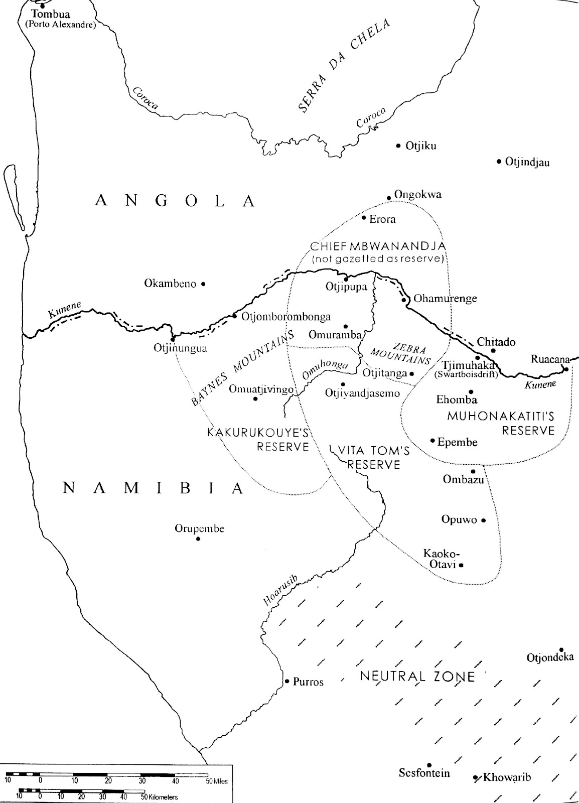
‘Chieftancies of Northern Kaokoland in the 1930s’. Source: scan from Bollig 1997, p. 24.
**what is the ‘neutral zone’, as marked on the map?
Manning makes his last tour of Kaokoland, accompanied by ‘Cocky’ Hahn in March and in April-May[255], reportedly estimating 50 rhinos for this area[256]. Georg Hartmann makes an extensive patrol of Namibia’s northern coast and Kaokoveld, recording ‘several hitherto unknown deposits of guano’ [?check date][257].
South African military officer Shortridge organises the The Third Percy Sladen and Kaffrarian Museum Expedition ‘Ovamboland’ to ‘the eastern margins of the Kaokoveld in the Ruacana region’ with the aim of producing ‘a complete inventory of the fauna of northwestern Namibia’[258]. Despite ‘the general prohibition on shooting game, the expedition was given rather high quotas to hunt for food and to provide specimens for museum exhibitions’ and ‘[f]or the first time animals were photographed from a plane’, including a tantalising photograph of ‘quagga Kaokoensis’[259].
Samuel Maharero dies in exile (on 14 March ?**) and is buried in Okahandja on 23 August after the return of his body from Serowe in Botswana, attended by around 2,500 people[260], including by Damara leaders such as Dax and family (see above)**. His funeral is choreographed by his son, Friedrich Maharero and influenced by exposure to military representation through trip to Berlin in 1896[261]. Herero holy fires (Okuruo), extinguished in 1903, are rekindled throughout Namibia by Herero ritual specialists from the Bechuanaland Protectorate who escorted Maherero’s body to Namibia[262]. In Pos Drie in the Herero reserve of Epukiro Ovambanderu asks Friederich Maharero for information regarding family members who had fled to the Bechuana Protectorate and is informed erroneously that they had all perished meaning that they should transfer allegiance to the Herero of Okahandja – from which they later break away to establish their own Ovatruppe with green flag, Otjingirini[263]. Hosea Kutako creates an African Prayer, later proposed as a National Namibian Prayer[264].
SA government officials calculate that only 184,446 of 602,877 small stock and 30,659 of 84,385 large stock owned by black farmers were located in the Native Reserves, due to ability of black stock-owners to gain grazing rights on white-owned farms in exchange for their labour[265].
De-bureaucratisation after German rule means that the administration consists of only 311 officials of whom 212 were temporary employees, with 284 European and 239 native police and 39 police stations[266].
In Omaheke a Ju|’hoan man, Tsemkxau, mounts ‘a brief armed rebellion’ that kills the region’s white magistrate with a number (perhaps up to 30) of Bushmen killed trying to escape arrest and Tsemkxau imprisoned for several years[267].
Around 10,000 tons of guano are shipped from the guano islands to the Union[268].
Vedder’s Die Bergdama is published in German. It includes, for example, descriptions of Dama clay vessel manufacture, stating that it is men who make pots, a reddish coloured clay is preferred, vessels ‘were made by building up the shape with small pieces of clay at a time and smoothing them down, and that the source of clay is kept secret’[269].
A bulk water supply system is constructed by the South African Union Government at Rooibank[270].
Anthopologist Mrs Hoernlé takes up the post of Research Fellow and Lecturer in Ethnology at the Univ. of Witswatersrand[271]. She publishes her paper on the social value of water among the Nama[272]. She draws on Radcliffe-Brown's definition of ‘social value’:
[b]y the social value of anything, I mean the way in which than thing affects, or is capable of affecting, social life. Value may be either positive or negative, positive value being possessed by anything that contributes to the well-being of society, negative value by anything that can adversely affect that well-being.[273]
She proceeds,
to demonstrate that the concept of water in the cultural system of the Nama was deeply ambivalent, something she explored in relation to belief and ritual. On the one hand, the Nama saw water as having great protective power against antisocial forces. On the other, water was a potential danger to individuals. Here she provided an extended case study, again from her fieldwork in Windhoek location, of the way in which female Nama elders used water to protect a young girl undergoing menstruation. Here too she applied Arnold van Gennep’s model of a ‘rite of passage’ from seclusion to reintegration. She concluded by insisting that African beliefs and rituals were ‘intelligible’ if subjected to scientific scrutiny. She described Nama beliefs and rituals as ‘wholesome’, given that they functioned to the benefit of individuals and communities within an interrelated cultural system.[274]
This assertion of ‘African society as “intelligible”, “rational” and “cohesive” was deeply subversive in the political context of the time[275]. On 14 April she writes a letter to the Secretary for South West Africa, Office of the Administrator[276] stating,
There is no doubt that the people are on bad terms with one another ... They would like a headman with authority to settle disputes, yet the dissensions among themselves as to whom they want have prevented them from putting forward their wishes. The people just brood and bicker in the recesses of their sanddunes, and are infinitely unhappy. They will never move to aid themselves, nor will they leave the bed of the Kuisib of their own accord. NO, as long as the !naras is there, the best food in Africa, as all Hottentots will tell you, the Topnaars will not move. Meantime, members of the various black races of the Protectorate are settling more and more in Walvis Bay, where they are not only ousting the Topnaars from the labour market, but where they are disputing possession of the !nara fields with them also. Altogether, hidden behind the silent line of sanddunes bounding the Bay there is a festering sore of human misery that troubles anyone who approaches it at all closely[277].
1923-1925
After years of ‘fairly dry seasons’, good rains come also bringing locusts that denude the land over the next three years[278].
1923-1937
Winifred Tucker Hoernlé, student of Radcliffe-Brown, is the first lecturer in social anthropology at Witswatersrand Univ.[279] She worked from an ‘anti-segregationist, left-liberal tradition of social anthropology’ encouraging her women students to spend ‘years involved in immersed participant observation through long-term residence among African peoples.[280]
1923-1949
‘Cocky’ Hahn replaces Manning as ‘Native Commissioner of Ovamboland and the Kaokoland’[281].
1924
In the interest of building a unified white settler community assurances are given to Germany by the South African Prime Minister General Smuts that no further reference to the Blue Book of 1918 will be made[282] and Smuts, hoping to annexe SWA with SA, ‘signs an agreement with the government of the Weimar Republic … giving Germans in the mandated territory dual citizenship: South African in addition to German’[283]. General Hertzog, National Party leader, becomes Prime Minister of South African government and refers to the Blue Book as a ‘war pamphlet’[284]. The Blue Book is symbolically destroyed as a form of appeasement between German-speaking and South African residents in the colony[285].
Natives (Urban Areas) Proclamation attempts to enforce and regularise movement of Africans in urban areas[286]. The ‘Report of the Drought Investigation Commission’ advocates ‘exclusive focus on cattle ranching’ (instead of mixed farming of German colonial period), and is concerned with ‘how to extract maximum value from the farming sector without destroying the resource base’ through fenced camps, distribution of water points, rotational grazing and improved market conditions for cattle[287]. Unable to pay its debts, the RMS hands over land linked with the Omaruru mission to the SA government [see 1920][288].
A request is made to the SWAA for an annual commemorative celebration to be held at the graves of the Mahereros (Samuel, his father Maherero, and grandfather Tjimuaha) in Okahandja, plus in October for Wilhelm Zeraua in Omaruru[289]. The commemorations become connected with the Truppenspieler / Otjiserandu movement. The Location Superintendent (Bowker) in Windhoek admits that municipality control over mobility is failing with resistance (led by Hosea Kutako) linked to the Universal Negro Improvement Association (UNIA)[290].
Vita Tom / Oorlog is the only person in Kaokoland to own a horse[291]. An eye-witness account of the drill practice carried out by his men indicated that Vita conducted his drills in German and his troops rode donkeys[292].
Jacobus Christian, son of the Bondelswartz leader Willem Christian, is released after conviction as one of the leaders of the Bondelswartz Rebellion (1922) and becomes Headman of the Bondelswartz Reserve[293]. The Veldschoendrager/ǁHawoben leader !Kharab !Hao-khomab (Jan Hendrik or Bob), the last Nama leader ‘who can indirectly be linked to ǁKhauxa!nas’, dies in the Windhoek prison, having been condemned to six years imprisonment after involvement in the Bondelswarts uprising[294].
A red tide piles the west coast beaches with dead fish[295].
Eberhard Rosenblad’s narrative is first published in Swedish by a relative (Evert Sylvander)[296].
1924-1925
‘During the leadership of Levi |Uixamab the Himba people now resettled at ǂGuwitas (Otjindakui), Ganamub and Puros arrived and approached the leadership of Sesfontein for resettlement in the area, pleading that they have run away from the war of Chief Vita Thom (Oorlog), from the Angolan border side of the Hoarusib River: the families were Kasaona, Karutjaiva, Uararavi, Kasupi and Uatokuya, and this is how Himba people were resettled in ‘Damaraland’.’[297]
1925
The Portuguese authorities in Angola declare that ‘all teaching should be in Portuguese’, precipitating movement of remaining Trekboers from the country[298].
The civilian South West African Administration (SWAA) is established and EHL Gorges [see 1921] becomes the first Administrator,[299] with laws relating to the establishment of Game Reserves 1, 2 and 3 repealed[300].
An Annual Traditional Festival of the ǂNūkhoen (Gaob Fees) is encouraged in Okombahe by Gaob Hosea Goreseb from this year, and revived by Gaob ǁGaroeb in 1976[301].
A smaller group of Herero (i.e. fewer than 2,000, see 1917) move into Kaokoveld ‘and now reside in the south eastern region with their headquarters at Otsondeka and Ombombo’ who, having ‘adopted many features of European culture, including the contemporary dress’ and being ‘relatively sophisticated’ they ‘have considerable political influence in the Territory’[302]. First known incidence of lung sickness in Kaokoveld, possibly caused by ‘cattle imported from Owamboland as well as cattle brought across the Angola border by two “European trekkers named van Zyl and Ysel”’, causing a buffer zone of 100 miles long and 20 miles wide to be established between Kaokoveld and Ovamboland[303].
A photographically illustrated pamphlet entitled South West Africa: Land for Settlers is published and distributed at the Wembley Exhibition in London[304].
Efforts to brand cattle generate resistance, especially in Rehoboth, responded to by aircraft in the Union Defense Force and criticised by the League of Nations[305]. In February, implementation of the Natives (Urban Areas) Proclamation in Windhoek lends administration support to municipality efforts to control mobility and extract taxes[306].
As ‘an important historical artefact’ the Protectorate government tries unsuccessfully to get the orginal Cape Cross padrão returned from Germany to SWA[307].
Walvis Bay harbor is built to take advantage of deep water half a mile north of the original wooden jetties[308].
Hoernlé publishes her best known essay from her Nama field research on the social organization of the Nama, opening with ‘an extended discussion of Nama history’: drawing ‘a clear distinction between Nama groups with “acknowledged chiefs and acknowledged fountains” whose “boundaries ... were not marked in a very clear manner” and nineteenth century “invaders”’, i.e. Oorlam Nama; arguing ‘that Nama culture was disrupted not by a single event, but by a series of incursions; and that the ‘process began, as she was the first to highlight, not with the formal German annexation of South West Africa in 1884, but with the incursion of acculturated Nama newcomers known as “Oorlams” … from the south from the early nineteenth century onwards’ a ‘wave of conquest … followed in the mid-nineteenth century by the advances of the Herero from the north’[309]. Thus, ‘[t]he Germans who formally annexed South West Africa in 1884 were thus the last but most devastating of a sequence of [43] “incoming tribes”’[310]. This narrative ‘has been refined rather than overturned by historians’[311]. Hoernlé’s ‘main argument was that the kinship system of the Nama was cohesive’, based ‘on a kinship system in which age and gender were the most important determinants of relative status’ and ‘typically patriarchal with a complex structure of kin relationships expressed in a distinctive terminology’[312]. This ‘claim that the Nama had a cohesive, complex and “rational” social structure profoundly challenged long-standing white settler stereotypes of “Hottentots” as leaderless, restless wanderers, ever prone to strife and alcohol-addiction’[313].
René Dickman moves from Kavango to take up a magistracy in Waterberg region[314].
1925-1926
From September 1925 until January 1926 the ‘trendsetting’ Denver African Expedition, organised by ‘self-styled anthropologist and scientist ‘Dr’ C. Ernest Cadle’ visits Namibia (Etosha, Haiǁom) to uncover the putative ‘missing link’ between stone age and modern man, i.e. the Bushmen, precipitating ‘the first large-scale commercial commodification of Bushmen as romantic representatives of humanity’s Stone Age past’[315]. The the South West Africa Administration, with an eye to publicity, promises the expedition ‘its wholehearted support’, although the Territorial Medical Officer Dr Fourie and ‘foremost authority on Bushmen’ is [217] ‘instrumental in guiding the Denver expedition away from what he considered the “purest” bushmen’, explaining in a letter to Donald Bain, the South African guide for the expedition, that he fears that the film will cause ridicule:
[218] instead of bringing applause … (the) only way to get good Bushman records is to let them go there and not to attempt to stage-manage them. Hahn has told me of the scene he witnessed. Where on earth have you ever heard of six Bushmen stalking the same animal in Indian file etc. etc. The whole affair is ridiculous. The boy I gave you as guide knows ... PS Be guided with regard to the Bushmen by August (the guide) who knows what stuff you require and drop the film.[316]
The expedition travels to Etosha National Park where they claim to have discovered “the missing link” in the Haiǁom ‘Bushmen’ residing there, making a film called ‘The Bushman’ and taking around 500 still photos[317]:
[t]hrough the successful commercial marketing of both movie and stills, their impact on creating and sustaining the 'pristine' imagery and iconery of bushmen has been of major import. Starting with the Denver African Expedition practically every American, British, Italian or French ‘expedition’ to Namibia and the Kalahari organized by outsiders contained a cinematographer, or at least a still photographer – the lineage is long and distinguished going from Denver to DeShauensee, Vernay Laing, Ciprioti, Loeb, Morden, Panhard, Bjerre and, of course, most importantly, the Marshall and van der Post multiple Expeditions.[318]
After filming in Etosha the expedition travels through ‘Ovamboland’ before returning to Windheok and Cape Town, encountering in Ovamboland Hartmann [**Dr Georg Hartmann?], ‘an old German transport-rider who later writes about the Denver Expedition in an essay called ‘Of wild and tame Bushmen’ in ‘one of the Territory’s little magazines’, in which he complains that,
[t]he Munchausenesque bragging which the “Yankees” was so bad it could have come from a Karl May [popular German writer] Western: they claimed to have discovered an unknown tribe of Bushmen who had never seen a European; to have narrowly escaped from a Bushman attack when their car was mistaken for a wild animal; to have been given a never-before seen Bushman religious relic. They were extremely proud of their footage of wild war dances and secret religious rituals. Hartmann, for his part, with the attitude of an experienced “colonial hand”, viewed such claims as naive. The sacred bushman religious relic turned out to be a common Ovambo doll.
On one of his trips through the Etosha Game Park, Hartmann hooked up with the Denver Expedition’s interpreter, the “Bastard Jeremias” [presumably the ‘boy August’, i.e. the guide given by Fourie, see above]. When Hartmann asked to see “wild Bushmen” encountered by the expedition, Jeremias gathered some Bushmen and staged a mock attack. After begging for cigarettes from Hartmann, the Bushmen performed their war dance. Suddenly, Hartmann realized he knew its melody: it was “Matiche,” a Mexican song that had been popular with German troops during the Herero war of 1904-7. Hartmann also recognized one of the dancers [as “Jephter”, the chief who had served as general factotum/interpreter for the military company Outis(?) had served in during the German era[319]]. On insisting on seeing their living quarters, Hartmann was first taken to a “primitive encampment,” clearly for tourist consumption, and then to their real abode, which consisted of tin shacks (pondoks) and an old German military bed. Best of all, they owned an old phonograph, on which they played their only record – “Matiche”![320]
Haiǁom who were generally not regarded as ‘proper Bushmen’ were portrayed as “the African Bushmen” and “the most primitive race on earth” by the Denver African Expedition[321].
Mid-1920s
Aerial intimidation is used strategically to distil fear by Union Defence Force over Herero and Owambo areas[322]. It is becoming increasingly ‘felt necessary to control the boundary between the commercial farming zone and the tribal reserves’[323].
1925-1945
Settling on the Kunene River is prohibited which is claimed to ‘severely upset transhumant cycles’ here, and ‘[m]igrations across chiefdom boundaries’ [the Reserves of Kakurukouye / Kasupi, Vita Tom and Muhona Katuti, see 1923] are similarly ‘prohibited and controlled’[324].
1926
First election in Namibia under a franchise limited to white males, and one of the first motions tabled (by Mr August Stauch) at the first all-white legislative assembly regards the destruction of the Blue Book (see 1918 above), following which the report is ‘withdrawn from the public domain and orders given for its destruction’[325]. A.J. Werth succeeds Hofmeyer as Administrator for South West Africa[326].
From this year South Africa formalises a contract labour system, establishing recruiting organisations in northern Namibia[327].
A police office is established at Tshimhaka / Swartbooisdrift on the Kunene River (administered from Ondangwa)[328]. The ‘last professional hunter’ is imprisoned near Ehomba, just south of Swartbooi’s Drift, following a police patrol in Kaokoveld[329].
Trade restrictions with traders in Angola come into effect[330].
Surveyed farms are again expanding in Outjo District:
Expansion of surveyed farms in Outjo District. Source: scan from Schnegg and Pauli 2007, p. 13.
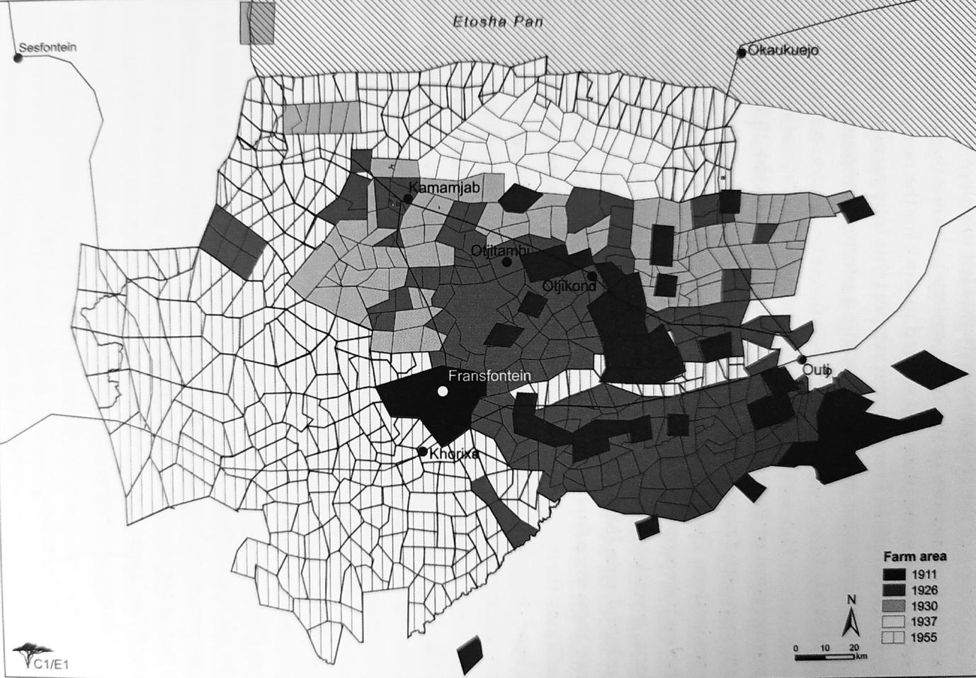
In the first meeting of the Legislative Assembly, Game Preservation Ordinance No. 5 of 1926 extends the list of protected game species: hunting licences had to be obtained from the Secretary for SWA[331]:
[t]his extended the list of protected game species considerably… Section 8 of this ordinance made provision for some form of management in that “every person who has taken out a big game licence … shall within one month ... furnish a return in writing showing the number, sex and variation of big game killed by him”. At this stage licence fees were 20 [36] pounds “for the killing or capture of not more than 16 animals”. The trade in ivory and rhino horns also now became illegal.[332]
Parmenus Zeraua, son of chief Zeraua of Otjimbingwe, is buried in Omaruru accompanied by ‘the emergence of the Otjizemba, or the troops of the black and white flag, in contrast to the red flag of the Herero of Okahandja’[333].
The prefecture of Cimbebasi is ‘elevated to become the vicariate of Windhoek, with no change to its boundadries’[334].
A skeleton excavated from the Lüderitz peninsula and accessioned into the Lüderitz Museum was considered to be that of the negress marooned there by Dias in 1486[?], but subsequent dating shows it to be of an elderly Khoisan man who died at least 240 years prior to Diaz’ voyage[335].
Beech (?Douglas Beach?) makes phonographic recordings of ‘some Khoekhoe’[336].
1926-1928
The boundary with Angola is shifted seven miles southwards leaving the former ‘Neutral Zone’ in Angola[337].
1926-1936
Establishment and building of a volkekunde department at Stellenbosch Univ. under leadership of Willi Werner Eiselen, the ‘architect of apartheid’ whose ‘German linguistic training under the racist cultural nationalist Carl Meinhof and already strident Afrikaner nationalist politics produced a detached for of ‘tribal ethnography’ driven by a quest to classify which was emphatically in the service of segregation from the outset.[338]
1926-1940s
Only official presence in the Kaokoveld was at Tshimakara / Swartboois Drift where ‘a lone white police officer cum native affairs officer concerned himself primarily with patrolling the Angola Border’[339], the primary concerns being ‘people trespassing over boundaries, sick livestock, poachers, smugglers’ and contraventions eliciting fines such as ‘one or two cows for … failing to report sick animals or migrating without obtaining permission’[340].
1927
Game Preservation Ordinance (Ord. 5 of 1927) repeals and replaces Proc. 13, 1921[341]. Farm Industry Commission and Land Settlement Commission reports, are again concerned with maintaining agricultural productivity[342]. Game Preservation Ordinance No. 5 articles 10, 11 and 25 prohibit hunting on crown land ‘with exception of dignitaries and officials on duty in rural areas’ and applies hunting restrictions on settler farms[343].
Major Manning, former Native Commissioner of Owambo, after having been transferred to Rehoboth reminds his successor Native Commissioner ‘Cocky’ Hahn, ‘of the urgent need to produce a game reserve report for Kaoko’[344]. In an undated correspondence from Hahn to the Administrator of SWA, and predating by some five decades later proposals for local people and ex-‘poachers’ to become ‘Community Game Guards’ (see below), Hahn details ‘a plan in which the headman Ikandwa, an “old and experienced ovaHimba hunter”, should act as warden of a game sanctuary on the Kunene where “a good class of tourists and sportsmen” could observe, photograph and hunt game within the reserve[345].
A census is made of the population of the three Native Reserves in northern Kaokoveld plus ‘Southern Kaokoland’[**?unclear where this is exactly] where ‘[t]he Herero’ settled there had ‘actively rebutted the administration’s plan to put them under the control of Vita Tom’, [27] and ‘Tjimba’ appear increasingly to identify themselves as ‘Himba’[346].
Male | Female | Total | |
Kahewa-Nawa’s Reserve = Kakurukouje / Kasupi’s successor) | |||
Himba | 188 | 200 | 388 |
Tjimba | 20 | 18 | 38 |
Total | 208 | 218 | 426 |
Oorlog / Vita Tom’s Reserve | |||
Herero | 54 | 62 | 116 |
Oorlams | 31 | 29 | 60 |
Himba | 234 | 363 | 597 |
Tjimba | 28 | 28 | 56 |
Total | 347 | 482 | 829 |
Muhona Katiti’s Reserve | |||
Himba | 158 | 155 | 313 |
Tjimba | 48 | 17 | 65 |
Total | 206 | 172 | 378 |
Southern Kaokoland | |||
Herero | 203 | 202 | 405 |
Oorlams | 17 | 3 | 20 |
Himba | 328 | 372 | 700 |
Tjimba | 196 | 228 | 424 |
Total | 744 | 805 | 1549 |
1927 census figures for the population of the three northern Kaokoveld ‘native reserves’ and ‘southern Kaokoland’. Source: Bollig 1997, p. 27 after Stals and Otto-Reiner 1990, p. 70.
South African Railways and Harbours constructs a water extraction plant at Rooibank on the !Khuiseb[347]. Topnaar living at Wortel / ǁGam-ams (‘watermouth’) where they were 'protected by the dunes from strangers’, move from here as ‘the area south of the bay was evacuated'[348].
Austrian anthropologist Viktor Lebzelter visits Etosha Pan ’in search of Bushmen’, but is dismissive of what he finds there as they wore European rags and, while not ‘missionized’. had adopted European names’, although also writing that,
[t]hey are always prepared to put on old (traditional) clothes and to dance for distinguished guests and allow themselves to be photographed. They are in the best sense Salonbushmen who are dependent upon foreign traffic. … [228] So for example one tried to sell me his “gun” (that is for practical purposes a worthless bushman bow) which he had bartered in the wilderness for a cup of sugar for one pound sterling. These Bushmen are really protection officials who watch over the game, but they are also volunteer police who catch all Ovambo who try to avoid the Pass controls at Namutoni. Generally they are still the most well-armed Bushmen…[349]
In February the Administrator A.J. Werth states in Chilvers’ The Seven Wonders of Southern Africa in which ‘the Bushmen are listed as one of the physical Wonders’,
that[w]e make no attempt to civilize the Bushmen. They are untameable ... The territory is so large and the Bushmen so cunning that an army might seek them in vain. But it is all fine country, splendid for sheep and cattle farming ...[350]
Amateur ethnographer Jan Gaerdes[351] ‘probably filmed some 800 meters … en route to the Kunene River’ where he visits Epupa Falls and the Baynes Mountains[352].
Late 1920s
There is concern in these years regarding associated with concerns regarding Truppenspieler (‘soldier playing’) / Otjiserandu (‘Red Flag’) activities in Kaokoland, through close contact with Herero factions in Omaruru and Okahandja[353], fed by Herero dreaming of ejuru – ‘that sky or heaven in which they envisaged a “historical landscape” ideal for grazing and settlement’[354].
1928
‘The native labour code of 1928 [Angola?] was largely abused and seldom enforced. Civil servants often recruited unwilling labour for both private companies and public works’.[355]
The ‘Prohibited Areas Proclamation’ 26 of 1928 (Section 3(2)) declares the Kaokoveld a game conservation area reserve, known, with the contiguous Etosha Game Park, as Game Reserve No 2, and covering a total area of 37,000 square miles (54,750km2); [33] ‘although the native inhabitants do possess firearms and are not prohibited from shooting any species’[356], Hahn idealises ‘the whole “uninhabited” north-western area as “naturally wild and full of romance”’[357]. Game Preservation Ordinance Amendment Ordinance / Proclamation 26 of 1928 re-proclaims Game Reserves 1, 2 and 3 and for the first time accurately defines their borders[358].
The area below the 19th parallel is ‘designated for whites’[359].
Through his work for the Boundary Commission, Hahn travels to the Kunene River between Ruacana Falls and Okuvare rapids, designating ‘“the old and experienced Ovahimba hunter headman” Ikandwa as informal warden’ resulting in ‘the replenishment of game’[360]. Hayes writes that:
[h]e wanted to transform the area into a sanctuary, which would offer “fine opportunities for tourists and sportsmen to shoot trophies under special licences and instructions”. This tied in with wider objectives of policing cattle movements in the area and an attempt to stabilise groups in reserves in northern Kaokoland to act as a buffer with Angola. Hahn argued that the administration should proclaim it a reserve and protected area, and run it on similar lines to the Kruger National Park. It was capable of surpassing the best game reserve in South Africa and creating “a real tourists' paradise in SW”. Game was disappearing elsewhere except in the Namutoni Reserve (Etosha), but “the flat and almost colourless country is not in any way to be compared with the wonderful variety and grandeur all along the Kunene.[361]
Hahn affirmed that the reserve would bring:
a good class of tourists and sportsmen who would have the opportunity of travelling through the whole of South West seeing and photographing game and its wildest and most natural beauty and procuring trophies under certain restrictions ... Sportsmen could indulge in the rather unique sport of crocodile shooting. The river teems with the brutes ... Tourists would bring revenue to the country as well as drawing attention to its possibilities[362].
In addition, ‘tourists paying for their supplies in SWA would help trade more broadly, thus:
I think experience has I shown that sportsmen of a good class actually assist in the preservation of game and such natural assets of a country[363].
Hahn even traced a rough itinerary for his imaginary tourists, starting in Tsumeb and proceeding to Namutoni. Here they would view and photograph game. Then, on their way to Ruacana, they would move from nature to natives, with a tour of the “tribal areas in O/land where wild natural life could be seen, studied and photograph (under special supervision)” [364].
Bollig and Olwage write that in this year ‘the last white commercial hunter was forcefully removed from the Kaokoveld’[365].
C.H.L. Hahn, Vedder and Fourie publish The Native Tribes of South West Africa, including information and photographs from Louis Fourie, then the Medical Officer for SWA[366], as well as a foreword by Secretary for SWA, H.P. Smit[367]. Bollig and Heinemann describe it as ‘a publication meant to satisfy the needs of the League of Nations for a credible report on the development of the native population in the mandated territory’, containing ‘18 pictures out of which some 10 are taken from Kaokoland’[368]. Groups seen as being most assimilated by European culture and costume, namely ‘Nama’ and ‘Damara’ receive little space and their diversity is smoothed through creating composite tribal identities[369]. The text becomes required reading for officials working in the SWAA Dept. for Native Affairs[370].
The bodies of South African soldiers killed in the former Neutral Zone, now Angola, of Owamboland in 1917 are disinterred and reburied at Odibo Angican Mission on the SWA side[371]. Kwanyama king Mandume’s body is left in Angola, although many Kwanyama believe Mandume’s head to be interred in Windhoek in a memorial erected to commemorate the SA troops who lost their lives in Owamboland in 1917, place at a small park at the entrance to the railway station passed by many contract workers from Owamboland[372].
Isaac Witbooi is leader in Gibeon from 1915 until this year[373].
Most of the remaining ‘Anglo-Boers’ ‘were moved to South West Africa by the South African government at their own request[374].
Hedley Chilvers, publicist for the South African Railways and Harbours, proclaims Bushmen as one of the seven wonders of southern Africa[375].
Diamonds are found on the southern bank of the Orange River, close to the coast[376].
The term ‘Khoisan’ is coined by Léonard Schultze, bringing together ‘two radicals’, ‘Khoi’, i.e. ‘person’ in Khoe, and ‘San’, i.e. ‘predator’, also in Khoe[377].
1928-1929
Botha remarks that:
scepticism was compounded by the fact that the Inspector of Lands estimated only about 64% of the Angola settlers were considered likely to make a success of farming. To make matters worse, the farmers had to cope with the effects of recession and drought, and additional expenditure had to be incurred to save many farmers from utter ruin[378].
1928-1933
Drought years[379].
1929
Anthropologist Isaac Schapera, student of Radcliffe-Brown’s at UCT, returns to UCT ‘to launch a fieldwork tradition in the region’, later taking over Radcliffe-Brown’s chair and credited with ‘that decisive shift in social anthropological method that allowed for the inclusion of colonial agents within the analytical framework.[380] The South African Institute of Race Relations, characterised by ‘liberal segregationist ideology’ is established under directorship of R.D. Rheinallt-Jones (friend of Winifred Hoernlé).[381]
Severe drought in north-west Namibia[382]. Outjo District (‘southern Kaokoland’) except for Franzfontein Reserve is cleared of people for the Land Resettlement Program through the forcible relocation of people northwards, so as to make the Police Zone border impenetrable for people and livestock[383]. A major portion of southern ‘Kaokoland’ Herero are forcibly removed northwards to central parts of ‘Kaokoland’, so as to make the Police Zone border impenetrable for people and livestock[384]. 1,201 people were removed in total (‘393 men, 448 women, 360 children’) plus 7,289 cattle and 22,176 sheep and goats[385], taking the population of ‘Kaokoland’ to 4,309 people[386]. 1,201 people are removed to more marginal areas in the Kaokoveld in total (‘393 men, 448 women, 360 children’) plus 7,289 cattle and 22,176 sheep and goats[387], at the height of the lambing season which meant that many animals perished[388]. Thus, for example, ovaHerero Headman Kephas Muzuma (born in 1910 at Okavao, now in the western part of Etosha national Park[389]) is moved with his followers
from the Etosha-Kaokoveld boundary area … northwards to Ombombo … when the colonial government created a stock-free corridor between ‘diseased’ African livestock and settler farms. This earlier forced relocation is still remembered as a terrifying event, one that exacerbated a lasting feud among different kin networks of Herero and Himba within Kaokoveld.[390]
Conducive conditions and state-sponsored immigration in SWA, combined with problems attaining land title in Angola, encourage Angola Boers (‘trekboers’/voortrekkers arriving from South Africa in 19th century who had farmed, hunted and traded in Angola) to trek through southern Angola into Namibia. Their return was negotiated by Prime Minister Herzog through church mediators and they were welcomed by ‘the Administration with an enormous fleet of modern transport lorries on the south bank of the Kunene river at Swaartbooisdrift’ and taken to districts with ‘empty land’ such as Outjo, Gobabis and Grootfontein[391].
The young (white) Gobabis farmers capture ‘fifty or so Bushmen’, burning down their huts and driving them westwards over night leaving them at various white farms in return for a small commission[392].
The Abbé Henri Breuil, whilst visiting South Africa, sees Maack’s copy of the ‘white lady’ rock art painting from the Brandberg[393].
Caprivi strip is added to the district of Grootfontein (Procl. 26/1929) [394].
1929-1930
The ‘famine of the dams’ in Owamboland[395] in which the colonial state responds by initiating a programme of dam digging for food relief[396]. Hahn abandons attempts to control African hunting[397], and severe drought elsewhere reverses processes of African livestock recovery that occurs following German rule and permits consolidation of the SA state[398]. Black workers and livestock frequently expelled from white farms[399].
1929-1948
Political structure in Sesfontein consists of a chief and four councillors, all Nama, who hold authority over Damara, Nama and Ovahimba residents[400].
1930
The government reportedly decrees that all farms should be fenced in[401], and surveyed farms are again expanding in Outjo District:
Expansion of surveyed farms in Outjo District. Source: scan from Schnegg and Pauli 2007, p. 13.
The first inoculation program undertaken by State Veterinary Office destroys approx. 18 animals, vaccinates 6,514 cattle, and recommends that cattle from Kaokoveld ‘be prevented from moving into the white farming area’, with ‘regular monitoring of waterholes along the 19th parallel by the police … [considered] sufficient to prevent the spread of the disease southward’[402]. Thus, in the SWA Annual Report of this year it is reported that,
[c]hanges in regard to the settlements of natives have recently been carried out in the Southern Kaokoveld. Scattered and isolated native families, particularly Hereros, have been moved to places where it is possible to keep them under observation and control. With few exceptions, these natives are well satisfied with the new localities. They also realize the advantage of being controlled by one chief. … All stock has been moved north over a considerable area in order to establish a buffer zone between the natives in the Kaokoveld and the occupied parts of the Territory which remain free of the disease [lungsickness].[403]
Additionally:
[t]he general health of the natives in the Kaokoveld remains satisfactory, although the shortage of food has been felt. The staple diet of the Herero is milk supplemented with meat when he can get it. Owing to the drought, milk has been very scarce and the natives have suffered in consequence. In the Kaokoveld, the natives in many localities grow pumpkins, beans, tomatoes, mealies, and a little wheat, but the quantities last year on account of the drought were less than usual.[404]
Regarding the policing of boundaries established by ‘Cocky’ Hahn in north-west Namibia, he writes in his report to the administration that the administration constable (Cogill) should be instructed to shoot Herero and Owambo cattle found transgressing these boundaries[405]. Unusually, a female German photographer accompanies a Herrensafari [see below] to the Kaokoveld, and photographs wildlife and people, especially women, in what is perceived as an ‘untouched native world’[406].
Donald Bain [see 1925-26 and 1936] guides the De Schauensee Expedition to Etosha where they film ‘Heiǁom’[407]. This was a bird collecting expedition,‘in the interests of the [Philadelphia] Academy of Natural Sciences’, that travelled from Cape Town via Windhoek to a number of places in west and north Namibia, including Etosha[408]:
Windhoek was a very pretty little town surrounded by high rocky hills, which are sparsely covered with small gnarled trees, but are quite bare of any sort of undergrowth. We were most kindly treated there by Mr. Smit, the Secretary for South West Africa. Through his interest we obtained permission to collect birds on the Etosha Pan Game Reserve and also to secure a limited number of the protected species. This enabled us to collect many interesting specimens, the majority of which were not in the Academy's collection
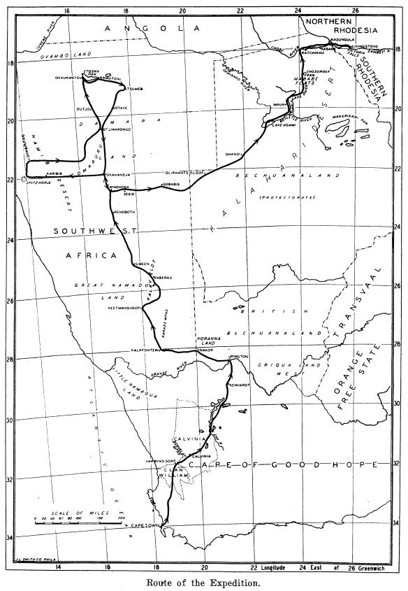
Route of the de Schauensee bird collecting expedition, 1932. Source: de Schauensee 1932: 146.
**to be contd.
In the south, South African hunters are reported to be indiscrimately shooting large numbers of springbok, taking the meat back to Upington[409].
Isaac Schapera consolidates use of the term ‘Khoisan’ (see 1928)[410].
1930-1932
The Solar Development Company prospects for minerals (specifically gold) at Zerrissene Mountain, west of the Brandberg and south of the Ugab[411].
1930-1934
Prolonged drought and loss of livestock[412].
1930-1960
‘[A] lot of fauna from the Congolese colony was added to the museum collection’ in Brussels, during these years[413].
For the very northern Epupa / Ombuku / Omuhonga area of Kaokoveld, after the southwards movement of Himba into this area after 1920, it is documented that grazing rotation and land tenure involved livestock camps moving ‘out to graze distant pastures during the rainy season when pans and other seasonal water sources offered enough water’, grazing ‘in orbits around these seasonal pools and once these rain-dependent water-resources fell dry, they had to retreat to settlements near permanent water reservoirs along rivers and permanent wells’[414]. Pastures further west were used only when exceptional rains filled ‘natural wells’ in the area[415].
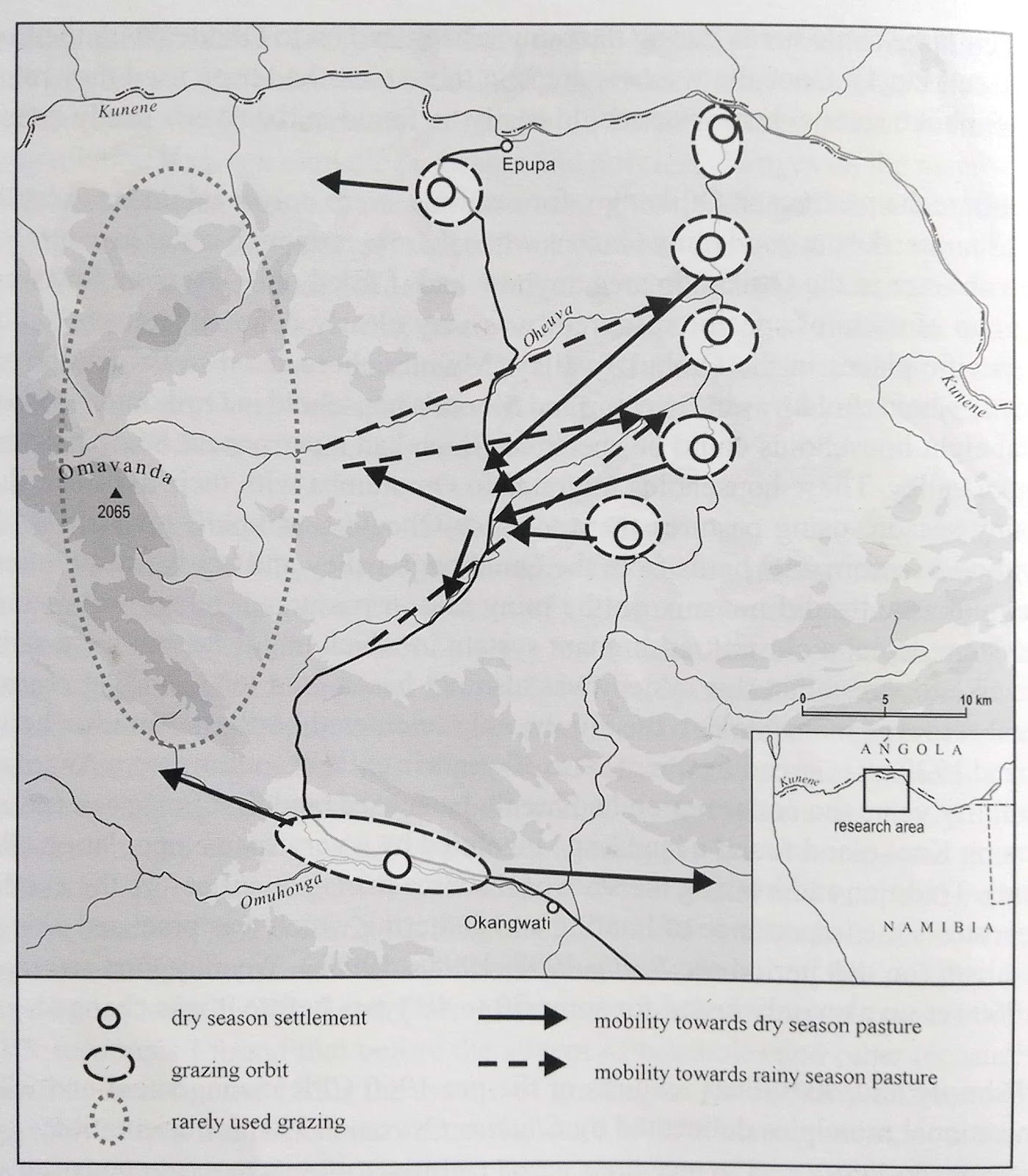
‘Pastoral tenure and mobility before 1960’ in Epupa / Ombuku / Omuhonga area of north Kaokoveld. Source: scanned from Bollig 2006, p. 42.
Early 1930s
By the beginning of the 1930s it became official policy to give preference to local applicants when farms were allocated[416].
1931
Kalahari Gemsbok National Park in South Africa is established on 31 July[417].
A year of ‘unforgettable drought’ causing some settler farmers to shift from cattle to karakul[418].
Constable F.G. Cogill [who had previously accompanied Manning in 1917?**] is instructed to travel on a special patrol to mouth of Owaruthe / Hoarusib River, leaving Ondangua on 19 November[419]. He touches on Sarusas and Omburo (Purros) amongst a long list of other places [??], arriving on the coast on 14 December, where south of the Hoarusib month he finds car tracks attributed, after being ‘told by Natives’ to a police officer who came from Kamanjab via ‘Zessfontein’ but had to return due to heavy sand[420]. Around 10 miles north of the Hoarusib he finds a vacated mining camp which the natives accompanying, from Omburo, state was ‘visited by the Kamanjab Police, 3 European and 1 Native, and the Headman of Zessfontein’ around 20 days previously, finding 4 white people here ‘with a small Boat… two Rifles, two spades, two picks and a Board on which was a name, also a sample Dish’[421]. Also found nearby is a further ‘Camping Ground, vacated about 2 years ago and Claim Pegs, with name Boards’ reading ‘Mr. Mc Mann, Precious Stones, Telegr. No. 20, dated 24/5/29’[422]. Cogill returns via Sarusas[423]. He reports that he sees little game in Kaokoveld after Epako[424]. At this time, ‘the Natives [‘very willing to assist me in any way’] who reside at Epako and Omburo state that they are subjects of the Zessfontein Headman and those at Otjinjande[?] … fall under Oorlog’[425].
‘Hei-2om’[?] is recorded for ‘Bushmen’ in the vicinity of Etosha Pan[426].
Vedder in this year publishes a text on ǁGaub, as quoted by Moritz:
“The Gaub farm is a very special piece of ground. On vegetation maps the farm is described as a tropical island. Huge fig trees, some of which grow on ancient omumborombonga [Combretum imberbe] trees, give a special character to the lovely terrain on which the farmhouse is built. Gaub is rich in water. In more than a dozen places, round knolls can be seen protruding from the terrain. They are old springs where the water flowed out, which seeped into the ground in the Otavi highlands.... Thus it came about that in Gaub in ancient times there was a large swamp in which the elephants cavorted, and in which the mosquitoes had a breeding ground such as there was hardly a better one in the whole country.”
Even today, old elephant traps can be found in the area. These are deep holes in the limestone, into which a pointed stake was driven. The hole covered with bushes, was a pitfall. Many an elephant had to lose its life on the way to the water. Vedder continues: "...at that time the Bushmen lived in Gaub, and they were served by the Bergdama."[??] A Bergdama led Vedder to an elephant pit and said, "Here in this hole I once stabbed an elephant with these two hands of mine." Vedder asked him, "And then you ate your fill of meat?" But he replied with a sad face: "I didn't eat any of it. I was in the service of my Baas, a Bushman [Kruger??], and he ate all the meat with his people and gave me nothing." Vedder continues: "But wasn't Gaub an old place of the mountain Dama of the Otavi highlands? No, it only became that later, when the missionaries of the Rhenish Mission sought reservations for the persecuted and afflicted Bergdama, who were enslaved by the Nama and Bushmen, beaten by the Herero, and who were outlawed from the Orange River to the Kunene River. At that time, the mission bought the farm Gaub. There they wanted to settle Bergdama and guide them to work and give them a secure life. Then, under the leadership of Missionary Kremer from Tsumamas, west of Outjo, they came to Gaub, and the others emerged from their hiding places in the mountain ranges of Otavi.... It was soon realized that it was too unhealthy to live near a swamp. Therefore, the Rhenish Mission sent a cultural engineer to Gaub, Herm Borchardt, who, at the turn of the century, drew up a plan for the drainage of Gaub. And because the learned Herm could say what had to be done, but could not do it himself, the same society sent the farmer Detering to Gaub, who built a house there and then proceeded to drain the swamp, but collected the water in a deep ditch and from there directed it to long drainage fields. When the German regiment in the southwest became stronger and the Bergdama also received the rights of a free man, it was no longer necessary to regard the farm as a reservation. Gaub became a heritage farm. A second farm was established at Gana-chaams and a third at the magnificent spring at Uris."[427]
Already under the guidance of missionary Kremer the Damara should be enabled to cultivate. Corn, pumpkins, wheat and tobacco were cultivated. Johannes Krüger, who married a Nama, spoke several languages and was considered a middleman among the various tribes. The Hei//om also finally recognized him as the supreme ruler of their territory. Krüger’s wife had grown up in the house of the Hälbich family in Otjimbingwe and had been brought up as a Christian. She spoke [18] good German and could also write.[428]
The German artist Hans Lichtenecker travels to Namibia to photograph, record, measure and cast people of the ‘vanishing races’ of South West Africa, working primarily in Keetmanshoop with people speaking Khoekhoekowab and oshiHerero who were summoned for study to the police station.[429] Lichtenecker had lived and worked in Namibia before and during WW1.[430]
Administration of the Caprivi changes from British Bechuanaland to South Africa[431].
On Christmas Eve, the ethnological museum at Wits, housing Hoernlé’s field notes, is burnt in a fire that guts the central section of the Wits Main Block[432].
The South African Entertainment (Censorship) Act includes a comprehensive list of potentially offensive features that if depicted inappropriately could lead to a film being banned[433].
1932
Natives (Urban Areas) Amendment Proclamation, builds on South African amendment of 1930[434]. Black entry into Windhoek is banned[435] and main location starts to be reorganised[436]. An ‘investigative commission’ is alarmed at the number of ‘poor whites’ living in mat huts[437].
By 1932 three mission denominations (Roman Catholics, Rhenish Mission, Finnish Mission) ran almost all the schools in Namibia[438].
A German Adulf Winter has idea of building a guano platform on rocks just below the surface of the sea, named ‘Winter’s Folly’ by disbelieving locals until a year later birds came ‘in their hundreds, in their thousands, cormorants, gulls, pelicans, flamingos, and scores of others’, providing an annual ‘crop’ at Bird Rock of ‘over a thousand tons of guano’ (containing around 16% nitrogen[439]) when scraped off by ‘boys’ in February-March[440].
The Uukwambi kingdom is bombarded by Union Defence Force aircraft in response to the Garvey-inspired anti-colonial activities of the king[441], and the headmen replacing the Uukwambi king Lipumbu ya Tshilongo display to van Ryneveld some of the deposed king’s store of ivory[442].
1932-33
Building of the Alfeus Haraseb Dam, now Daan Viljoen Dam: ‘[t]his was a very hard and difficult operation which was carried out with barehands. Men, women, and children did take part in this building operation which was completed before the great rains of 1934’[443].
1933
The International Convention for the preservation of African fauna and flora takes place in London, which Joubert argues resulted in Ordinance 19 of 1937 - see below.[444]
In Kaokoveld it is observed that:
[t]he wheat fields round the open water stood out in striking contrast to the surrounding country, and the natives were hard put to it to protect these against the elephants and other wild animals. Every night fires were built round the fields and the natives beat tins and shouted to keep the game off.[445]
The Truppenspieler movement is reported to be active in Kaokoland, structuring Herero contacts into ‘a system of fictive companies, flags and military titles’ that mimic those of the German Schutztruppe[446]. German colonists reportedly take down the South African flag in Windhoek[447].
1930s
First removals of ǂKhomani San from Kalahari Gemsbok National Park in South Africa[448].
The SA administration of SWA contemplates settling white farmers in the ‘neutral zone’ north of the Police Zone border[449], and in Caprivi designates West Caprivi as a livestock free zone, resulting in relocation outwards of Bantu language-speaking agropastoralists in the area[450]. Strict boundary controls protect the commercial farming areas, such that any move into Kaokoland requires ‘a pass from the local administration’ and ’Kaokolanders’ have to apply for passes to the police post at Swartbooisdrift / Tjimuhaka on the Kunene River, these applications then being sent on for approval ‘to the office of the Native Commissioner at Ondangwa’, and movement of livestock across international and internal boundaries is prohibited[451]. From around this time ‘a small elite of the settler community took delight in arduous safaris to Kaokoland’[452].
In the 1930s a Captain Nelson was appointed game warden at Namutoni “as an experiment” but was “dismissed after a few months”[453].
At some point in this decade the liberal scholar Moritz Bonn who had visited German Südwest Afrika, writes in exile of the connection between colonial experience and ‘the rise of Nazi totalitarianism’ that:
[Nazis] accept and amplify the racial theories by which General von Trotha had justified his policy of extirpating the rebellious Hereros by making them die of thirst in tthe Omaheke desert: - that according to the law of nature inferior races must die out when brought in contact with superior races. The Nazi creed is based on the same cheap conception of Darwinism, and like their colonial predecessors, they do not believe in the unaided working of this supposed law of nature[454].
A small expedition enters Nyae Nyae to map the border with the Bechuanaland Protectorate[455]. Hahn laments the Christianisation of Owambo peoples, especially through the activities of Finnish missionaries[456].
1933-34 rain season
Major flooding lasting four months of Swakop/Tsoaxau River at Swakopmund, where reportedly ‘hundreds of natives were put to building a clay wall’ – ‘Now the town is ringed in by a long sea wall and a flood wall on the desert side. It is strange to find a town with a rainfall of half an inch a year so heavily protected against water’[457]. A year of heavy rains in which the Kuiseb breaks its old course and floods Walvis Bay, leaving parts of the town under water for up to five months, floods wash away the bridge that crosses the Swakop mouth[458]. Köhler suggests from his field research in 1957 that following this flood the ‘!Nara nut based food basis of the Topnaar did not recover and since then plays only a minor role’[459]. As Moritz writes,
the flood had a devastating effect in the narafeld. Three women and one child were surprised and drowned while sleeping in the narafeld during the night. Others had to wait for help … A dead man was found standing in the mud. The evangelist Stevenson (Jakobus Argyll) told me that they had lived on Namariseb. The tide rolled away 25 sugar sacks and 2 large sacks of nara kernels. The hut was also a victim of the floods, and only with difficulty the people could be brought with ropes through the water.[460]
In Sesfontein this year is known as ‘Gâseb’ after the pastor Nicodemus Gâseb who died in this year when the rain was falling strongly, a year that also brought locusts (ǂhoms)[461].
1934
An Immorality Act is introduced in SWA, controlling intimate relationships along racial lines[462], a SWA Magistrate writing that,
[t]he personality of the person authorized to run the Bioscope is a very important one. The natives have impressionable minds and are in many respects like big uneducated children[463].
Subsidised by the SWAA, Rhenish missionary H. Vedder publishes South West Africa in Early Times in German, consolidating ‘Bantu’ and especially the ‘unspoilt’ ‘Bushmen’, rather than ‘coloureds’ or ‘whites’, as the appropriate focus for ‘ethnography’ and ethnographic photography[464].
Lebzelter publishes ‘a diagram of a Dama hut from the Erongo on which he depicts clay vessels used for storing water’ and ‘refers to these as ǁgamxawan (water vessel)’[465]. He also publishes a much reproduced list of !Geio / |Geio Damara leaders[466], as reproduced in Moritz[467], in which,
Lebzelter attempts to draw up a list of the chiefs (hoofmanne) [of !Geio / |Geio], calculating 25 years for one generation. Marriage took place relatively early. The eldest son was then considered the successor of the chief. The dates are the respective dates of birth, which then allow us to go back in history to 1390 (correction by the author).
[Cornelius Goreseb, Okjombahe - his successor was appointed in 1915[468]]
1. 1890 Hosea Goreseb
2. 1865 Judas Goreseb [died on 26.4.1923[469]]
3. 1840 Komelius Goreseb
4. 1815 Abraham Seibeb
5. 1790 ǁHoeseb (son of !Nawaseb)
6. 1765 !Gaoseb (uncle)
7. 1740 Tsauseb (the calf)
8. 1715 /Nawaseb (father)
9. 1690 Tsowaseb
10. 1665 Gariseb
11. 1640 Narirab (spear)
12. 1615 //Aruseb (monkey)
13. 1590 !Kudeb
14. 1565 ǂGoseb
1540 Uru-ge-//heib
16. 1515 !Owo-saub
17. 1490 !Hau- ǂkarib
18. 1465 ǂKari-/garub (young leopard)
19. 1440 Gei/garub (leopard)
20. 1415 Saub (grass seed)
21. 1390 !Ā-la-nanub
Hoernlé is promoted to Senior Lecturer in the Dept. of Bantu Studies at Wits[470].
The ‘strong organization’ of Hitler Youth is banned in South Africa[471].
1935
The Kaoko is represented by ‘Cocky’ Hahn to the Secretary of the National Parks Board as ‘the wildest and most inaccessible region of the country’.[472]
Detering at Gaub,
“had to sell 130 of the cattle in 1935 alone for 225 pounds sterling, because the pasture was very lean. For the caracul skins he got almost 1 pound each. 50 sheep were bought in addition with 25 lambs to better utilize the shepherd. Bush clearing continued to increase the cornfield.”[473]
[1]
Isaac Schapera describes Winifred Hoernlé as ‘the only all-round anthropologist we have in this country’.[474]
It is reported to the SWA administration that all known copies of the Blue Book 1918 have been destroyed[475].
The Windhoek Agricultural show features displays of ethnic, especially Owambo (orchestrated by Hahn), tradition, bringing ‘a varied group of Ovambo artisans and individuals to the Windhoek Agricultural Show’ with performances of men drumming and women dancing.[476]. Hahn organises a major ‘Tribal Meeting’ in Oshikango to mark an official visit of the Chief Native Commissioner and Marquis Theodoli, harnessing a pre-arranged efundula or female initiation[477].
A representative on the Location’s Advisory Board admitted to being a captain in a troop based in the Owambo section[478].
The SWA Commission expresses caution regarding further European settlement of land due to insecurity of farming[479].
mid-1930s
A bag-shaped, pointed base clay-vessel with unpierced lugs of similar style to that found at Gomatsarab is found in the Hungorob Valley and dated [in the 1970s or 1980s?] to 50±45 BP[480]. It is part of a cache 'consisting of metal tins (possibly old food tins), a tinder box and a possible cloth bag; a small crack on the lower half of the vessel had been repaired with a length of thick iron wire’[481].
Vita Tom of northern ‘Kaokoveld’ is ‘heavily fined for poaching’[482]. Increasing numbers of women are migrating southwards from Owamboland following experiences of colonial famine labour[483].
1936
A municipal beer hall is opened in Windhoek selling ‘weak beer to location residents at a profit, with the proceeds used to fund capital expenditure in locations’[484]. The Rhenish missionary Dr H. Vedder is based in Okahandja and subsidised by the Administration under Courtney Clark for the job of writing the history of SWA since 1892, to include Owambo expertise by C.H.L. Hahn and Manning[485].
‘Cocky’ Hahn, Native Commissioner of Ovamboland seeks to establish a Native Commissioner in Kaokoveld but is resisted by Oorlog Thom and subsequent Herero leadership[486].
The South West Africa Government Commission on ‘the future of the territory’ notes that the Damara population of 30,000 ‘have lived mainly by serving others’[487].
David Levin, who later [1947] acquires the farming area that becomes known as Twyfelfontein, leaves Ariesdrift / Alexander Bay area on the Orange ‘for South West Africa to by sheep with money saved’ from the family’s diamond diggings at Alexander Bay, buying ‘several sheep, a cart and two donkeys’ and travelling first to Nuichas, south of Goabeb, and working here for grazing and further sheep as a farmhand for the part-owner Dirk de Beer[488].
The Empire Exhibition in Johannesburg includes a much publicized exhibit of Bushmen brought by Donald Bain’s (“Bain’s Bushmen”), who are frequently depicted as encountering for the first time “the wonders of the white man’s civilization”[489].
1937
The USA passes the Federal Aid in Wildlife Restoration Act (the Pittman-Robertson Act), establishing the so-called North American Model of Conservation in which ‘purchases of guns, hunts and ammunition became the largest contributor of conservation revenue’[490].
Danish author Karen Blixen publishes her influential memoir Out of Africa, about her life as a colonial settler farmer in Kenya[491].
Inspired by the 1933 International Convention for the preservation of African fauna and flora takes place in London, the Fauna and Flora Protection Ordinance (Ord. 19, 1937) is gazetted, reading:
[t]o provide for the preservation of the fauna and flora of the Territory in their natural state … and to amend in other aspects the law relating to the preservation of game.[492]
Apart from protections of Welwitschia mirabilis, protected from 1916,
this ordinance now for the first time included the protection of plants. Enforcement of the game laws until then had been the sole responsibility of the SWA Police. This ordinance also permitted interested people to help with the applicable law enforcement in the capacity of honorary game wardens.[493]
Vita Tom (Oorlog) dies, afterwards a tribal council is created in the Kaokofeld, before this, the Kaokofeld resorted under the Native Commissioner of Ovamboland[494].
The apparently sole entry regarding women in Kaokoland in the archival notes is reported in this year, stating that ‘women should be prohibited from moving into the Police Zone and should not be given passes’[495].
Native Affairs officers station in Etosha report that the San / Haiǁom hardly ever hunt more than what’s needed for subsistence[496].
The veterinary / ‘Police Zone’ boundary is positioned in the north-west as per map below:
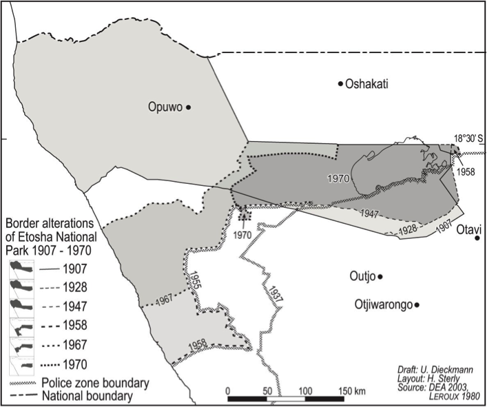
Surveyed farms are again expanding in Outjo District:
Expansion of surveyed farms in Outjo District. Source: scan from Schnegg and Pauli 2007, p. 13.
Wilhelm Detering’s son Karl marries and takes ‘over his father's position in Gaub’, his parents retiring to Germany then returning to ‘their beloved Southwest Africa’[497]. Hermann Eickmeyer, who had come as the second missionary farmer to Gaub in 1912, writes in a report of this year that,
"[w]e had planted our corn at the right time, but since the rains failed to come, it could not come up. Then when the rains came at the end of January, it was 3 weeks too late. If the frost had come late, the damage would not have been so great, but since the opposite happened, most of our corn froze to death"[498].
The ‘Mandume Memorial Committee’, consisting of Christianised Oshiwambo-speakers living in the Windhoek location, acquire permission to lay a wreath at the memorial to the fallen SA soldiers in Windhoek (see 1928 above).
1937-38
Inoculation campaigns against lung sickness in Kaoko institutes a period of successful establishment of SA administration in the region through these campaigns as an instrument of rule in conjunction with a headman council system[499].
1938
A large group of ‘Damara-speakers’ are removed from Windhoek to farms and reserves[500]. A group of people ‘described as Ovambo and accompanied by Ovaherero and others’ are required to leave Otjeru, ‘a settlement between Outjo and Omaruru granted to them under German colonial rule’, oral traditions relating that ‘their captain, Lazarus Amporo, sent a message to Petrus Swartboois, the head of the Fransfontein Reserve Board and leader of the Swartboois, asking to grant his people refuge in Fransfontein’, Swartboois also petitioning ‘the colonial administration to significantly extend the boundaries of the Reserve’[501]. The ‘colonial archives’ instead relate that ‘the extension of the Fransfontein Reserve that was granted at about the same time but not to accommodate the ‘Ovambo' settlers but to make space for Nama from Grootfontein and Walvis Bay’, the ‘friendly welcoming of Amporo … reflected by his appointment as a member of the Reserve Board in which he represented the newcomers’, the Bantu speaking arrivals mostly settling on posts south of Fransfontein[502].
The ‘Mandume Memorial Committee’ of Windhoek (see 1937 above) is refused permission by the Location Superintendent to lay a wreath at the monument to British soldiers/SA troops who fell in 1917, on grounds that commemorating Mandume is inappropriate at this site (given no awareness of the Kwanyama belief that Mandume’s head is interred at the memorial[503].
Vedder’s South West Africa in Early Times is published in English in a slightly condensed version.
During WW2, Abbé Breuil returns to South Africa and after examining more recent photographs of the ‘white lady’ rock painting from the Brandberg writes to prime minister General J.C. Smuts requesting transport to study the site (not granted)[504].
1939
The SWA Administration passes the Natives Trust Fund Proclamation No 39 of 1939, establishing the Herero Tribal Trust Fund, the Nama and Dama Native Trust Funds - so far, 17 ‘native reserves’ (23000 square miles) had been created[505]. Kaokoveld becomes a separate magisterial district with a Native Commissioner - an Officer in Charge of Native Affairs - stationed at Opuwo / Ohopoho[506]. Under the supervision of ‘Cocky’ Hahn in Owambo, who with his family by this time ‘had their own reed thatched camp at Ohopoho near the airfield’, this Officer was particularly involved with veterinary inspections related to lungsickness[507]. Hahn was increasingly involved with taking aerial photographs of the region[508] and the first aircraft landed in Opuwo in this year[509].
It is observed that ‘[t]he Zesfontein residents take great interest in their gardens and barter their surplus wheat and tobacco for other necessities’[510]. Elsewhere in Kaokoveld, pressure on gardens by elephants is noted:
[w]ith a few exceptions, the Hereros have lost interest in agriculture as the elephants have repeatedly destroyed their crops. The problem of how best to prevent this in future is no engaging attention. It is rendered complicated by the fact that the northern and central portions of the Kaokoveld fall within a Game Reserve; that elephant there are estimated to number anything from 1,000 to 1,500 and that it is the administration’s policy to protect these animals.[511]
By this year, pastoralists in Kaokoland had been subject to such severe punishments for mobility that they regard it as obligatory to obtain a permit in order to move their cattle, and around this time and into the 1940s it was customary to ‘liquidate’ herds found crossing into or from Angola[512].
Hahn writes in monthly reports to the SWAA that native administration in Kaokoland should follow that established in Owamboland, namely ‘indirect rule’ through which ‘rank and file are controlled through their traditional leaders’ whose status and influence must thereby be upheld[513].
Damara people are removed from the Windhoek Location[514].
With WW2 Karl Detering of Gaub is interned and his father Wilhem can not return to Germany[515].
David Levin [see 1936] is joined at Nuichas by de Vries (see above) where Levin and his wife Ella née de Beer remain as bywoners (‘farmers living on someone else’s land’)[516].
Hoernlé is made an Honorary Fellow of the Royal Anthropological Institute (London) but resigns from her senior lectureship around this time, apparently ‘to devote more time to practical issues ofpublic life, welfare work, questions of penal reform, race relations, and the improvement of non-European education’[517].
After much legal representation a ‘coloured’ man in Luderitz is the first person in SWA to be granted a bioscope license to show films here[518].
1939-1945
Second World War. Hahn is in service in SWA for the British[519]. Namibians are recruited into Native Military Corps[520].
1939-1940s
Africans including ‘BergDama’ are repeatedly and forcibly moved out of the western areas between Hoanib and Ugab Rivers, although inability to police this remote area means that people move back as soon as police presence has left[521].
1940
Union of South Africa settlers in SWA receive ‘call-up instructions for military duty on the African Front’, and service later enables veterans to purchase available land in SWA at a reduced rate of 3d / hectare[522].
The native commissioner of ‘Ovamboland’ and acting game warden of Etosha Game Reserve writes of the Haiǁom in Etosha to the secretary of SWA that,
I do not consider the Bushmen population of the Game Reserve excessive; in fact I thought that room could be found for more wild families and that these could be settled at places other than the main springs and game watering places, where big concentrations of various species of game even proved so attractive to visitors. I pointed out too that the Bushmen in the Reserve form part and parcel of it and that they have always been a great attraction to tourists.[523]
In southern Angola many Kuvale are ‘shot by the Portguese army because they allegedly rebelled against the colonial order’[524].
Early 1940s
A Council of Headmen as a ‘joint tribal authority’ is established by Native Commissioner Hahn ‘to adjudicate cases and to make contact with the colonial authorities in monthly meetings’, and ‘to balance the different power groups of Kaokoland’[525]. Aerial policing is used to discipline the Ndonga king Martin ka Dikwa who was reclaiming the right to try murder cases in his customary court[526]. Large herds of livestock crossing the Kunene ‘illegally’ are culled several times by the authorities[527]. Around this time a Damara family led by Petrus !Ganeb moves to north of Fransfontein settling at !Ganeb Pos / Tsaurob (meaning ‘the small water hole’[528].
1940s
= recruitment for the Native Military Corps from Owambo [**cf. photo of Senior Headman Ehrens Gurirab’s brother..].
The League of Nations collapses during WW2[529].
The SA administration contemplates ‘resettling all Herero from the Police Zone’ to the ‘neutral zone’ of southern Kaokoland, north of the Police Zone boundary[530]. Hahn forbids Himba from settling within 10 miles of the Kunene[531].
Herds in African Reserves are restricted to 100 large stock and 300 small stock (per family?)[532]. A welfare officer for the Okombahe Reserve requests to be able ‘to shoot ostriches, zebra and springbok throughout the year, and to distribute the meat to schoolchildren and indigent people’[533].
Schlettwein owns Warmquelle until the 1940s, when the Administration exchanges Warmquelle for Kaross, since Warmquelle was outside the Police Zone[534].
1940s-Odendaal
From From the 1940s until Odendaal,
Muzuma’s group [i.e. ovaHerero Headman Kephas Muzuma, see 1910, 1929] negotiated with Headman Joel Tjijahura for grazing and waterhole access from Ombombo to Oniaso [sic - Onaiso], also making use of remote grazing in the mountainous area above the Khowarib Schlucht. Throughout this period people and stock crossed into unfenced Etosha for a variety of reasons:
“There were traditional uses in the park - [the people] lived there, grazed their cattle and they hunted and traded with other indigenous peoples occupying parts of the park - they hunted oryx and giraffe and traded with the Ovambo to the North who had gardens - e.g. giraffe rumens were traded to the Ovambo who used these for clothing items and water gourds.”[535]
1941
Government Notice No. 42 adds 200 ‘qm’ [sic?? – should be km2?] to Zesfontein[536]. Nathanael Husa |Uixamab, chief of Sesfontein dies after being mauled by a lion, leaving no issue; the Sesfontein Nama leadership goes outside of the hereditary line to Benjamin Mîn-ǂhab Kido, son of the RMS evangelist Nicodemus !Naistab Kido and his wife Kristina, who had come to Sesfontein from Franzfontein (see 1898 above)[537]. He is appointed in an acting capacity [until 1942] because of his ability to read and write, even though he was a spiritual leader from the Swartboois[538]. A herd of around 500 cattle is ‘shot near Otjinungua’ and border posts are established ‘at the main fords across the Kunene river’[539].
The administration employs two Native Guards to patrol the Caprivi Strip and its borders, ‘keeping it clear of “natives” and livestock’[540].
South Africa’s minister for native affairs, Colonel Denys Reitz, comments that ‘it would be a biological crime if we allowed such a peculiar race [the Bushmen] to die out, because it is a race which looks more like a baboon than a baboon itself does ... We look upon them as part of the fauna of the country’[541].
1942
Anthropologist Max Gluckman, student of Isaac Schapera, becomes second director of the Rhodes-Livingstone Institute in Zambia, and influences Manchester School which ‘is alleged to have pioneered the study of ethnicity and urban anthropology’.[542]
The SWA Administration starts awarding grazing licenses and [14] rumours are ‘rampant’ that the SWA Administration has ‘proclaimed land in the Kaokoveld (Damaraland) for farming under the grass licence scheme’ allowing farmers ‘to settle not less than five miles (8 kilometres) from one another’ for an annual licence fee, and that following survey of the land they would be ‘entitled to purchase it at a price that would be determined’[543]. Landless farmers could apply, some using war veteran’s certificates to assist with acquiring land, precipitating a trek northwards of those with the means of moving[544].
In ‘Kaokoland’ a ‘comprehensive enumeration‘ registers 5,173 people[545].
A Captain Smith leads ‘the expedition which rescued the castaways of the Dunedin Star’, driving his convoy ‘along the Hoanib River course in the process of which every single vehicle became bogged down in the thick sand’[546].
1942-1978
Simon Petrus Kaira ǁHawaxab takes over the Sesfontein leadership succeeding Nathanael Husa |Uixomab, because Husab did not have a son who could fill the position, and Simon Petrus ǁHawaxab was brother-in-law of Husab[547]. Upon assuming his duties as Traditional Leader, Simon appointed other traditional councilors to assist him: Urimunka Kasaona, Hivetira Karutjaiva and Mitjiranga Uararavi representing Himba people, and Levi ǁHoeb and Elia Amxab representing the Damara people[548].
1943
Anthropologist Winifred Hoernlé is honoured with the unoffical title of the ‘Mother of Social Anthropology in South Africa[549].
‘Cocky’ Hahn is sent by South African authorities in Windhoek on an expedition to the mouth of the Kunene River ‘to investigate a number of illegal diamond prospectors operating without government permits’[550].
Jacobus Christian, Headman of the Bondelswartz Reserve, dies[551].
An Afrikaans text Jagkonings by Von Moltke is published conveying Boer hunters in Namibia, Botswana and Angola[552].
SWANLA (South West Africa Native Labour Organisation) is founded[553].
1944
African reserve dwellers in Otjohorongo Reserve complain bitterly that ‘thousands of springbok’ are destroying the grazing and request the welfare officer to drive these animals away[554].
Outjo becomes a municipality[555].
1944-1948
Drought years[556], causing farmers to trek for grazing with their livestock, for example, ‘north to Soris’, ‘a farm in the north-west’ from near Omaruru, on a farm purchased by German settler farmers[557].
1945
The Damara Reserve of !AoǁAexas (Aukeigas) is deproclaimed ‘to rid Windhoek and |Khomas Hochland from Damara influence’[558].
Wilhelm Detering of Gaub dies on 8 September and is buried in the cemetery in Grootfontein, ‘where on the gravestone the year is given as 1943’[559].
[1]
In the wake of 1945 ‘the Hereros were given marching orders … by the Baster Raad [Town Council]’, meaning that the |Gaiodama Dax / Taks (see above), Kanaangure, Tjienda, Kazohona, Kamburuzue, Haman and many families regarded as of Herero origin were pushed out to Aminuis’, although managed to go back to Rehoboth later[560].
Mudumu and Mamili (now Nkasa Rupara) hunting reserves established in Caprivi, later becoming National Parks[561].
1946
Endorsed by the white Legislative Assembly (in SWA), Smuts seeks to incorporate Namibia into South Africa as a fifth province, a move defended to the League of Nations as in the name, and on the behalf, of the people of SWA, and, once rejected, initiating a process of withdrawal from international supervision[562]. ‘Cocky’ Hahn ceases to be Native Commissioner of Owambo.[563]
Tourism in Etosha begins to be promoted:
From Otjiwarongo the next stop is at Outjo. Here the traveller will obtain a permit to enter the Game Reserve. En route to Okaukuejo the traveller may encounter elephants at Ombika, a water hole. No visit to the Pan is complete without a journey to Namutoni. It lies 80 miles to the east and the road, though little more than a track provides fair going. Shades of 'Beau Geste'will be conjured up by the first sight of Namutoni. An old white-washed building in French Foreign Legion style, complete with tower and embattlements.[564]
For the post-WW2 period Rizzo describes ‘the genesis of Kaoko and its tribalized [‘untamed’] population as a consumption asset for the southern African settler societies’ - modern, white, industrialised .. incl Namibian settler societies[565].
Regarding the potential export of wheat, mealies and tobacco from Sesfontein (‘Zessfontein’) to markets in the Police Zone, this will not be approved by the official concerned, ‘unless he could be given the assurance that the natives of Zessfontein are completely isolated from the rest of Kaokoveld’, otherwise there would be the danger of spreading foot and mouth disease from Sesfontein to the Police Zone:
[c]onsiderable hardships have been imposed on the Zessfontein residents by prohibiting export of their cereals, as they are now unable to purchase their supplies and needs such as coffee, tea, sugar and clothes etc. to which they have become accustomed[566].
The Census indicates that only 8% of (settler) farmers have an annual income higher than £1,000 and only 12% higher than £500 and wildlife appears to be an important source of food[567].
David Levin, the settler farmer who acquires Twyfelfontein, applies to the Land Board in Windhoek ‘for grass-license land in the Kaokoveld’, having been a bywoner at Nuichas in southern SWA, [16] travelling with his animals in trucks[568]. He requests “the piece of land with the spring south of the Aba-Huab River … before it intersects the Huab River”, the Damara name for which was |Ui-ǁaes (as apparently ‘marked on the map’), claiming that ‘though the piece around the spring was small, the entire Namib around it was uninhabited’[569]. Initially refused on grounds that the administration could not support people settling at places they could not survive in, but permission received to visit the area[570]. With Dirk de Beer who settles at Dobbelsberg/Gamble near Wilhelmstahl they go looking for |Ui-ǁaes spring, speaking with Andries Blaauw, of the neighbouring farm that becomes known as Blaauport, who relates that he himself ‘was considering moving his sheep there during the winter’ although he ‘doubted if there was sufficient water for 200 animals’, and mentioning ‘that a Damara family lived there with some of their animals’[571].
**include images from Blaauport in the 1990s**
When Levin and de Beer visited the spring they found it ‘dotted with goat spoor’ and ‘observed the Damara family’s hut and kraal across the dry riverbed that passed through the valley, about half a kilometre west of the spring’[572]. The Damara family was headed by a man called Elifas and although they had difficulties communicating they understood that he ‘did not live there permanently, but moved there when grazing at Grootberg (Big Mountain) was depleted’, and who ‘also spoke of Gwarab, most likely the Khowarib River near Warmquelle’[573]. When Levin and de Beer camp near that night they heard hyena and jackal, and travelling west they observe ‘plenty of grass covering the plains’, noting that ‘[t]he people [i.e. settlers] on the farms [nearby] welcomed their visitors and the prospect of David [Levin] and his family settling in this remote part of the Kaokoveld’[574]. Further south, driving from Sorris Sorris to Okombahe they observe that this is ‘a reserve for Damara people’ where ‘there was almost no grazing’[575].
Levin announces to the Land Board that he is moving to |Ui-ǁaes (although trouble could be expected when ‘settling on undeclared land’) and requests ‘a herder at the representative for South West Africa Native Labour Association (SWANLA), which was responsible for recruiting farm-workers from the Owambo and Kavango regions for 12 to 18 month contracts’[576]. In November he leaves Dobbelsberg / Wilhelmstal ‘with his sheep and four donkeys, named Vaaltyn, Bloudon, Ligman and Witbooi, heading for Spesbona [at eastern foot of Erongo Mountain, where Kerneels van Niekerk lived, p. 18]’ his six-year old son Michiel and herder ‘Jeremia, a Damara man from Karibib’ (who left soon in 1947), Bernhard, a Damara worker at Spesbona becoming his ‘right-hand man’ pumping water, looking after kraals, and skinning and preparing karakul pelts[577] [contd. 1947 below].
The property of Daniel De Pass & Co. in Hottentot Bay is sold to the Table Bay Canning Co. to carry out fishing and sealing[578].
1947
Karakul pelts, an important export for SWA’s settler farmers, are auctioned in Hudson Bay, Canada and later in New York and other major cities[579].
Kaokoveld is proclaimed as a native reserve (the Kaokoland Reserve) with Opuwo as the administrative centre, bounded by the Atlantic Ocean in the west, the Kunene River in the north, the Ovamboland Native Reserve in the east[580], and appears to be part of the western extension of the Etosha Game Park in the south, which at this time follows the 1907 boundary of Game Reserve no. 2[581], i.e. along the Hoarusib. Although perceived to mean that the former Game Reserve status of his area has been degazetted[582], it is not clear that this is formally the case[583].
Andries A. Pienaar,[584] an author ‘who wrote adventure stories set in the wild’ (known as Sangiro), is appointed as the first full-time additional game warden (to the Secretary of State as the Game Warden for the territory), stationed in Otjiwarongo and in charge of Game Reserve No. 2 which had previously been managed by the Native Commissioner stationed at Ondangwa[585].
The Abbé Breuil reaches the ‘white lady’ painting in the Tsiseb ravine of the Brandberg, romanticising the location as conveying an impression ‘of a great fallen acropolis’[586]. He is visited by then Administrator of the territory, Colonel Hoogenhout, and they agree (with Smuts on seeing Breuil’s new copy) that this is ‘great art’, not ‘Bushmen art’[587].
In February the Levin family treks north (from Spesbona, Erongo) to claim the farming area at |Ui-ǁaes, [9] renaming this as Twyfelfontein by David Levin (son of a retailer of Jewish descent a who had emigrated from Lithuania via England in 1899, who previously had ‘made a living mainly as a hawker in the rural areas of Springbok’)[588]. When they arrive at |Ui-ǁaes – their track becoming the road to Twfelfontein - the Damara family of Elifas was ‘still west of the spring’ and a bell-tent was erected ‘next to a mopane tree, about 100 metres from the spring’ for the Levin family[589]. With his Damara worker Bernhard translating, David learned that,
Elifas did not in fact live at the spring. There were apparently other springs in the vicinity, one being at the great mountain (Grootberg) where he was told palm trees even grew, and a second one in the Huab River. Elephants and lions visited the reed-lined Huab spring. The lions, in particular, posed a problem for them. Elifas was interested in David’s Mauser. “Could you shoot them?” he enquired.[590]
‘With Bernhard interpreting, David was able to enquire when Elifas intended to leave the area and discovered that he was planning to depart soon’[591]. Elifas assists Levin as he sets himself up with his [24] ‘230 sheep and goats, six chickens, two horses, four donkeys, a horse cart, a donkey wagon, a square tent and some basic household items’[592]. He also shows David Levin ‘how to dig up ants nests and harvest their grass seed stocks, which the ants accumulated as winter food, and how to cook the seeds into porridge’ but ‘[b]ecause this porridge tasted of soil … Ella [David’s wife] seldom prepared it’[593]. The high cost of ammunition and lack of fridge meant that the Levins rarely killed ‘game’ animals and it is reportedly only later ‘that farmers in the area … killed large game’[594].
In May Levin is visited by a police officer informing him ‘that as he had no license, he was illegally at the spring’ and given an ultimatum, ‘obtain a license at the Land Board office in Windhoek or leave’[595]. At this point, ‘[t]he Land Board was encouraging farmers … by granting them loans to drill for water and construct reservoirs’, and following meetings with a neighbouring farmer (Willie Esterhuizen from north-east of Twyfelfontein, on a farm that became part of Blaauwport in 1952) [27] is eventually granted a grass licence for which Levin ‘would have to pay the license fee at the magistrate’s office in Outjo within six months’[596]. The name 'Twyfelfontein' – ‘doubtful spring’ arises from Levin's neighbour, Andries Blaauwpoort, frequently seeing Levin at the spring saying he doubts it will make the next rains[597]. Levin has to move with his sheep and goats for both grazing and water, going to a ‘post’ at Swartpoortjie just north of |Ui-ǁAes and camping just north of the reed-lined water (De Riet) on the ǁHuab, uninhabited at that time, which was used by Levin, Andries Blaauw and Willie Esterhuizen, as well as by elephant[598]. Levin brings reeds from here to help with building a hut at |Ui-ǁaes[599]. The stone reservoir built by Levin below |Ui-ǁaes is still there. Farmers’ co-operatives collect karakul pelts from farmers such as Levin to sell in auctions worldwide, [40] assisted in Levin’s case by Damara labour[600]. At this time banks offer farmers little credit but retailers would usually sell household essentials ‘on the book’ so that they could bridge ‘cash flow shortages between lamb harvesting seasons’[601]. Goats occasionally were bought by speculators to be sold for meat following slaughter in abattoirs in Windhoek or Swakopmund and animal products were sometimes exchanged for household items[602].
**insert images of dam etc.**
Twyfelfontein farm as acquired in the late 1940s and 1950s by settler David Levin and family. Source: scanned from Levin and Goldbeck 2013, p. 28.
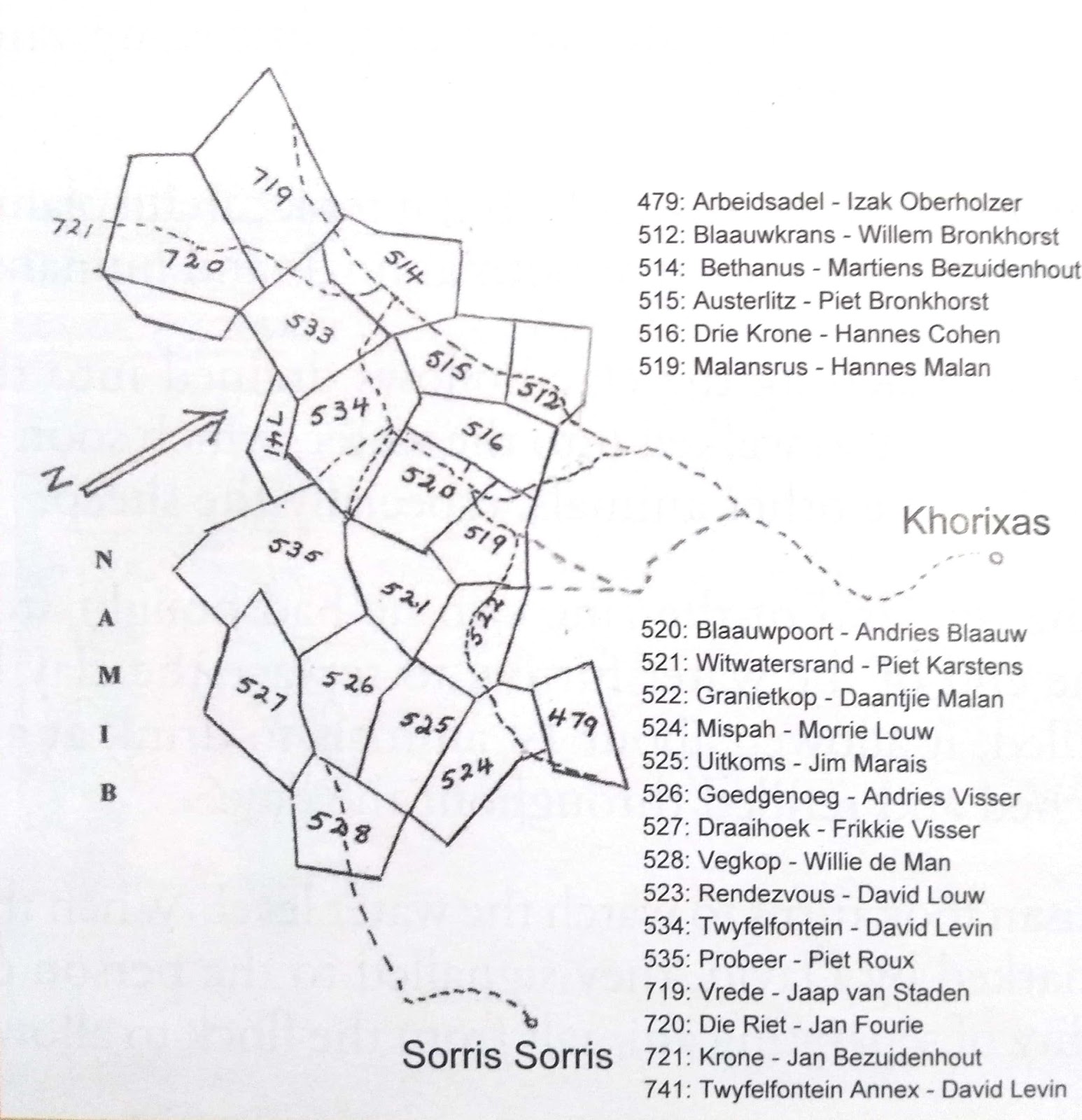
Farms surrounding Twyfelfontein (no. 534) in the late 1940s-1950s. Source: scanned from Levin and Goldbeck 2013, p. 30.
Over the years the farm is visited informally by people interested in the rock art here that later [2007] warrants its designation as a UNESCO World Heritage Site[603].
Primitive accumulation of land, ‘improvements’ and stock - south of vet fence / southern ‘Damaraland’
_ from farms to ‘wilderness’
The Administration ‘commences a scheme to bring the “Bushpeople” under greater “protection” [67] and in this year “Bushman guards” are ‘installed at San settlements in the Kavango region to maintain law and order, protect game, protect Bushmen from other blacks, and encourage them to become sedentary, adopt agriculture and practise animal husbandry’[604].
A court case this year (Rex v. Maharerro and twenty-three others) finds 24 Herero-speakers,
guilty of cold-bloodedly massacring thirteen Bushmen: two males, four females, and seven children in the erstwhile Waterberg-East Reserve. The ostensible cause for the massacre was that a Herero had been killed by a Bushman arrow while on a fifteen-man mounted commando trying to recover some cattle allegedly stolen by two Bushmen. The next day, a commando of between twenty-six and forty-five Herero, mounted on horses and donkeys, set out to exact retribution. They managed to surround [xi] the band of Aeeing Bushmen, and while those on horseback patrolled the periphery to prevent escape, the donkey brigade dismounted and went in for the kill on foot. Using clubs and assegais, they ripped open stomachs and severed hands. In this well-planned and cold-blooded atrocity, not a single Herero was wounded. Three Bushmen males managed to escape. The three men who escaped were later murdered, but the State did not have enough evidence to charge anybody for these crimes. Indeed the Administration discovered this massacre by accident. In passing sentence, the judge commented on the unsatisfactory nature of the evidence given by the accused, and indeed later two of them were convicted of perjury. Outraged Herero promptly but unsuccessfully appealed the seven year imprisonment sentences. A year later, that great champion of Namibian liberation, Chief Hosea Kurako, personally led a deputation to the Administrator asking for the release of the prisoners on the grounds that they had already suffered enough for their misdeed! The horrifying aspect of this Waterberg Massacre was that in 1983 when I visited the area to try to collect oral histories on this event, no one could recall it. It was as if it had been expunged from the collective memory. …[605]
1947-1948
Van Warmelo conducts ethnographic research in Sesfontein and Kaokoveld at which time ‘Sesfontein itself is only occupied by the settled community living there[606]. ‘Schlettwein’s farm ‘Warmbad’ is occupied by one of the Sesfontein Nama ‘voormanne’ - Jafta Hendrik - ‘with a small number of people’[607]. Grazing posts are used in the area around Sesfontein itself ‘for many miles around’ and:
Sesfontein itself is only occupied by the people living there .... The Sesfontein people make use of the grazing for many miles around and have a few posts for their cattle. A number of Herero, Himba, and Tjimba live a semi-nomadic life in the country north-east and north-west of Sesfontein and these also form part, in a loose sense, of the Sesfontein social and economic unit. There is a sort of no-man’s land zone around the Sesfontein sphere of influence which integrates these cattle nomads with the oasis dwellers. The unit is thus much larger than the reserve.[608] … [extending] as far north as Purros and as far south as the mouth of the !Uniab River, and included most of the territory in between[609].
Van Warmelo notes that ‘[a]dministratively the Sesfontein community forms a self-contained entity apart from the rest of the Kaokoveld’ describing the ‘traditional leadership of the old Hottentot “kapteins”, a hereditary position’ as ‘weakened’ to the extent that a non-family member was appointed as leader / senior Headman [see above], with a small number of ‘Sub-headmen’ recognised by the government as assisting him[610]. Although having the right to participate in the Council of Headmen of the Kaokoveld, van Warmelo states that ‘they would probably never dream of doing so’ since they would not ‘concede the right to decide about Sesfontein matters to any but the government’[611].
Regarding Sesfontein’s history, Van Warmelo asserts that:
‘[t]he earliest occupation of Sesfontein was probably by the ubiquitous Bushman, of whom, however, little trace or record remains. He was ousted long ago by the Bergdama, and these were in turn subjected by Herero cattle nomads from the north. These two lived together in a symbiosis already familiar from elsewhere in South West Africa, the Herero being the acknowledged masters and living on their herds, the Bergdama hunting, collecting and working for them. Some Himba relate that the last Omuhimba to lord it over Sesfontein was a man named Omusema.
This state of affairs ended with the arrival of the Hottentots who are now the dominant element at Sesfontein. Two groups of them arrived, at different times. The first or largest were !omen or Topnaars, the later arrivals were a small group of ǁkou-|gõan or Swartboois.’[612]
In addition to the Nama, mostly !Gomen / Topnaar leadership, whose history of arrival Van Warmelo describes as well as including a geneaology of the Nama leadership at the time of his field research and a photograph of a reed mat ‘Topnaar hut’ in Sesfontein (Plate 12), Van Warmelo briefly describes other ‘groups’ in Sesfontein as follows:
- ǁKou-|gôan or Swartboois present in Sesfontein had come from Franzfontein where they were a part of the group living under the leadership there of Cornelius |Hoân-|arab Swartbooi[613].
- ‘Bergdama’, in spite of being the most numerous people in the settlement at the time of Van Warmelo’s visit, are described in the following brief sentence as:
‘[i]n the course of time the Bergdama who had been driven out of Sesfontein slowly came back and were allowed to make a living there under sufferance’[614].
- Herero he describes as being very few in Sesfontein at the times of his visits saying that:
‘[t]hose few resident in the vicinity live, like the Himba, a pastoral life and take little or no part on the life of the Sesfontein oasis itself’[615].
- of Bushmen he has rather more to say, despite there being ‘only a few Bush people left’, as he puts it[616]. He says that he could only interview ‘one old man named !hu-!gaob who had come in to Sesfontein for the reaping of the wheat in the hope of getting something, for the Sesfontein people appear to be kindly towards the Bushmen’ (possessing no bows and arrows, having last used them as a boy[617]), accompanied by ‘a young man called |nanimab, son of informant’s brother and a Bergdama mother’[618]. Van Warmelo notes that this man did not pronounce any clicks at all in his ‘own Bush language’ although he spoke Nama with clicks[619], a situation that has led to subsequent authors remarking on this oddity of Bushmen in Sesfontein who speak a click language without clicks[620]. Van Warmelo states that ‘[t]his group of Bushmen calls itself Kubun (with click ǁUbun)’ and that ‘the informant said they originally came from a place called !kuiseb [i.e. the !Kuiseb River] which is south of Walvis Bay, near the sea’, with he himself and his nephew |Nanimab ‘born where the !uniab flows into the sea, about seven days walk from Sesfontein’. His informant had ‘never had a Bush wife’, but instead also ‘had a Bergdama wife with whom he had several children, amongst them three daughters all living in Sesfontein’, one of whom ‘was married to a Hottentot, another to a Bergdama, now dead, the third though old enough to be married had not yet found a husband and was living with her brothers’[621]. Van Warmelo states that ‘[i]t seems as though there is only one pure Bush woman of this group still surviving’, who ‘also lives in Sesfontein and is married to a Bergdama’, and that only ‘[t]wo other pure Bushmen of this group survive’[622], who also normally ‘live out in the Namib and along the coast, eating what veldkos they can get and especially fish found along the shore’[623].
Oral history field research instead indicates that assertions of ǁUbun as ‘Bushmen’ are incorrect projections that are not recognized by ǁUbun people themselves, of which there are many who refer to themselves as this in Sesfontein and environs. [Van Warmelo’s disappointment at not finding any ‘pure Bushmen’ oozes from his text!]. ǁUbun are ǂAonin (Topnaar) Nama who left the !Kuiseb ‘a long time ago’ (apparently prior to the northwards movement of !Gomen from Walvis Bay area). They settled in the Hurib (ocean) and Namib (desert band of land in between the ocean in the land areas or !huti inland) areas, collecting !nara from fields on the coast, hunting and the moving inland during the rains to collect foods such as sâu, bosûi and xoris and to meet and share food and their |gais songs and healing dances (arus) with ǁKhao-a Dama who were already living in the inland !huti, and !Narenin - ǂNū Khoen people who harvested !nara at fields in the area of the Hoanib and Hoarusib Rivers and as far north as Sarusa on the Khumib River, and with whom they frequently intermarried[624].
At the time of van Warmelo’s visits there was only one road winding through the mountains connecting Sesfontein with Kamanjab [via the Khowarib Schlucht?] and Ohopoho, although people could take shorter routes with pack animals[625]. He also notes that:
there is no travel at all between Sesfontein and the country south and south-west of it in the police zone owing to the arid wastes to be traversed. There is no road leading from it further west and in fact nowhere to go in that direction.[626] [but nb. ethnographic and oral history indicates that people did frequently go into this territory and knew it very well]
In 1947 he estimates population numbers by ‘group’ to be as follows:
‘group’ | men | women | children | total |
Hottentots | 33 | 41 | 50 | 124 |
Bastards and Coloureds | 6 | 6 | ||
Herero | 27 | 28 | 32 | 87 |
Himba | 26 | 39 | 87 | 152 [‘usually to be found in the veld outside Sesfontein’] |
Tjimba | 8 | 6 | 9 | 23 |
Bergdama | 91 | 111 | 172 | 374 |
Ovambo | 1 | 1 | ||
Bushmen (incl. hybrids) | 4 | 9 | 5 | 18 |
totals | 196 | 234 | 355 | 785 |
Source: Van Warmelo 1962(1951), p. 40. Note the certainty by which ethnic identities are asserted, and the fact that ‘Bergdama’ appear to be the largest group, even though they are little mentioned in his text.
As well as the Herero who are noted to mostly be outside Sesfontein, around one fifth (100 people) are at Warmbad, Puros and in between these two places[627].
**include notes from his report for the rest of Kaokoveld
‘Headman’ of Sesfontein the evangelist Benjamin Kido dies on 16th December, after which the hereditary |Uixamab line is reinstated via the headmanship of Simon ǁHawaxab, eldest son of Levi |Uixamab’s sister[628].
Late 1940s
The Native Commissioner reports resentment felt by people unable to transport cattle and trade across the Kunene[629].
1948
Watershed election in South Africa[630] in which the National Party comes to power[631].
Van Warmelo again conducts ethnographic research in Sesfontein and Kaoko[632] Simon ǁHawaxab becomes the headman in Sesfontein with all-Nama council adding two Damara and two Ovahimba members[633].
Damara are uprooted from the former Aukeigas (!AoǁAexas) Reserve and displaced to Okakarara in the east[634].
The first full-time game warden of Etosha Game Reserve is appointed ushering new controls over Haiǁom activity in the Reserve: a strict limitation is imposed on the species that can be hunted by Haiǁom after being ‘allowed to hunt with bow and arrow for their own consumption’ (‘protected game’ excepted), and stockowners are told they are ‘no longer allowed to possess more than five head of large stock and ten head of small stock each’[635]. The presence of Haiǁom in Etosha National Park is ‘declared incompatible with nature conservation’ and they are ‘loaded onto trucks and then dumped on neighbouring white farms to serve as laborers’[636].
The Long Term Agricultural Policy Commission report expresses concern about soil degradation and ‘veld collapse’ and recommends that land settlement programme be terminated[637]. The Report of the Game Preservation Commission gives farmers permission to eliminate game species considered a danger to the farming community and recommends that ‘farmers should “decide whether to preserve or shoot (in whole or in part) zebra, wildebeest, ostriches and warthogs’[638].
Abbé Breuil publishes paintings from the Maack Shelter on the Brandberg, confirming an exotic ‘Cretan-Egyptian affinity’ for many of the paintings[639].
Heinrich Vedder is awarded an honorary doctorate from the University of Stellenbosch[640].
The Norwegian Whaling Station in Walvis Bay, ‘chief source’ of its wealth and trade, is gutted by a fire in ca. this year[641].
Ordinance 13 of this year concerns the proclamation of Nasionale Besienswaardigheid / National Heritage[642].
The Rundu NC writes that the Native Guard’s duty in Kavango is “to encourage [bush people] to do light labour in return for tobacco and salt”[643].
1949
An honorary degree of Doctor of Laws is conferred to Winifred Hoernlé by Wits in tribute to her “pioneering working in Social Anthropology in South Africa” as well as “to her noble and distinguished service in the cause of social progress”[644].
‘The residents of the Kaokoveld requested the Officer-in-Charge to inquire whether the Administration will permit them to export tobacco, cereals and livestock for sale in the Police Zone. They say that on account of the restrictions their cash sales have dropped to practically nothing, and they are unable to clothe their womenfolk’[645]. Local resentment to the controls placed on the Kaokoveld Native Reserve economy are expressed in the following statement:
We have difficulty. We cry. We are imprisoned. We do not know why we are Locked up. We are in gaol. We have no place to live .... Here our living is our cattle, sheep, goats, tobacco, buchu. Our donkey waggons do not fetch anything from Kamanjab. We cannot get meat from the south or even mealiemeal. Our sleeping skins cannot be sent out. We have to throw them away on the border. We enter the Police Zone with hunger. We have no money ... Ovamboland is closed for us. We lived on (in) Ovamboland for a long time. We want to take our cattle there, also our sheep and goats. Here in the Kaokoveld we live only on our livestock. The borders are closed. The borders press us heavily. We cannot live. We are in a kraal.[646]
In an ‘Agricultural Survey’ of ‘Owamboland’ that includes Sesfontein, it is reported that:
[t]he wheat crop at Zessfontein can be described as excellent except for a small percentage of the plots where, due to insufficient manure, the growth is poorer. It was noticed that some of the land was lying idle and overgrown with weeds (stickblarr [Datura]) due to the absence of the owners. Owing to the need for increased food production this is undesirable and such land should be allocated at least temporarily to some person willing to make use of the land. The type of wheat grown seems eminently suited to the area and there seems no need to import fresh seed.
A fair acreage has been planted to Tobacco but due to degeneration of the seed through non-selection the production will be far below a normal yield. The residents have been issue with fresh supplies of seed (Var. Long leafed Swazi[?]) but as the seed had only been issued 14 days previously no plantings had as yet been effected. The same reason was advanced with regard to the planting of vegetable and potato seed supplied. It thus remains to be seen if the residents will avail themselves of the supply of the seed … [illegible] [2] appreciated if the Officer in Charge, Ohopoho would keep an eye on the use made of this seed supplied on his periodic visits to the area.
Messrs Eedes and Van Zyl joined up with me at Zessfontein and conducted a meeting at which the Headman and people were present. The main complaint of these people are [sic] that they have no access to the outside world and have no outlet for their surplus stock and agricultural products. As usual they could only be advised that SWANLA had promised to purchase their Tobacco for sale in Ovamboland as regards stock, the only wayout was barter and sale to their neighbours in the North. With the restrictions on the export of stock and Agricultural products it seems futile to encourage increased production in this area as the people are fully aware of the futility of production beyond their needs. The importation of a small number of light … [illegible] ploughs (8 inch) wuld help towards a quicker and better preparation of the soil.
Stock generally are still in excellent condition. Although the environments of the settlement are completely bare, grazing on the outer fringe is still plentiful and should see the stock through well into the next year.
The farm Warmquelle which was traversed has grassed over well, but as can be expected with Suurgras … and Eragrostis … However, there are still areas where Blinkaar and Langbeen Boesman grass survive. These areas have seeded heavily and if another good season is experienced a certain amount of rehabilitation of the grazing will take place. However, it can be safely assumed that the area probably acts as reserve grazing for Zessfontein stock.
[Travelling north-east from Zessfontein towards Ombombo…] The party left Zessfontein on Monday 3/10/49 for Ohopoho via the Apies River, Okowerango, Uruwanje and Ombombo. The settlements of Hereros along this route have many stock and consequently areas contiguous to the water have been badly tramped out, but the general condition of the stock indicate that grazing is still plentiful within reach of the water. Most of the waters are strong enough to enable gardening to be carried out on a small scale. I have no doubt that these waters, if developed, could be considerable strengthened. At Ombombo the supply is strong probably in excess of 25,000 glns per day but due to fouling of the water by hundreds of stock, game and elephants that drink there regularly … [missing] [3] the filling in of the pool and the building of a large trough to water the stock would effect a great improvement in the purity of the supply. A trough 3 feet by 1½ feet by 120 feet should be sufficiently large to supply the need of stock and game with a continuous inflow into the trough from the spring.
North of Ombombo to Gauko Otavi no large settlements were encountered although evidence of isolated cattle outposts, now deserted, was noticed. This area is of exceptional grazing potential and due to lack of open water is only ligtly grazed a [sic] certain times of the year when open water is available. Considering the abundant supplies of underground water in the area as a whole, I have little doubt that water can be found to enable this area to be opened up. The carrying capacity of this area can be classed as high compared with the average S.W.S. conditions.
At Gauko Otavi the spring with with subsidiary springs to the North East, was inspected. The combined output of these springs at present strength would be sufficient to irrigate 35-40 morgen of land. It is also possible that cleaning our of these springs may result in a substantially increased flow. There is plenty of alluvial soil available of which the Hereros are cultivating a small area, probably just sufficient for their needs. Wheat is grown during the winter and Maize during the summer. The wheat crop appeared healthy and promised good yields.
Grazing in this area is very tramped out. As usual, the stronger the water, the greater the concentration of stock.
From Gauko Otavi to Ohopoho the road runs through fertile valley land with alluvial deposits of good depth, sometimes up to 25 feet deep. These deposits are rapidly being scoured as a result of increased run-off from the surrounding watershed due to denudation of the vegetal cover. This must have originally consisted of heavy stands of Cynopogon and allied species. These have largely disappeared except for the remnants in the more inaccessible areas. It would appear that inspite of the vast areas of grazing available in the Kaokoveld that the few strong waters are carrying the whole stock and human population. Here as elsewhere, the problem of distribution must be tackled … [missing] … the [4] country can virtually be said to be empty. Especially from Ombombo Ovambo to the cattle outposts of the Ukuluthi area. In this area the grazing is good and of good carrying capacity … The possibility of settling in this area is entirely dependent on the provision of water. Old wells scattered about the area indicate that there is water especially to the South East and South. This water is comparatively shallow and of undetermined strength. Geological survey of the area concerned indicates that water is fairly general and can be opened up where required.
A cut through the unoccupied South Western portion of Ovamboland was made from Akaukeujo [Okaukeujo] via Okahakana and Osema pan which lies approximately on the Southern border of Ovamboland. The general type of veld is Sandveld and vegetal cover mainly comprises A. Uniplumis with Eragrostis types between Mopani schrub. The area as a whole can be described as well grassed and can be opened up for settlement with advantage. It is not anticipated that water will be difficult to obtain in this area. …[647]
In response to ‘a request that game on white farms be declared the owner’s property’ the Chairperson of the Game Preservation Commission reportedly states that this is ‘preposterous’ and that the mostly Afrikaner farmers ‘would simply destroy game’[648].
Heinrich Vedder is ‘nominated to the South African Senate to represent the Africans of the territory’[649].
‘Peter’ Alderson becomes Bishop of Damaraland, ‘the diocese covering the whole of South West Africa’[650].
The Swakop River comes down[651].
A Willie de Wit is granted permission by the Land Board to settle west of ‘Horseshoe valley’ at ‘Twyfelfontein’, compromising the grazing area of the Levin family at Twfelfontein [see 1946-47]. Miemie Blaauw at Blaauwpoort receives permission from the SWA Administration to start a farm school there and the Excelsior School officially opens at the beginning of the year with pupils including the Levin children from Twyfelfontein[652].
A Government Commission for the Preservation of the Bushmen is established, chaired by University of Stellenbosch ‘apartheid architect’ Professor P.J. Schoeman, with ‘far-reaching effects for all Namibian San groups in terms of both identity politics and land appropriation’[653]. The Commission is asked to make recommendations regarding the advisability of ‘Bushmen Reserves’, their final report [published in which year?**] asserting that the Haiǁom are not ‘”Bushmen-like” enough to be preserved’:
[n]owhere did your [the Administrator’s] commissioners receive the impression that it would be worthwhile to preserve either the Heikum or the Barrakwengwe [Khwe, another group labelled ‘Bushmen’] as Bushmen. In both cases the process of assimilation has proceeded too far and these Bushmen are already abandoning their nomadic habits and are settling down amongst the neighbouring tribes to agriculture and stock breeding…[654]
1950
The National Party (NP) takes control of the Legislative Assembly[655].
Frank Haythornthwaite becomes Rector of ‘the parish of Walvis Bay and Northern Area’ in the Anglican diocese of ‘Peter’ Alderson, being instituted in Windhoek Cathedral (‘second smallest cathedral in the Anglican Church’) on 2nd July, without having seen his parish, and later writing a memoir of his experiences (see 1956)[656]. His parish ‘consists of the magisterial districts of Swakopmund with Walvis Bay; Karibib, which includes Usakos; Omaruru; Outjo; Otjiwarongo; and Grootfontein with Tsumeb’[657]. Based at Walvis Bay, he observes that in this year ‘there was only one [fish] canning factory, and two others extracting fish oil and making fish meal’[658].
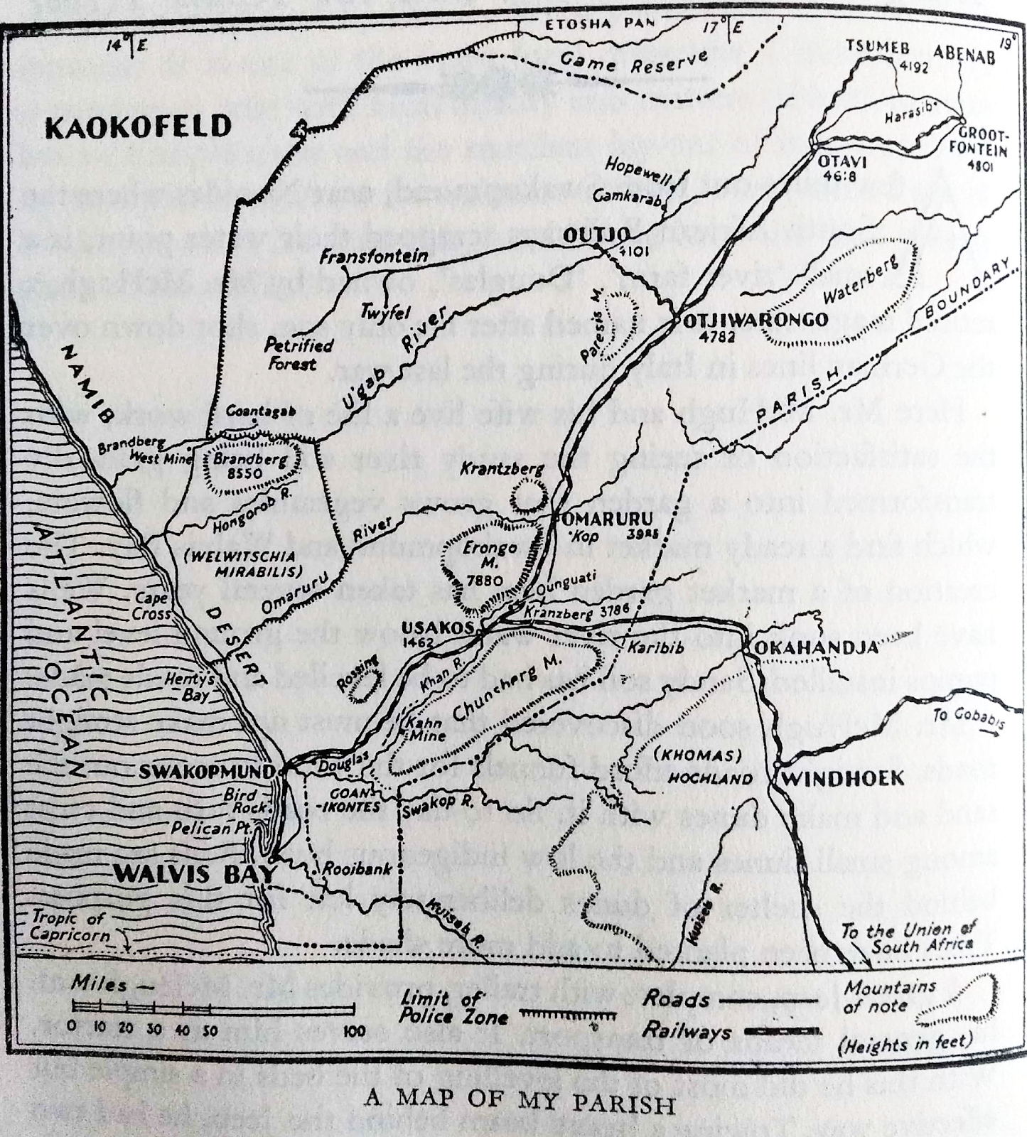
The parish of Anglican Rector Frank Haythornthwaite in 1950. Source: scan from Haythornthwaite 1956, p. 88.
A year of heavy rains but no flooding of the Kuiseb at Walvis Bay[659].
Owen-Smith notes that ‘[u]ntil 1950 the way of life in the Kaokoveld was primitive and little affected by the twentieth century – less than a generation ago white civilization was represented by a single European official stationed at Ohopoho’[660].
1950-1970
Game reserve no. 3, later enlarged as the Namib Naukluft park, is used as emergency grazing for white farmers[661].
Early 1950s
Köhler reports the regular migration of livestock to the Namib when surface water is available following good rain seasons, and the movement of whole communities to the forage resources of the Omaruru River following drought in the early 1950s[662].
1950s
Rejecting scientific concern regarding land degradation, the National Party continues to provide farms along the western escarpment and into the Namib desert[663]. ‘Pressure from white farmers’ causes the southern part of Etosha to be set aside for farmland[664], and ‘low-quality fencing’ starts to be erected ‘by white farmers along Etosha’s southern boundary’[665]. The west of the country is beset with widespread droughts and farmers often had to trek for grazing[666]. Wildlife are ‘increasingly considered an important part of Namibia’s tourism industry’[667].
Fuller writes for Sesfontein that ‘a second influx of outlying residents, again mostly Namidaman, occurred in the 1950s under the leadership of chief Simon IIHawaxab [son of a daughter of Jan |Uixamab]. These immigrations dramatically changed the ethnic and economic make-up of the community’[668]. [nb. Linked with westwards extension of ENP?]
A German Geographer H. Abel travels through Kaokoveld (1952, 1957) offering ‘a collection of about 40 photographs on different aspects of Kaokoland’s topography’, highlighting ‘tradition and social change in Namibia and southern Angola’[669]. He is pleasantly consoled by encountering ‘the self confident and proud but yet well behaved Ovahimba’ as an ‘ancient part of the Herero people [who should] be secured from contact with the white man’, in contrast to ‘the spoilt Herero of the farm zone’[670]. Bollig writes for the northern Kaokoveld ‘native reserves’/’chieftaincies that,
[s]ince the 1950s colonial officers openly acknowledged what they perceived as the local system of resource protection and sustained the power of the chiefs who had been nominated by their administration in all matters pertaining to land tenure.[671]
The last funerals take place at ǂArexas church and cemetary at !Aoǁaexas, prior to its proclamation as Daan Viljoen Game Reserve[672].
The permanent Ju|’hoan waterhole of G|am is used by ‘a handful of adventurous Herero and Botswanan farmers’[673].
Brahman cattle are introduced to Namibia and bred with other cattle breeds[674].
1950s-1960s
Khwe men from Caprivi are amongst those recruited to work as contract labourers in South Africa’s Witswatersrand gold mines, returning workers using their salaries to purchase cattle even though they were not permitted at that time in Caprivi[675].
1951
Publication of ‘Notes on the Kaokoveld (South West Africa and its People)’ by N.J. Warmelo, Government Ethnologist for the Dept. of Bantu Administration, Pretoria.
An expedition to Kaokoveld is financed by businessman Bernhard Carp who had ‘excellent relations with the South African and Southern Rhodesian academic establishments’, collecting thousands of different insects ‘including “over 100 new forms” and underlining ‘the exceptional status of the Kaokoveld as a repository of biodiversity’ as well as ‘the ‘otherness’ of the Kaokoveld’s fauna and people’[676]. Carp’s report mentions
a forager population at the mouth of the Hoanib River. He records them as comprising “3 bushmen, 2 bushwomen, 3 Damas and 3 Dama-women”, and continues: “They were called Sandloopers as they lived in the sand and also part of the year on the beaches of the coast, where they ate dead fish etc. Inland their diet consisted of grass veldkos and anything they could catch. They lived in scherms, no proper huts and had a very primitive life.[677]
This description thus clearly connects the people encountered on the coast with inland food resources.
Game Preservation Ordinance, no 11 is intended to improve Ordinance 19 of 1937 through providing,
more details about honorary game wardens and ma[king] provision for the appointment of game wardens in game reserves. Also of great practical effect was the authority given in this Ordinance to the Administrator to establish a Board to be known as the Game Preservation and Hunting Board, to consist of not less than five members. Their duty was to oversee the preservation of game and to make any necessary recommendations to the Administrator.[678]
The Ordinance also guides regulation of hunting on white farms, including restrictions on the amount of game that could be taken, the length of the hunting season, and penalties for infractions; although article 27 allows the administrator ‘to permit visiting dignitaries “to hunt any game in open season”[679]. It appears “that Africans were generally allowed to utilise wildlife resources in their communal areas” until restrictions were imposed by this Ordinance[680].
In this year at the start of a fisheries boom it is recorded that one fish processing factory (of six) in Walvis Bay ‘took one hundred and twenty thousand tons’ of fish[681]. Walvis Bay experiences a water crisis when the source at Rooibank ‘is said to be not yielding the water that it should or had previously done’, although also linked with considerable increase in consumption due to the growth of fish factories[682].
Haythornthwaite visits the ruins of Scheppman’s mission at Rooibank finding in ‘the thick dark green entangled growth of date palms, red and white oleander trees and other bushes’ concealed ruins, ‘the tumbledown ruin of the old wooden Mission Church, its palm-leaved roof fallen, and its front ready to topple in on top of it, and ‘traces of a garden’[683]. He notes that ‘[o]nce there was a large Hottentot settlement here. To-day no one lives near, except the 'boy' who looks after the water installation’[684].
Distributing Christmas gifts to children in the various ‘locations’ Haythornthwaite observes that this is ‘ financed chiefly from the profits of the Native Beer Hall in the Location, the profits of which must under law be given back by the Municipality in some way or other to the natives’[685].
Visiting settlements along the Kuiseb in the new year of this year for the Assistant District Surgeon’s (Dr Spiro) regular visit to take ‘them certain allowances and 'rations' and generally seeing to their well-being’, Haythornthwaite observes that,
[t]hey are a very mixed lot, Damaras, Namas, Hottentots, mixed Bushmen, all kinds, and they live a hard life. Tuberculosis of the spine is common among them, and all the venereal diseases. One wonders how they live out there in the desert. One wonders even more how the herds of goats that some have, manage to find sufficient food, even in the river bed. [62] We visited six settlements that day. Some had round huts. Some had square.[686]
And that,
There is one special plant that grows in the desert, the Naras. It is a strange-looking plant, rather like an untidy heap of tangled up, pale green barbed wire. On it grow small round fruit, a kind of melon. These the coloureds collect. They eat the soft pulp, making a kind of bread or biscuit from it. They dry the seeds. Some of these they roast, and they have a nutty flavour.
The dried naras seeds have a ready sale. Confectioners use them for flavouring and for ‘nut fillings’ and trimmings. Sacks of naras seed are brought into Walvis Bay, mostly on pack donkeys, and sold to the stores for cash to buy things like paraffin and the clothes [see 1953].
It is no light undertaking to trek to Walvis Bay from these settlements up the Kuiseb River with pack donkeys. It takes three or four days each way. All the water needed for the journey has to be taken along as well. There are donkeys all over the settlements as well as goats. Some of the donkeys have lived so long in the soft desert sand that their hooves have turned up in front like curved shoes.[687]
Further,
At one settlement Dr. Spiro asked for a girl by name. He was told she was not there. He asked where she was. Then they reluctantly said 'Sy is in die donker kamer' (she is in the dark room), and pointed to a small hut with closed doors and windows tightly shuttered.
Dr. Spiro knows these people well. He demanded that she be brought out, and no nonsense. She came out shyly, her two cheeks marked with bright red round spots of paint, She received her share of the good things of the party, and stole back to her room. It was her first menstruation. It is the custom for such a girl to be shut up in a dark room, all air and light excluded. You can imagine Dr. Spiro's 'stuff and nonsense' attitude towards that![688]
A sulphur eruption is recorded at the coast in this year involving the appearance of mud islands, lasting a few hours, inside Pelican Point[689].
At ‘Twyfelfontein’ / |Ui-ǁaes, a photograph is taken ‘at the remains of Elifas’s kraal’ – Elifas being the name of the Damara man and his family who were living there when the Levin family acquired the land in 1947[690].
The Marshall family (Dr Lorna Marshall withn husband Laurence, son John and daughter Elizabeth) first spend time in the Kalahari to research the livelihoods and lifeworlds of Bushmen[691], accompanied for the SWA administration by Claude McIntyre, an influential voice in the Commission for the Preservation of the Bushmen, chaired by Professor P.J. Schoeman, that recommended creation of a reserve both to preserve game and prevent Bushmen from bothering settler farmers, becoming the 17,540km2 named Bushmanland and focusing on Nyae Nyae[692].
1952
Oil prospecting starts in Angola and meets ‘with success’[693].
A SWAA colonial officer complains that Ovahimba Headman are unable to control their ‘subjects’, stating that:
[t]he Ovahimba Headmen serve no purpose whatsoever. They have no control over their subjects and in some instances appear to be afraid of them. Whenever a complaint is brought to them they seem unable to settle such but come to the officer for assistance.[694]
Vita Tom is considered more capable and ‘Europeanised’ in this aspect[695].
An Inspection report for the Kaokoveld by an Agricultural Officer recommends that the derelict gardens at Warmquelle, currently under small-scale agriculture by several families, be used,
to provide grazing and gardening ground for the Damaras who moved to Sesfontein from the Southern Kaokoveld. These Damaras, comprising 9 men, 12 women, and 22 children with 3 families still to come, are at present at Sessfontein and would seem to be virtually destitute. No huts had been built by them and their sole possessions are approximately 50 goats. It would seem imperative that some form of rationing be adopted until these people are Rehabilitated. At present they are living on “veldkos”.[696]
Farms in the Kaokoveld up to the Huab River are surveyed by a Mr Mendez, including at ‘Twyfelfontein’ (no. 534) surveyed at 12,223 has, [45] double what Levin had previously farmed[697]. The paintings and engravings at Twyfelfontein are proclaimed a Nasionale Besienswaardigheid (a National Heritage site) under Ordinance 13 of 1948 (but not a maintained as a tourist attraction), following surveys in the area by especially Dr Ernst Rudolf Schertz, and [57] Levin starts keeping a visitors’ book from this year[698]. Ostrich eggshell beads assumed to be ‘evidence of the San who used to live there’ are collected by the Levin children and ‘strung and sometimes sold to tourists’[699]. Over new year in this and the next year the Levins spend around a week in Swakopmund in tents rented from the municipality[700].
In his memoir Lords of the Last Frontier by popular author Lawrence Green, north-west Namibia and the Namib are portrayed as a frontier of civilisation and a ‘last frontier’, inhabited by ‘dying races’, for example:
of all the deserts I have seen it is the Namib that draws me again and again. This is a silent world, where men may well talk in whispers; and only in a few places will you discover human footprints on the sand.[701]
Such is Zessfontein, with its memories of old tragedies and its dying race. Sometimes in the moonlight the Hottentots[702] bring out their reed flutes and play the age-old music that Vasco da Gama and Simon van der Stel heard. Africa has nothing older in music than the reed flute. Each player blows upon a flute which gives one sound only; yet the flute orchestra produces a weird harmony as the musicians shuffle round in the sand. Only the old Hottentots possess this art, and only a handful of them survive. It cannot be long before they play their own requiem. Then the reed flutes will lie silent and forgotten in the sand as the full moon rises over the palms of Zessfontein oasis.[703]
Dieter Aschenborn, an artist, is appointed assistant game warden, stationed at Okaukeujo[704] (the first ranger is appointed in Etosha[705]). A bone-meal plant is built at Rietfontein, ‘the artisian spring between Okaukeujo and Halali’ to process zebra and wildebeest culled through the programme introduced by game warden Schoeman in 1951, before public outcry causes the culling to be stopped by the SWAA Executive Committee in the absence of records of numbers of animals killed[706]. Schoeman also starts to develop Etosha for tourism[707].
Policies are passed enacting conservation and control of the rich fishing grounds off Walvis Bay where ‘huge shoals of fish’ come right into the bay in October and November[708].
The Van Riebeeck Festival in Cape Town includes a prominent display of ‘live Bushmen’, while members of the Kwanyama Council of Headmen were brought to Cape Town to be present(ed) at the SWA pavilion[709].
1953
The ‘need for wildlife management practices to be based on scientific principles’ is recognised[710] and the first biologist, Bernabé JG de la Bat from the Cape, is appointed by Schoeman and stationed at Okaukeujo.[711] At this time,
the three existing Game Reserves, and legislation regarding game laws, were the responsibility of the General Branch of the Administration. This branch also handled many aspects which could not be attached to any other branch of the Administration.[712]
From a trip in 1953 Sesfontein is described as ‘approximately in the middle of the Kaokoveld’ and as ‘occupied by about 200 Topnaar Hottentots, who have continued growing the tobacco, mealies and other crops for their own comfort and sustenance’[713]. ‘Klipkaffirs’ from ‘across the Kunene … are reported to have mingled with the coastal sand-dwellers or Strandlopers’[714]. In May a Mr Louis Knobel from Pretoria in the company of Dr PJ Schoeman ‘the Game Warden of South West Africa’ encounter in the:
small Sesfontein community a small group of coastal Bush-Hottentot folk consisting of three males and an ancient doddering female, said to be their mother, who were reported by the Topnaar Hottentot elders, their overlords, to be the last remnants of what was once a large body of Strandlopers. It was the custom of the Hottentots to allow these Strandloper retainers to go down to the coast each year when the narra fruit was ripe. … On the coast this Strandloper group still subsists for several months on these fruit and the sea food found along the coast …, especially on the rocks about the mouth of such rivers as the Kumib and Hoarusib. This group, however, were not being allowed by the Hottentots to go to the coast for the past three or four years because of the bad seasons.[715]
Knobel’s photos form the basis of Dart’s 1955 paper. He tells Dart that ‘the boy who took them to the isolated huts where the Strandlopers were living informed them that his own father had been a Strandloper, but that his mother was a Topnaar Hottentot’; Schoeman on the other hand notes that ‘according to these Strandlopers’ own story, their stock had branched off froma a Name [sic] Hottentot tribe, somewhere near the Brandberg … in the Kaokoveld, but their predecessors had lived along the Skeleton Coast and up towards Rocky Point for hundreds of years’[716]. In this year Knobel and Schoeman met no living person along the coast between the Rocky Point and the mouth of the Kumib[717]. The three men photographed stand before a circular hut made of ‘pieces of wood, branches and palm fronds’ and are ‘clad in front and back aprons of buck-skin suspended from a girdle string’ ear-rings [176] and in one case a necklet of the type usually encountered amongst Bush peoples as well as rude sandals tied about their ankles with leather thongs’[718]. The paper proceeds with an objectifying account of the physical characteristics of the three men photographed. See summary and analysis in Sullivan 2021 and Sullivan and Ganuses in press.
A year of heavy rains but no flooding of the Kuiseb at Walvis Bay, although the Swakop comes down[719].
Haythornthwaite observes that ‘[n]early thirty tons of naras seed were exported from Walvis Bay in 1953’[720].
Guano from Bird Rock (see 1932) combined with the cheap labour of ‘boys’ yields Adulf Winter an annual income ‘running into four figures, sometimes five’[721].
Loans are available to settler farmers for purchasing breeding stock – for example, David Levin at Twyfelfontein borrows £500 from the Land Board which he had to pay off in 10 years[722]. David Levin treks with his family and livestock to Goedgevind near Sorris Sorris, belonging at the time to Gert Visser[723].
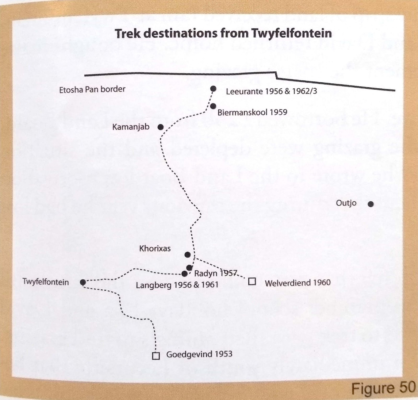
Trek destinations by the Levin family from Twyfelfontein. Source: scanned from Levin and Goldbeck 2013, p. 59.
1954
From this year a series of veterinary fences are erected in Botswana to control the spread of disease among cattle[724].
The administrative centre of Welwitschia [later renamed Khorixas] is established following announcement by administrator Mr JGH van der Walt and purchase of land from Mr Sias Koekemoer, [40] where farmers could sell pelts/wool through the Farmers Co-operative Union (FCU) and later Boere-Samwerk Beperk (BSB)[725]. Services were established for settlers in the area, including a bus from Outjo and telephone lines from Outjo and from Omaruru via Sorris Sorris, ending two farms east of Twyfelfontein (at Witwatersrand, no. 521, Piet Carstens)[726]. In April Twyfelfontein is offered to David Levin to buy for £736/5/0 (R1472.50) [727]. In May the Monuments Commission communicates with David Levin asking if he would like ‘to act as honorary supervisor of the rock engravings’ and [57] be furnished ‘with a visitors’ book to be signed by visitors’[728].
Archival research of files regarding farm records in the former ‘Damaraland’ indicates that Some farms are already established by 1954; others are established in 1954 and the years following[729]. Kambatuku reports that it is unclear how the then South West Africa Administration obtained farms, i.e. ‘whether they were virgin land [?] or confiscated from either Germans or the indigenous people’: ‘[s]ome of the farms in the Grootberg area were established on land previously inhabited by indigenous people, while others were established before the Union era’ [730]. A pers. comm. from former Inspector of Lands, H.J. Lombard, indicates that ‘the farms around Otjikondo were established German holdings, while most of the Ugab area might have been virgin land[??]. The Damara people were confined to the Erongo mountain range when the farms were being established’[731]: but this is an erroneous assumption as many sources document the presence of local people, esp. ǂNūkhoe, in the area of the Ugab, including the Okambahe Reserve.
State Settlement plan
In October 1954 (the year that Dept. of Lands records go back to) farms were advertised so that ‘landless white farmers’ could apply to an established Land Board, approved by the Administrator (‘the highest authority in Namibia back then’) for monthly grazing licenses on them[732]. These could be revoked at anytime, and applicants had to be a bona fide farmer, i.e. ‘making a living from farming only’ [echoed in later land reform bill[733]], and had to occupy a farm within six days of receiving approval[734]. The Inspector of Lands reviewed their progress after twelve months, following which the lease was extended or revoked[735]. Lessees were not supposed to allow anyone else to graze on the farms to which they had a license, but frequently they did assist each other with access to grazing and water - this was to reduce the likelihood of overgrazing through the lessee and sublessee having more livestock deemed appropriate for the estimated carry capacity; or to fell trees without permission from the district magistrate, in accordance with Proclamation 23 of 1925[736]. Normally many farms were applied for and the Administrator would allocate a specific farm to the applying farmer[737]. The first grazing licences were issued in Sept-Oct 1954[738].
In August, Palmwag 702 is advertised for landless white farmers to apply for a grazing license: nine farmers applied, and Johannes Marthinus Lock Carstens was successful – at that point he was sub-leasing Twyfelfontein at that point and had been moving around for a couple of years[739].
Of this process in the west in 1954 Sullivan writes,
[t]he region which later became the communal area of Damaraland was one of the last areas to be surveyed and settled due to its vulnerability to drought and its peripheral location regarding more established agricultural areas (Rohde, 1993: 29). According to recent archival work by Kambatuku (forthcoming[740]) it appears that the majority of surveyed farms in the north-west of Damaraland were not settled until 1954. Farms in the area were initially made available to white farmers through the issuing of monthly grazing licenses. Farmers would state their preference for a number of farms on their application and the Land Board would approve one of these to which the licensee had to move within six days of receiving notice of this approval. Qualifying licensees were required to be making a living from farming only, and their farming practices were regularly monitored as the basis on which they could retain their license (Kambatuku, forthcoming: 1). It is interesting to note that these restrictions are echoed almost to the smallest detail within the conditions laid down in the 1995 Commercial (Agricultural) Land Reform Act regarding eligibility for land holdings on acquired agricultural land…[741]
Damara are uprooted from the former Aukeigas (!AoǁAexas) Reserve and displaced to Okombahe/Otjimbingwe[742], causing enlargement of the Okombahe Reserve to 400,000has ‘through the addition of the farm Sorris-Sorris in order to accommodate the Damara inhabitants of the deproclaimed Aukeigas Reserve near Windhoek,due to the pending proclamation of this area as Daan Viljoen Game Park[743]. [**add more on these evictions – I think we can make something of the fact that they were taking place in parallel, in a similar way and with similar implications. Nb. The farm Sorris-Sorris where people were moved to in the north of the Okombahe Reserve was partly included (I believe) in the 1958 park boundary along the Ugab River**]
In the wake of the Commission for the Preservation of the Bushmen [1949], and connected with increasing tourism[744] and international conservation lobbying, from the beginning of this year the native commissioner of ‘Ovamboland’ convenes a series of meetings in Etosha to communicate to Haiǁom in Etosha ‘the decision [357] to expel them’, permitting only 12 families employed in the Reserve to remain[745]. These evictions of Haiǁom from what is then Game Reserve no. 2 are carried out by the then Native Commissioner of Ovamboland (Mr Eedes) under the direction of P.A. Schoeman, Chief Native Commissioner based in Windhoek[746].
The first mission in Kaokoveld is established at Oromana[747].
The Swakop River comes down and runs for a fortnight[748].
1955
Control over Native Affairs in Namibia is ‘moved from Windhoek to Verwoerd’s department in Pretoria’[749].
The Administration decides to establish a permanent section for “Game Preservation” with De la Bat [1953] its first chief (Chief Game Warden for South West Africa)[750]. Joubert writes that,
[t]he personnel, who until then were appointed on a 1 year contract basis, became incorporated in the Administration of SWA.[751]
At the establishment of this section (‘Game Preservation’), Game Reserves 1, 2 and 3 (establishment under German colonisation in 1907) were under its jurisdiction, with the present Etosha National Park [#2] undergoing several boundary changes “before being finalized by legislation in 1970”, whilst “the boundaries of the Namib Desert Park [#3] remained virtually the same since its proclamation in 1907”[752].
Regulations of Game Preservation Ordinance of 1951 are applied to African Reserves, thereby ‘cementing in law a de facto ban on hunting in these areas’[753].
The new veterinary boundary of 1955 (moved from its 1937 position) enables the addition of a large area of potential freehold commercial farmland to the west of Outjo (see maps below).
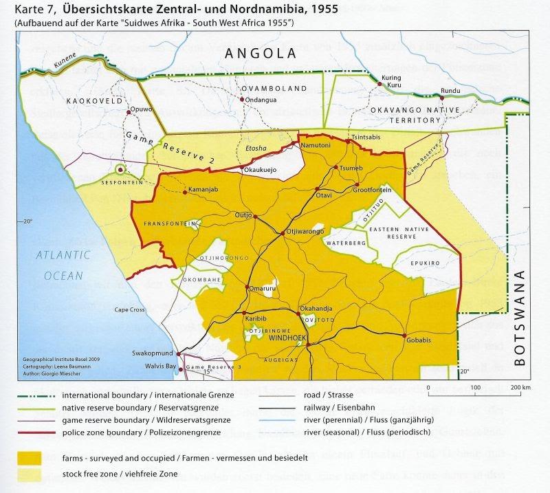
Source: Miescher 2009, p. 282f, shared by Ute Dieckmann.
San / Haiǁom are removed from Etosha[754]. Game ordinances only refer specifically to African Reserves from this year and preservation was the responsibility of the Dept. of Native Affairs but was ‘ineffectively implemented’[755]. The western portion of Game Reserve no. 1, east of Grootfontein, is converted into 30 farms[756], and surveyed farms expand greatly in Outjo District up to Palmwag in the west:
Expansion of surveyed farms in Outjo District. Source: scan from Schnegg and Pauli 2007, p. 13.
Sesfontein is described as ‘approximately in the middle of the Kaokoveld’ and as ‘occupied by about 200 Topnaar Hottentots, who have continued growing the tobacco, mealies and other crops for their own comfort and sustenance’[757]. ‘Klipkaffirs’ from ‘across the Kunene … are reported to have mingled with the coastal sand-dwellers or Strandlopers’[758].
SWA’s first Bushman Affairs Commissioner Claude McIntyre reports encountering women in Nyae Nyae left behind after ‘man-stealing’ for labour had removed their men-folk to settler farms[759].
1955-58
Damara are uprooted from the former Aukeigas (!AoǁAexas) Reserve and displaced to Sorris-Sorris[760]. [**nb. interview with Meda Xamses describes this experience, plus descriptions in LAC report].
1955-1965
SWA Administrator D.P. Viljoen introduces ‘a more formal approach to nature conservation’[761].
Late 1950s
Stoffel Rochér, ranger at Namutoni, sees ‘one of the last buffalo in Etosha killed by lions at Twee palms on the fringe of Fischer’s pan’ and around this time two buffalo are photographed at Andoni water point[762].
1956
Hungarian Revolution[763].
A dry year ‘for the whole of the Kaokoveld, extending all the way to Etosha Pan’ and meaning that farmers like the Levins from Twyfelfontein have to trek continuously, first to Langberg south of Khorixas[764]. On 1 June David Levin becomes title-holder of Twyfelfontein [see 1954][765]. There is not enough land for his neighbour Willie de Wit to the west (which becomes crown-land, i.e. belonging to the state), who drops stones into the borehole that had been drilled for him so that it is useless to anyone who wishes to graze west of Twyfelfontein[766].
In the context of this dry year, the evictees from Aukeigas / !Aoǁaexas are trekked to Sorris-Sorris – the farm added to the north of the Okombahe Reserve[767].
The National Monuments’ Council try again to get the original Cape Cross Padrão returned from Berlin to SWA, but is unsuccessful as in the eastern side of the city[768].
Anglican Rector Frank Haythornthwaite publishes his memoir All the Way to Abenab, recounting experiences and observations in his parish (see 1950). Based in Walvis Bay, he observes that,
Walvis Bay politically occupies a very curious position. Although to-day it is for all practical purposes part of South-West Africa, it really belongs to the Union of South Africa, and is officially part of the Cape Province, in fact it is part of the electoral division of Green Point, Cape Town, but when the Union of South Africa [23] accepted the Mandate of South-West Africa in 1920, it was agreed that Walvis Bay would be treated for administrative purposes as though it were part of South-West Africa. All laws and proclamations are given as applicable 'to the Mandated Territory of South-West Africa and the Port and Settlement of Walvis Bay.[769]
By this year the early 1950s Walvis Bay fisheries boom is already over[770]. He writes of finding the remains of shell middens and a ‘Hottentot settlement’ in the desert inland of Walvis Bay, where,
[i]f there had been huts, these had long since been swept away and obliterated by the wind that had made curious 'basins' in the eddies of the sun-baked mud. In these basins we found round ostrich-shell beads, a home-made blue glass bead, a few bone needles, a lot of broken pieces of black, rough cooking pots, crudely made and simply decorated.
A lot of fish bones lay around, including some very large vertebrae. There were literally hundreds of the small oval-shaped 'jewel' bones from the head of the despised barbel. Nearby, uncovered by the wind and sand-blasted, were the remains of several skeletons, but jackals and other animals had pulled them around. Small pieces of thin skull bone blew round in the ever-present wind, and thin paperish ribs flapped grotesquely.
I collected several pieces of broken pottery, some of the bone needles, all the beads I could see, and some of the jewel bones.[771]
He observes that the appearance of mud islands linked with suphur eruptions in 1904 and 1951 have been ‘likened ‘to similar eruptions in the West Indies where there is oil under the sea’ but that ‘[n]o one has thought of looking for oil in or around Walvis Bay’[772].
At the time of his office, the Omaruru River, 40miles north of Swakopmund, is the boundary of the ‘Police Zone’, beyond which a permit is needed for travel[773].
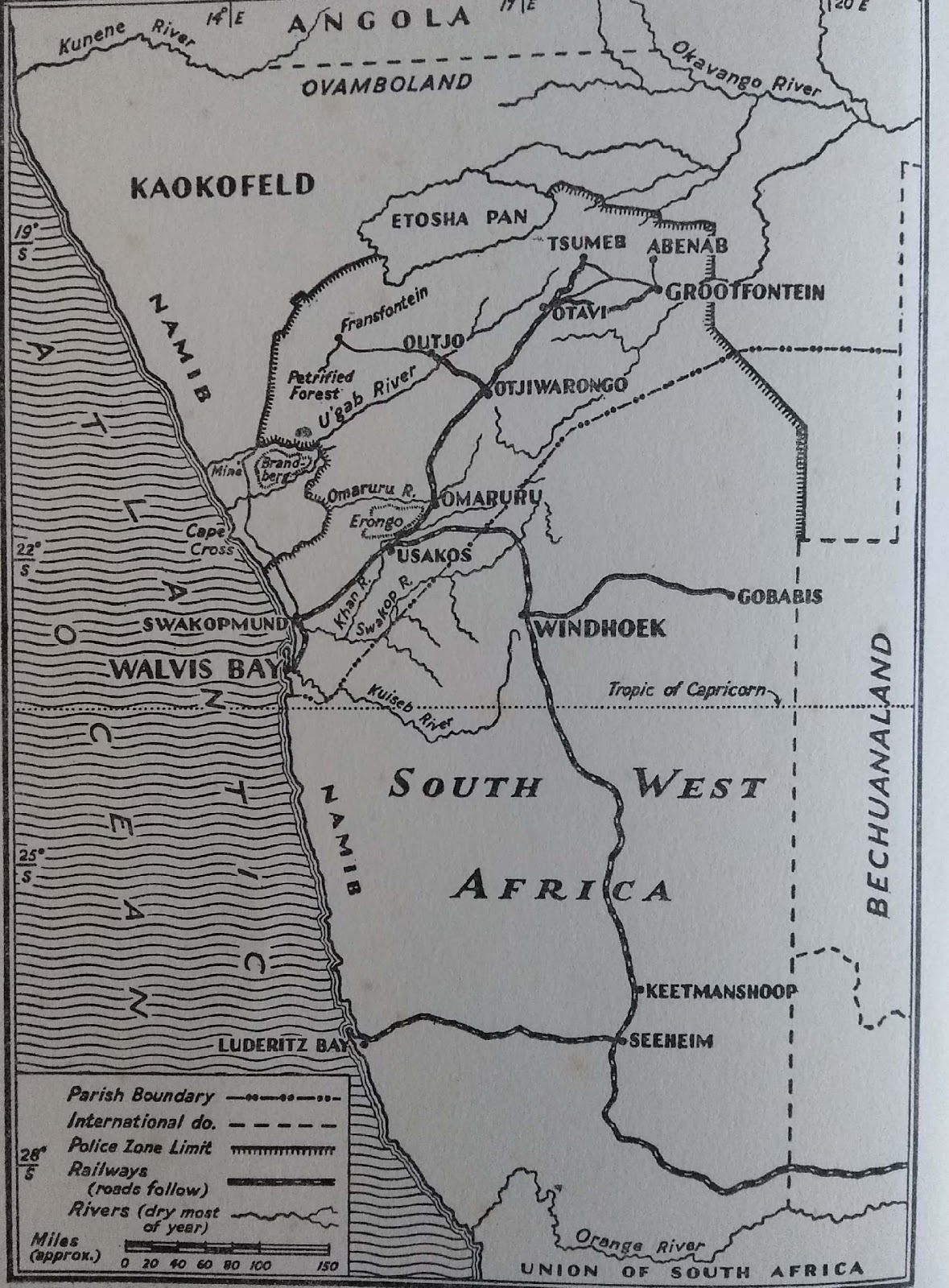
‘South West Africa’ in the early 1950s, focusing on the Anglican Parish of Walvis Bay and Northern Area and showing the boundary at the time of the Police Zone for which a permit was needed for travel. Source: scan from frontispiece of Haythornthwaite 1956.
The salt-producing area north of the Omaruru River and into the Police Zone was then ‘held by five companies who work closely together’, with the ‘actual labour … done by ‘boys’ who live in huts around the house of the white miner in charge’[774].
Tin and wolfram (i.e. wolframite, ‘an iron manganese tungstate mineral’[775]) are mined inland at Brandberg West and Albert’s Prospect (unclear where this is), and Haythornthwaite provides interesting (if at times ‘coloured’ by the racist mores of the day) detail of his trips inland to these areas which at the time were in the restricted area of the Police Zone:
[i]t is something of an adventure to visit this place as I occasionally do. Twice a week supply trucks go out from Swakopmund and return the following day, going out on Tuesdays and Fridays, returning Wednesdays and Saturdays. It suits me to go out on a Tuesday and return on a Saturday, which gives me three clear days at the mining carrp. The trucks take three hours to reach Cape Cross, the first ninety miles. They take five hours to do the remaining sixty-seven. There is a salt road to Cape Cross. There is no road beyond Cape Cross, just desert track.
Brandberg West Mine belongs to the South-West Africa Company [whose General Representative at the time was a Mr. Leslie Bristowe[776]]. Near Cape Cross this company also has some salt pans, so there is always a halt here, going and coming, and a warm welcome with a ready cup of tea from the miner in charge. On the way out the supply trucks off-load a few things, fresh water, fresh meat and other supplies for the miner and his 'boys'. On the return journey these trucks load salt and the halt is longer, [98] which I never mind after the lengthy, slow and not very comfortable journey over the desert.
The drivers of the fifteen-ton supply trucks are 'coloureds', that is mixed race, usually one of the 'native' races plus maybe a dash of white. Better drivers than these two who drive the trucks it would be hard to find. They have a care and a consideration for their trucks that is hard to find excelled by any driver. Every dip or pothole or rough patch of ground is carefully negotiated and no risks taken. It is arguable that this is plain common sense. Once the truck passes beyond Cape Cross, until it reaches the mine, there is no possibility of any assistance, should anything go wrong. Water is always carried in case of a breakdown, and there is always at least one other person on the truck. If the truck breaks down in the desert it is no use waiting for another to come along and give a lift into the nearest town. It is a case of 'Walk, brother. Walk', for anything up to thirty miles through barren, dry, wild country. No one lives in that area at all, not even bushmen.
It is a fascinating journey out to the mine. When the truck leaves behind the few houses at Cape Cross, it heads straight across the flat unending desert on which a track faintly shows. Faintly, because this is hard desert, with a surface of small, tightly packed stone chips, reddish and purple in colour. Away to the east are distant mountains. To the west is the sea, but the track veers more and more away from that. Ahead there is just vast space and emptiness. For miles it continues so in a brown tawniness of small hard stones. …
Long before the welwitschia plants are seen with any frequency, there has appeared faintly in the distance a majestic rounded mountain, looking rather like a couchant lion. It is a hundred miles away when first it is seen. This is the mighty Brandberg, eight thousand five hundred and fifty feet high, highest and most majestic and mysterious of all the mountains of South-West Africa. From the moment that it is first visible it dominates the landscape. Before you return to Swakopmund that mountain has asserted its personality upon you. It makes one realize something of what it was that made primitive people worship some mountains. Although we know nothing of it, I am sure that this [100] mountain has been worshipped. Around it, only less dominating than itself, are the many peaks that are called the Twelve Apostles, as such ranges tend to be called regardless of whether or not there are twelve peaks. As the road gets nearer to the mountains the great contortions of their stratification can be seen. There is something stupendous in thinking of the cataclysmic disturbances that produced it all.
The Hongorob River is like all South-West African rivers, a sandy bed devoid of surface water. The track crosses it at a point where the river bed is two or three hundred feet wide. To the west of this crossing there is to be seen a sudden deepened gorge and glimpses of queer-shaped weathered rocks. On the right, to the east as the track leaves the river bed, there is a huge welwitschia plant, the largest one to be seen on this trip. There is some grass growing in the faintly discernible rivulets and water-courses that feed into the Hongorob. Away in the distance there is a herd of zebra and their usual companions, the blaauwildebeeste. Occasionally there are a few ostriches, some eland, some springbok bounding away[777]. Meerkats run across the track and stand momentarily to watch what is coming before running into a hole. There are not many birds. Occasional sea birds fly inland and a few high-flying vultures look down on some dead or dying animal. There is no other life to be seen.
The light changes and with it the colouring of the landscape, from a bright, glistering, eye-straining, sun-bleached landscape it grows softer and warmer in colour, yellow, red and brown, and the distance turns from pale blue to deeper blue and purple. The track loses its dark hard flatness of small stones, and soon the road is down the dried and sandy bed of a river that runs eventually into the U'gab below the mine. There is struggling 'blinkhaar' grass, the aristides and the bushman grass growing in the river bed and a few acacia bushes. The descent goes deeper into the gorge, and the last glimpse of the Brandberg is of its flaming red and orange in the setting sun, and you see then one reason why it is called Brandberg, the burning or flaming mountain.
Suddenly round a bend in the river bed ahead there is a [101] cluster of roughly built huts. These belong to Berg Damaras or 'Klipkaffirs' as they are often called. They live here and some of them work at the mine. … They are remnants of early inhabitants of South-West Africa whom the Hereros hunted down and enslaved [a little simplistic..]. The Berg Damaras saved themselves from enslavement by taking refuge and hiding in the mountains (berg) and among the rocks (klip). Their huts are built of reeds and straw. They have a few goats. They too use the naras where they can find it. These particular Berg Damaras here have lived in the past on the proceeds of the alluvial tin they have won from the river beds. Now to-day this has been lost to them by the coming of the big companies to whom they hire their skill in handseparating the tin ore from the rubbish by 'scuttling', an action rather like a combination of winnowing and panning at the same time. They use long shallow wooden dishes, carved by themselves out of very soft indigenous wood [a ≠gôub]. Holding with both hands the dish filled with dry, finely crushed 'diggings', they perform a curious action rotating the dish on the right hand while at the same time they cant the powdered rock into the air with the left hand. The light dust blows away, and the 'pay-ore' collects at the right-hand end of the dish. The women are particularly good at this. As they can sell to illicit dealers the separated tin ore at more per pound than they can earn in a day's working for the white baas, it is not surprising that there is a leakage of ore when they are employed at scuttling, and a close watch and check has to be kept to prevent it.
Just below the huts another tributary river bed joins the descending one. The truck turns right and goes up it. Ahead, for it is usually quite dark by the time the truck gets there, are the lights of the Brandberg West Mine, scattered like fairy lights over an indiscernible landscape.
People loom out of the darkness as the truck pulls up under the lights outside the mine office. The truck's arrival means not only supplies for the mine. It means mail too. Most of the white men who work at the mine, about forty all told, drift in to see if there is any post for them.
[102] The mine manager's house is on top of a hill overlooking the mine valley. After arriving here at night, waking in the morning to see the valley in daylight for the first time is a fantastic experience. Brown rounded hills flank the valley with their twisted and exposed strata clearly to be seen. Over the tops of these hills faintly looms, now blue and now flaming, the rounded top of the Brandberg. Up the head of the valley there is clanking machinery, clanking stamps and rattling kokopans, and the machine-gun noise of the drills. Dotted about below are the houses, offices, stores and workshops of the mine. The white rectangular compound of the native workers stands a little apart. There are some goats straggling about in the valley and a few dogs.
In the freshness of the morning air, before the sun has begun to 'sting', is the best time to climb to the top of the hill behind the manager's house. It is worth the effort. There is a breathtaking vista of hills, hills, hills, rolling, rounded, brown, with little or no vegetation visible except for occasional patches that may be plants or lichen. Bare track-like paths cross and re-cross all over the sides of the steep hills and I do not know the cause of these. Far below is just visible the yellow sand of the river bed going down to join the U'gab. In every direction that one looks there are endless hills fading into the pale blue of the horizon. To the north are the high mountains of the Kaokofeld. To the south-east is the mighty Brandberg and its attendant Twelve Apostles.
Brandberg West Mine began as a mine for alluvial tin and wolfram, but the alluvial ore has been practically exhausted. Adits have been cut into the sides of the valley where the bedded ore has been found. It took some time to develop this, but the mine settled down to a steady output of ore as more and more machinery reached it after being brought that long journey from Swakopmund or, about the same distance, from Omaruru. The Berg Damaras are used less and less as scuttlers, except when the machinery breaks down temporarily and the output has to be maintained, or when new prospects are being tested. There is no water here. The nearest water is in the bed of the U'gab River four miles away, but that is too 'brak' for white [103] tastes, although the Africans drink it freely. Until recently all the drinking water for the white people had to be brought to the mine by truck. At first the water for the plant had to be carted up from the river bed by truck, too, until a four-mile-long pipeline was installed. Recently an ionization plant has been installed to render the brak water drinkable even for white people, and restrictions on drinking water are now a thing of the past, but this ionization is an expensive process.
Just as the Brandberg dominates the view and much of one’s thoughts, so too does the U' gab River 100m large in the life of the Brandberg West Mine. I was taken down to the river bed, late in the afternoon of the first full day I spent at the mine, by Con Steenkamp, then mine manager. We went in a Landrover, down the tributary river that does not seem to possess a name. The descent was down the firm sandy bed between sides of the river gorge that become deeper and deeper as one descends. There is soft bush growing in the river bed and some grass, but nothing grows on the rocky sides of the gorge. Here again one sees the fantastic twisting and contorting of the rock strata, great synclines, anticlines, monoclines, isoclines, and contorted combinations of them all. At one point the strata of the rock stands completely on its head, and goes straight up sheer for three or four hundred feet. At another point, where there has obviously been some downthrust and a fault, water washing through the broken rock has first washed out great natural squared pipes at the base of the cliff and then lined them, layer upon layer, with a lime deposit, till some have been completely filled in, in a square geometric pattern. Others are still open but eventually they too will probably be closed up. One of these openings was big enough for the dachshund we had with us to go right up it and disappear out of sight. Only the echoing sound of his hard little claws ringing on the stone gave sign of his still being there.
Down at the river bed where this tributary joins the U'gab there is 'open water', water actually standing in pools on the surface. Dense reeds ten to twelve feet high grow in the water. Among the reeds lurk lions and ticks, each in its own way waiting to prey on any luckless animals that come there to drink. I did [104] not see any lions, only some spoor, but I found when I returned to the mine that I had to take off all my clothes to 'delouse' myself of the ticks I had acquired. …
There are some gigantic anaboom trees growing in the river bed, testimony in their size to the rarity with which the river comes down in flood to-day. Even in the 1934 and 1950 floods they were not uprooted. A deep caisson[778], smaller version of those at Rooibank, has been sunk into the river bed. A pump draws the seeping water out of it and drives it up the pipeline to the mine. A 'boy' lives down in the river bed to look after the pumps. He keeps donkeys down there. The Africans love donkeys.
So do lions. This 'boy' lost three of his donkeys in one night from a lion whose spoor had been seen the afternoon before. …
[105] Occasionally a solitary rhino will go by, bound for open water up or down the river. Rhinos love trekking in this manner. I do not know of anyone who has actually seen rhino go by since the pumps have been put in, but spoor has been seen. With no reeds to rustle, a rhino would go quietly by.
In addition to the Brandberg West Mine, the South-West Company have other 'prospects' nearer the actual slopes and foothills of the Brandberg. One of these was one hundred and ten miles away by road. As this prospect, worked by one white man and thirty 'boys', had to be 'rationed' and watered from Brandberg West, this meant a weekly journey of two hundred and twenty miles, an expensive and difficult undertaking that took two days.
The Company's chief geologist, Dr. Brand, who has an intimate knowledge and great love of the Namib and the Kaokofeld, decided that this was much too far. After poring over his own maps of the area, very much more detailed and exact than the official, rather sketchy, survey maps, he set out one morning on foot, accompanied by two 'boys', from Brandberg West. He found a way through the mountains and marked it by placing beacons of stones as he went. He reached the prospect, known as 'Alberts' Prospect'[??] from the miner working there, after he had covered twenty-seven miles instead of one hundred and ten. Behind him, following his beacons, came gangs of 'boys' making a road. The road was completed in three weeks. Most of the road making consisted of clearing away loose stones and rocks, but in some places a great deal more than this, cutting down gradients and filling in holes, was required.
I have travelled this road to Alberts' Prospect. I could not help being filled with the greatest admiration for Dr. Brand's eye for country in spotting the route for the road. It is not exactly the [106] kind of road over which one would take an expensive limousine, but Landrovers and trucks with four-wheel drive go over it with no difficulty at all. When one says it is a fantastic journey, one means just that as so much of this country seems like belonging to a world of fantasy, lacking reality. At times it does not seem possible that there can be a road ahead through ridge after ridge of gaunt rocky mountains. But the road goes on.
The U'gab river bed provides a valuable level portion of the road and some breathtaking scenery. The descent into the river bed is fairly steep but never more than one in seven, and that only for short stretches. The climb out the other side is much the same. The river runs through a very deep gorge that has cliffs at least five hundred feet high. Green bushes, grass and flowering plants grow down in the river bed as well as an occasional tree.
One of the trees under whose shade we stopped for some food is near a mighty up rushing cliff of tormented strata. Bands of black basalt, white marble, green apatite, quartz, calcite and many other rocks sweep up almost perpendicularly, and the pattern is repeated on the other side of the gorge. It is awe-inspiring this sudden and violent intrusion of rock from some tectonic disturbance and upheaval perhaps a hundred million years ago or twice that time, although there are some who think this has all been very much more recent and that the whole of the U'gab river bed is the axis of a fault that is still on the move. All over one sees twisted upheavals. There is something almost pulsatingly alive among these tormented rocks. They have not the deadness that one would expect from such stark aridity of their barren sides. In their shapes and in their changing colours as the sun moves across the vast cloudless dome of sky, they seem personal. They are not unfriendly or repellent. They are exultant.
As the road climbs out of the river bed and reaches again the high plateau on the other side, occasional deep ravines run down through the rocks to the river bed once more, and there are glimpses through their red-brownness of the yellow sandy river bed. We stopped by one of these ravines. In the middle distance, rising sheerly a thousand feet, was a rockface that had, threequarters of the way up, a white square as if painted on with white-[107] wash. We saw more than one of these white squares high up on the rocks. They are caused by the 'dassie' or rock rabbit, the coney of the Bible. This, like the welwitschia plant, is a survival from a prehistoric age. The dassies are creatures of habit. These white squares mark the communal urinals of centuries of micturating dassies. The crystalline urine has given some idea of how long the dassies have been on this earth. It has been found in layers of rock that indicate the dassie has survived possibly over one hundred million years. On the wide plateau above the U'gab River roam much game, zebra, blaauwildebeeste, ostriches, eland, springbok as well as smaller game, duikers, stembok and the like. The wild turkey, the paauw or bustard abound as well as the omnipresent guineafowl.
All the time the majestic Brandberg presides over the whole landscape. It was quite early in the morning and the mountains still were in their matutinal[779] blue mistiness. But on the eastern shoulder of the Brandberg occasionally there could be seen the tinge of pink as some crag caught the sunlight. Later in the day, as we returned, the Brandberg was aflame with the sun lighting up all the bare red rocks, giving it even greater vividness and majesty than its remote blueness of the early morning and late afternoon and evening.
'Alberts' Prospect' is on a level piece of ground below the slopes of one of Brandberg's foothills. It is an alluvial tin and wolfram deposit. It is worked by a number of 'boys' with a few Berg Damara women doing the scuttling. There is a slight breeze blowing there most of the time, and the women make use of it in their scuttling. Working on a large spread-out canvas wagon cover they fill their scuttles with the crushed rock. They hold the scuttles high above their heads and carefully standing on the windward side, slowly pour the crushed rock to the ground, so allowing the wind to winnow away the useless dust. This they continue to do for some time, then proceed to scuttle in the more usual way.
The sight of these two women had a touch of the incongruous that I find always accompanies their wearing the Victorian cos-[108]tume of full skirts, high-waisted bodice, mutton-chop sleeves, fancy aprons and high head-dress, although theirs is not so high as the Herero women wear theirs. The two women I saw at Alberts' Prospect were each wearing dark blue flowered dresses. One had lemon trimmings and a lemon apron. The other had hers trimmed in red, with a frilly red apron. Their smartness was in great contrast with the men who wore torn and discarded 'European' clothes, often patched with all manner of unmatching cloth. [most of the male labourers seem to have been ‘Ovambo’]
[109] When Brandberg West was first opened, it was very remote, but to-day there is a radio link between it and the Company's headquarters at Grootfontein. Every morning at nine and again at four-fifteen in the afternoon, the mine manager goes on the air and reports to headquarters. A telephone would be costly to instal and difficult to maintain. There is an airstrip, too, to-day near the mine, and in three hours the distance between Grootfontein and Brandberg West can be bridged by air. By road it takes at least two days.
[110] It is remote country. It is not to be played with, but it can enwrap itself round one in all its moods. The mining community there find it so. Tempers sometimes get a little frayed through too much close proximity to one another day after day at work, but when the weekends come, one or more of the trucks takes those who wish down to the coast twenty-five miles away to the finest fishing in the world. Fresh fish is always welcomed by the camp. Competition among the fishermen runs high.
A German Professor called Dr. Lutz Heck visits Etosha ‘at least twice’ as a tourist and in an article published this year writes:
White and never-ending, the plain of the Etosha Pan lay in front of us. The paths of the game lay criss-cross over it, trodden by the hoofs of thousands of thirsty animals who since the beginning of time visit the watering places. Below us, at the foot of a steep ridge the water of a pool was reflected sparkling in the sunlight. It was midday and the zebra, wildebeest and a few gems buck lay peacefully by the water. It was like a picture of the Garden of Eden, and when we looked back on to the steppes the giraffe came into view among the Acacia trees.[780]
1957
Launch of the first space satellite, described by philosopher Hannah Arendt as an ‘event, second in importance to no other, not even to the splitting of the atom’[781].
400 ‘completely impoverished’ Anglo-Boers who had remained in Angola ‘were brought back to South Africa and South West Africa, but ‘[t]he black people who had accompanied the trekkers to Angola were not repatriated’[782]. Recently surveyed and established farms north-west of Khorixas are advertised[783].
David Levin at Twyfelfontein employs a Damara man called Stefaans to assist with looking after the farm, including building fences such as a 6.9 km fence along the eastern border of the farm, supported with a loan from the Land Board (rec’d May 1958)[784]. Levin is ‘called to serve as an elder’ of the Dutch Reformed Church (DRC), his ward stretching west of the Huab River north to Ohopoho / Opuwo[785].
A road to Tsumeb is built from Ondangwa, reducing use of the route Olukonda to Okaukeujo, west of Etosha Pan.
In May Köhler does field research with Topnaar and Bergdama along the Kuiseb River, writing that,
the population at the lower Kuiseb consists of Topnaar and Bergdama. This does not mean that both ethnic groups can be clearly identified as 'Topnaar' or 'Bergdama'. Intermarriage and influences from other ethnic groups have determined the image of the external appearance … [and] within the population at the lower Kuiseb due to long inter-ethnic relations, there is a sense of togetherness[786].
He visits 50 Topnaar and 14 Bergdama households with 153 and 43 individuals respectively, finding that many younger people are either at Walvis Bay or ǂGorob for work[787]. Field survey by Köhler indicates that although numbers of people along the Kuiseb were low, ‘the number of women did not exceed that of men’ (as in 1891 Walvis Bay census) although the phenomenon of a high incidence of 'relatives' and 'visitors' was observed, interpreted ‘closely related to the structure of the clan’ more broadly (i.e. is ‘found everywhere’) [788]. In years of poor pasture and low !nara harvest, the government provides rations to the needy[789]. Topnaar concentrations were at Rooibank and Swartbank and many were born there; some moved to the Kuiseb from Walvis Bay, Sesfontein and Bethany[790]. Of the Bergdama, some were ‘born at Kuiseb, especially in ǂNatab and Breuergu-!goab. Both places seem to be the most important centers from which members of the living generation spread’, others ‘came from places outside the Kuiseb valley, especially Otjimbingue, Okombahe and even the south of the country, and also Usakos and Walvis Bay. In some cases, the Bergdama claimed that their parents had fled the Otjimbingue Herero War and settled at the Kuiseb. The Kuisebtal was therefore sometimes an area that offered refuge in the tribal wars or in the clashes between the Germans and the Herero refugees’[791]. In 1957, Owambo contract workers were employed at Rooibank water installation which had (again) become an important centre; otherwise ‘[t]he population of the lower Kuiseb lives mainly from a. the harvest of the Nara-nut, b. the keeping of cattle and goats c. the manufacture and sale of charcoal and d. wage labor’[792]. By this year the place The place |Nomabeb, after the wild fig |nomas, has become known by the Namib Desert Research Station under the name 'Gobabeb'[793].
The church emerging from the work of the Rhenish Mission becomes independent[794].
1958
Ordinance 18 of 1958 (signed off by Daniel Thomas du Plessis Viljoen, Administrator of South West Africa) replaces the ‘Hunting Board’ [1951] with the ‘Parks Board’ which has similar functions but includes ‘civil servants from agriculture, police, native affairs, the chief game warden and members of the farmers’ and hunting associations’, and gives the Administrator ‘the power to declare any area a game park’, to amend park boundaries and to provide for ‘the establishment and proclamation of private game reserves’[795]. The Board,
became more specialized, and consisted of the chairman who was the member of the Executive Committee charged with Game Preservation, the Director of Agriculture, the Deputy Commissioner of Police, the Chief Native Commissioner, a member of the SWA Farmers’ Association, a member of the Hunters’ Association and in an advisory capacity the then Chief Game Warden and at present [1974] the Director of Nature Conservation and Tourism.[796]
The Ordinance was also notable in that it enabled farmers to have their property proclaimed private game reserves with the same legal protection as a game park[797]. The granting of hunting permits during the non-hunting season is permitted for foreign visitors[798].
This Ordinance (18 of 1958), also provides for the creation and definition of ‘Etosha Game Park’,[799] with Game Reserve no. 2 under section 3(2) of the 1928 Prohibited Areas Proclamation (no. 26) repealed and substituted with ‘the area bounded as follows’:
From a point where the common border between the Territory of SOUTH WEST AFRICA and PORTUGUESE ANGOLA meets the coast of the ATLANTIC OCEAN, proceeding generally eastwards along the aforesaid common border to a point where it is intersected by the meridian of Longitude 14° East, then south-eastwards and eastwards along the boundary of the Magisterial District of Ovamboland to a point due North of the north-western corner beacon of the farm Onguma. 314, then generally southwards along the boundaries of but excluding the following farms in succession, in the Magisterial District of Tsumeb, viz. [2] Onguma 314, Vergenoeg 942, Kleinbegin 941, Leeudrink 940, farm 658, Heliodor 857, Obab 856, Mara 840, Mopanie 447, Lynplaas 436, Vrede 435, Olifantslaagte 433, Nooitgedag 418, Hestria 417, to the north-western corner beacon of the last mentioned farm, then generally westwards along the boundaries of but excluding the following farms in succession in the Magisterial District of Outjo namely Renex 494, Grensplaas 473, Tsabis 47O, Werda 469, Nuchas 468, Elandsfontein 463, Mooiplaas 462, Koppies 457, Oberland 455, Montebello 456, Leeupoort 441, Margo 436, farm 436, Sonop 434, farm, 432, Avondrede 430, Eindpaal 429, to the most northern beacon of the last mentioned farm, then generally westwards and southwards along the “Police Zone” boundary up to the mouth of the UGAB RIVER [=dictated by the police zone boundary which marked the limit of surveyed farms] then generally north-westwards along the Atlantic Coast line to the south-western corner of the Kaokoveld Native Reserve, then generally north-eastwards along the boundaries of but excluding the Kaokoveld Native Reserve, Sesfontein Reserve 207, Kaokoveld Native Reserve up to a point where a straight line from one kilometer south of the waterhole Otjokaware (Kowares) extended westwards to the waterhole Cerehamis (situated on the Gomatum River, a tributary of the Hoarusib River) intersects the south-eastern boundary of the Kaokoveld Native Reserve, then westwards in a straight line to the waterhole Cerehamis, on the Gomatum River, then westwards along the Gomatum River to its junction with the Hoarusib River, then south-westwards along the Hoarusib River to its mouth on the Atlantic Ocean, then northwards along the coastline of the Atlantic Ocean to a point where the common border between the Territory of SOUTH WEST AFRICA and PORTUGUESE ANGOLA meets the coastline of the Atlantic Ocean being the point of beginning.[800]
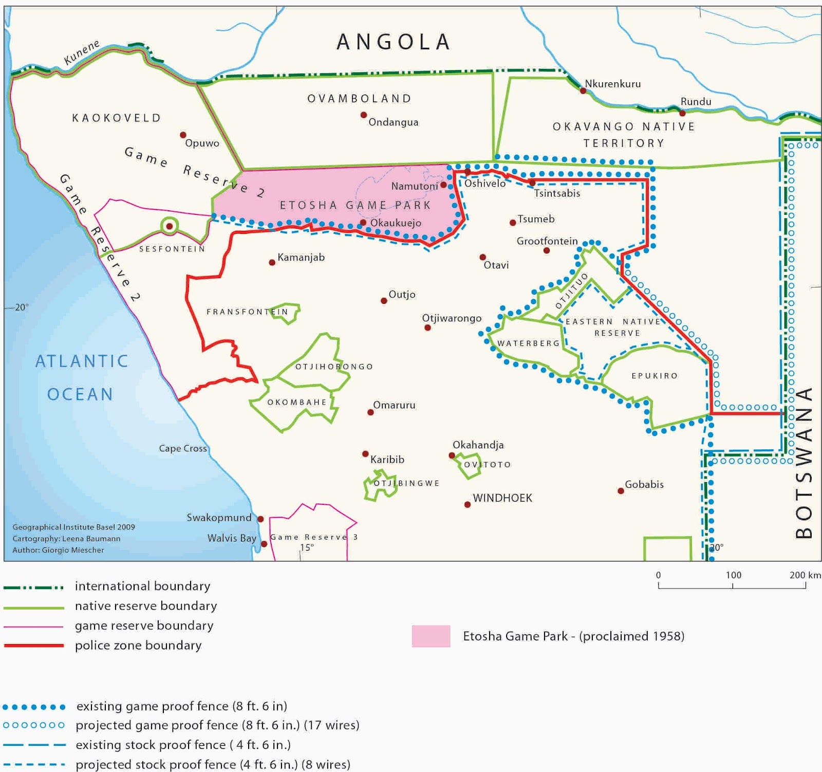
Boundaries in 1965, showing the extent of Game Reserve no. 2 (as per Ordinance 18, 1958), the Police Zone boundary, and existing and projected game and livestock fences. Source: scan from Miescher 2012: 170, colour version received from the author and included with permission.
The south-westwards extension of Game Reserve no. 2 thus stretches for 250 km south of the Hoanib River to the Ugab (!Uǂgāb) River[801] (cf. oral history that, ‘[t]hey are only giving us the place from !Nao-dâis to the other side, and they don’t want us to move in this area. They said this is now the wildlife area and you cannot move in here. They had to move to the other side - to Tsabididi’[802]). The area around Etosha Pan is renamed Etosha Game Park and from 1 June visitors are able to obtain permits to visit Etosha from officers at Namutoni and Okaukeujo, rather than through the Magistrates Office which is seen as increasingly impractical[803]. For map of these boundaries, see 1965.
The westwards extension of Etosha adjuts farms upto the police zone boundary which from this year were awarded on a one year probation lease to farmers who had been occupying them, provided they were bona fide farmers and regular inspections indicated that they had ‘brought about sufficient improvements’ – and supported by significant subsidies, loans, advances and drought relief on the basis of Inspection Reports by the Inspector of Lands[804]. Mostly karakul sheep and goats were herded by these settler farmers with cattle limited by aridity[805]. Estimated farm ’carrying capacities’ frequently differ from report to report for the same farm, reflected dynamic environmental conditions[806]. Sullivan summarises the situation as follows:
[p]robationary leases were made available to farmers in the newly surveyed farms of south-east Damaraland in 1958 following the advertisement of these farms in 1957. The eligibility of applicants from among the existing grazing licensees was based on whether appropriate infrastructural improvements had been made to the farm, and again farmers had to prove that farming was their primary source of income . Leases were granted initially for a one-year probationary period[807].
Regarding the Namib Game Reserve, in this year,
the eastern boundary was moved inland and the northern boundary northwards to include land to the north of an additional 5 120 km2.[808]
At Twyfelfontein north of the Ugab River there were no fences or enclosures until this year, when fences were used to raise lambing rates through controlling breeding by separating rams from ewes[809].
Late 1950s
Stoffel Rochér, ranger at Namutoni (ENP), sees ‘one of the last buffalo in Etosha killed by lions at Twee palms on the fringe of Fischer’s pan’ and around this time two buffalo are photographed at Andoni water point[810].
In Kaokoveld, 43 boreholes are drilled around Opuwo or or south-east of Opuwo[811].
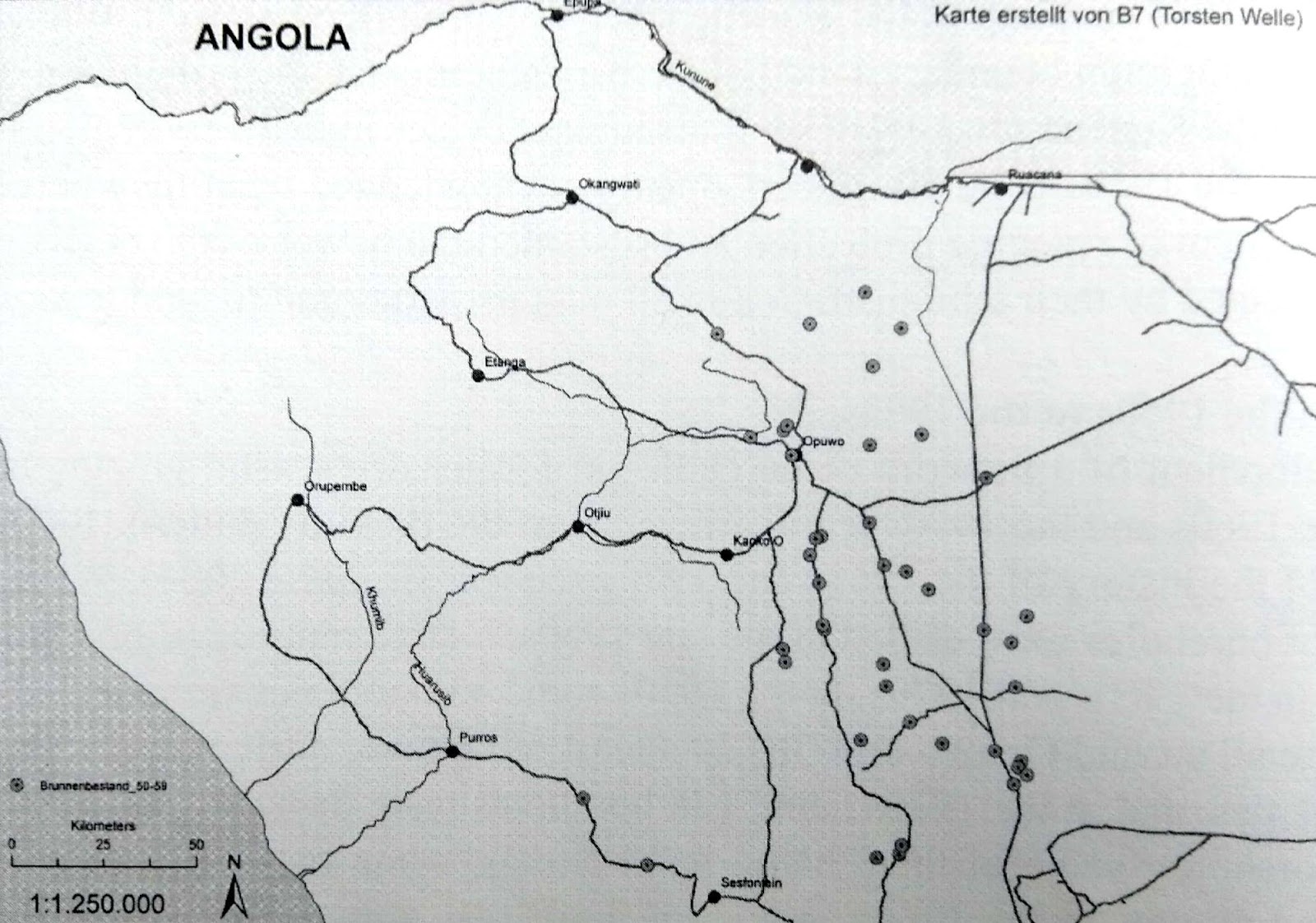
Boreholes in Kaokoveld in late 1950s. Source: scan from Bollig 2006, p. 44.
Late 1950s-early 1960s
‘An estimated 25,000 plains zebra and 25,000-30,000 wildebeest made an annual anti-clockwise migration along the western side of the Etosha pan, with some wildebeest moving in and out of Ovamboland in the north’[812]. … ‘During the 1950s and early 1960s, Etosha staff had begun an intensive borehole drilling programme in the woodlands west of the Etosha pan’; ‘Etosha’s herbivores exploited grazing areas where water was not previously available’[813].
1958-1972
In these years, 132 farms, with an area of 1,021,902 ha, are proclaimed as game parks under Ordinance 18 of 1958.[814]
1959
On 1st January, probation leases to farms north-west of Khorixas are extended to five years,
after which the farmers had the option of either buying or extending their lease for a further five years. These leases normally attached conditions for farm improvement, but this was usually implemented with very generous State loans and advances[815].
Drought conditions in this year ‘initiated financial relief amounting to exemption from paying interest or rent during a period from April 1959 to March 1961’[816]. Loans acquired for purchase of cattle were not required to be repaid and these stock simply became their property [effecting preferential primitive accumulation of land, ‘improvements’ and stock][817]:
Despite the considerable State benefits that farmers had access to when settling in these areas, however, it should not be forgotten that they were attempting to establish farming activities in an extremely remote area characterised by wide mountainous vistas and rocky terrain. As the first licensee of Kliprivier Farm describes, having experienced elephant damage to his installations and with numerous sheep with legs broken from the terrain, 'after having gone through all the trouble of constructing seven miles of road, a well, dam, trough and a dip tank, I cannot see a way of making a living out of the farm'.[818]
Some farmers allegedly used the subsidised settling of the Damaraland farms as a profit-making exercise through land speculation.[819]
Resistance to the forced removal of the ‘Old Location’ / ǂKhari-!As (Klein Windhoek) in Windhoek leads to 11 people being shot dead[820]; reported in The Namibian as ‘the Old Location massacre on 10 December 1959 when the apartheid police shot 13 to death and injured more than 38 protesters. The people were against being moved to Katutura to make way for Pionierspark and Hochland Park – whites-only suburbs’[821]. Damara Chief Fritz |Hobahe [|Howae] Gariseb (a deputy of Gaob Dawid Goreseb) plays a major role in the resistance by taking a stance against the removals[822], having already been beaten by Security Forces on the 4th December for refusing to provide the value of his house[823]. A student uprising associated with the Augustineum Training College in Okahandja also unfolds[824].
On On Christmas Eve, Claude McIntyre arrives in Nyae Nyae as SWA’s first Bushman Affairs Commissioner charged with establishing an administrative centre which he does in Tsumkwe / Tjum!ui[825].
1959-1962
Drought[826].
1960
SWAPO is founded and begins to fight a guerilla war from southern Angola[827], with Angola at this time having an estimated five million people, having had ‘an estimated three to five millions slaves’ exorted, ‘of which Portuguese, many illiterate, and Germans formed a very small minority among the various African tribes’[828]. Liberia and Ethiopia apply to the International Court of Justice (The Hague) ‘for a binding judgement against South African occupation’ of South West Africa, increasing international attention on the region[829]. Uprisings against the Portuguese in Angola stimulate the South African government to spend,
a great deal of money on constructing macadamized roads in South-West Africa, from the Orange River in the south to the banks of the Kunene in the north, from the Kalahari in the east to the Atlantic Coast in the west. The government also built airports and expanded the harbor in Walvis Bay. All this was done with a view of being able to move troops rapidly northward to keep any possible conflict outside its own borders, hopefully also outside its buffering mandate[830].
The Land Board is restructured[831].
In February, following a few years’ correspondence, David Levin of Twyfelfontein purchases Farm No. 741 Twyfelfontein Annex for 6d (5c) / ha (3799 has), on a basis of 8 has / small stock unit (revised upwards from 4 has / SSU).
A population census of ‘Kaokoland’ records 9,234 people and these figures inform the Odendaal report [see 1964][832].
1960s
The veterinary cordon fence - ‘Red Line’ – is erected[833], merging the previously established settlement and veterinary borders[834]. A campaign in Kaokoveld reduces the number of predators[835] and 136 boreholes are drilled here[836].
The glossonym ‘Nama’ is officially changed to ‘Nama/Damara’ or ‘Damara/Nama’ in recognition that ‘it does not cater for the Damara majority that speaks the language’[837].
1961
New legislation in 1961 [Angola?] virtually eliminated the worst abuses of labour[838].
Some farmers in Welwitschia administrative area have given up farming because of drought conditions – for example, Boy Blaauw (Andries Blaauw’s son?) from Langberg south of Welwitschia is working as a Foot-and-Mouth inspector and Betta Blaauw is managing their restaurant, Boererus Kafee / Farmers’ Rest Café[839].
Ecologist R.C. Bilgalke provides ‘an in-depth analysis’ of how plains zebra and wildebeest herds in Etosha ‘alternated between dry and west season grazing areas, following localised rains en masse’[840]. A Nature Conservation annual report notes that farmers are permitted to kill six species as ‘vermin’ on their land: jackal, hyena, wild cats, leopards, wild dogs and lynx[841]. Rietfontein in the Omaheke, at this time occupied by independently foraging Ju|’hoansi, is ‘formally ceded by the colonial administration to the Herero king’ as an extension to Hereroland East, leaving southern Ju|’hoans without any legal rights to land here[842]. By this year !Xo and Nharo-speaking communities in the southern Omaheke have been ‘forced to surrender the last of their lands to white farmers and Herero’[843].
33 artefacts donated by Hoernlé to Radcliffe-Brown are transferred to the South African Museum, ‘later used in the reconstructed Nama diorama which has featured in the African Cultures Gallery for some decades’[844].
The DRC of SWA founds a missionary station for the Bushmen/San in Tsumkwe, supported by the Welwitschia (Khorixas) congregation and visited once a year by David Levin from |Ui-ǁaes / Twyfelfontein (reknowned for its ‘Bushmen’ engravings) to established needs and prepare reports / recommendations for the church council in Welwitschia[845].
1961-63
Outbreak of foot-and-mouth disease leads to separation of the combined settlement and veterinary border (the ‘Red Line’)[846], and Game Reserve No. 1 is deproclaimed in favour of farming[847], and game-proof fencing is erected along Etosha’s southern boundary[848] – 290kms in length, ‘from the farm Renex to Otjovasundu’, nonetheless repeatedly damaged by elephants that then caused problems to neighbouring farmers and sometimes had to be shot[849].
1962
Re: the south-westwards extension of Game Reserve No. 2 along the Ugab River (cf. Ordinance 18 of 1958), Joubert writes:“[t]his area was exchanged in 1962 for Game Reserve No. I which was deproclaimed as game reserve and became part of the Kavango Homeland” – i.e. it seems that there was a lag from Ordinance 18 etc. and any reality of the westwards extension[850].
The South African government sets up a Commission under Frans Hendrik (Fox) Odendaal – administrator of the Transvaal in RSA[851] – ‘to propose means whereby the indigenous people could “develop” more rapidly’[852] and ‘to enquire into “further promoting the material and moral welfare, and social progress of the inhabitants of South West Africa, more particularly its non-white inhabitants’[853], following Dr. F.R. Tomlinson’s ‘homeland’ recommendations in South Africa[854], i.e. to realise ‘the policy of separate political development of ethnic groups in South West Africa’[855]. The Commission’s terms of reference were ‘to enquire thoroughly into further promoting the material and moral welfare of the inhabitants of South West Africa, and more particularly its non-white inhabitants... while taking fully into consideration the background, traditions and habits of the Native inhabitants’[856]. The primary objective of the Commission was thus to identify the so-called ‘land requirements’ of the ‘groups’ as defined and racialised in the report, and delineate an appropriate area of land for each group in the light of these investigations[857].
Africans testifying to the Odendaal Commission ‘condemned the government’s failure to keep promises’, such as refusal to access natural resources in Mahango and Khaudum game parks despite promised continued access[858]. It was unknown to settler farmers in the Kaokoveld that part of the Commission’s remit was to consider establishing a ‘homeland’ here for Damara people[859].
Reardon later describes this moment in the following terms:
In 1962 the South African government, in line with its policy of creating independent black homelands, established a Commission of Enquiry into South West Africa, referred to as the Odendaal Commission after its chairman. It included among its recommendations the deproclamation of the 55,000 square kilometre Kaokoveld game conservation area except for a 32 kilometre-wide strip down the Skeleton Coast and the ceding of more than half of the Etosha Game Reserve to the proposed Kaokoland, Damara and Ovambo homelands.[860]
Heydinger later writes that ‘[i]n Etosha-Kaokoveld, Odendaal sought to sever a previously unified landscape, historically shared by semi-nomadic pastoralists and wildlife’[861]. This is a somewhat puzzling statement, however, in view of the dramatic previous administrative reorganisations of pastoralist-hunter-harvesting peoples in the north-west. These were effected, for example, through Ordinance 18 of 1958 that stretched Game Reserve no. 2 across the west from the Hoanib to the Ugab rivers, as well as through previous evictions relating to a repositioning of the Police Zone boundary to permit expansion of the north-west commercial settler farming area, and iterative and incomplete attempts to clear the area beyond the Police Zone as a livestock-free zone[862]. There are reportedly 3,000 elephant in Kaokoveld in this year[863].
Re-issue of ‘Notes on the Kaokoveld (South West Africa and its People)’ by N.J. Warmelo, Government Ethnologist for the Dept. of Bantu Administration, Pretoria.
On 10 May, a United Nations Special Committee for South West Africa mission to the country holds a meeting ‘with Headmen and residents of Sessfontein Native Reserve’ in which the loss of land and grazing due to European farming after the 1955 expansion of the Police Zone was high on the agenda of residents’ concerns. The report from this meeting states:
[a]t this Native Reserve, the Chairman and Vice-Chairman met Mr. Simon Hawahab, Headman of the Topnear Nama residents, who numbered only 36 to 4O persons, Mr Elias Amgab, Headman of the Damaras, about 20O to 30O of whom lived in the Reserve, and Herero Headman Urimunge Kasaona … By the end of the meeting some one hundred or more residents of the Reserve had gathered. Their common complaints related to the encroachment of Europeans on their grazing lands, their freedom of movement, and the low wages paid by European employers, [plus inadequate schooling in the Reserve].
They stated that the people of Sessfontein used to be able to graze their livestock south of the Hoanib River. However, European farmers had taken the land all the way to the boundary of the Hoanib river, and were occupying most or the grazing veld which had been formerly used by the people of Sessfontein. Moreover, the farmers did not want the people of Sessfontein to travel through the land now occupied by the Europeans. As a result, to reach the nearest store, at Kamanjab, the people of Sessfontein had to travel over a new road a distance of 135 miles, whereas the road they had been in the habit of using, and which they had themselves built during the period of German administration, was only some 60 miles long. Furthermore on the short route they could obtain water; on the longer one they could not. They therefore wanted the Europeans to move further away so that the residents of Sessfontein could regain their grazing lands and they wanted again to be allowed to use the short route to Kamanjab. They also wanted to be provided with tractors and plows in order to be better able to plant and grow their seeds.
When these complaints were brought to the attention of the Chief Native Commissioner, he observed that the net and longer route had to be used owing to cattle disease control measures and that in any case, the old rold was in poor [14] condition. He stated that the complaints would, however, be investigated. Subsequently, the complaints were also brought to the attention of the Deputy Minister for South West African Affairs, who stated that there were no European farms in the area, which was outside the Police Zone, but who acknowledged that Europeans might nevertheless be allowed to use that land for the purpose of grazing their cattle.[864] [tbc]
The Secretary for SWA points out that ‘no game had yet been identified as a carrier of the disease [foot and mouth] and that large numbers of kudu had been decimated by drought, more so than any organised extermination campaign could have accomplished’, in response to concerns regarding possibility of game being foot-and-mouth carriers[865]. De la Bat estimates 100,000 large herbivores in Etosha[866].
Cymot and Striped Giraffe Shelters in southern Erongo Mountains are excavated during the course a South West African Scientific Society expedition[867].
This year sees a peak of 16 in the concentration of ‘Bushmen guards’ in Kavango [see 1947][868].
1960s
Etosha’s numbers of large herbivores begin falling[869].
1963
The Game Preservation Section is upgraded to the Division Nature Conservation and Tourism under the directorship of Mr B.J.G. de la Bat[870] who moves from Okaukuejo to Windhoek as the first Director of the Division and a full-fledged nature conservation research institution (at Okaukeujo?) is established[871].
In this year reportedly ‘a mysterious consortium from Pretoria start[s] to buy up farms near Welwitschia [Khorixas]’ … ‘offering prices according to farm size and improvements’ of around R3-4/ha, and late in this year rumours begin ‘to circulate that the South West Africa Administration intended to buy all the farms in the Kaokoveld in order to create a homeland for the Damara people’[872]. The Odendaal Commission report is presented to the Administration in December and all the farms ‘in what was then known as the Kaokoveld were included into the area that was to be renamed Damaraland’[873]. Many farmers did not want to sell and the farmers’ unions (boereverengigings) tried to protest[874].
OvaHerero associated with Headman Kephas Muzuma appear to have been moving livestock across the unclear ‘Kaokoveld’ / Etosha boundary, Muzuma stating in this year to the administration that:
[o]ur income derives only from livestock. But if we take our animals across the cordon they will be shot. It is dry. What do we do now? We are hungry and our animals are dying.[875]
The Odendaal Commission’s recommendations are submitted to Verwoerd in June. ‘unambiguously plac[ing] apartheid policies at the centre of governing Namibia … setting aside 48.26 per cent of the colony for whites in the Police Zone, whilst the remaining 51.74 per cent went to “homelands”, towns, game reserves, diamond areas, government lands, and the municipality of Walvis Bay, the country’s only deep-water port, which remained part of South Africa’[876]. Existing (1963) Native Reserves and communal areas are shown in the Odendaal Report in the map below, which omits the 1958 boundaries of Game Reserve no. 2 (see 1958 and 1965) [[?**this map seems to depart from the area designated as Game Reserve no. 2 in Ordinance 18 of 1958]:
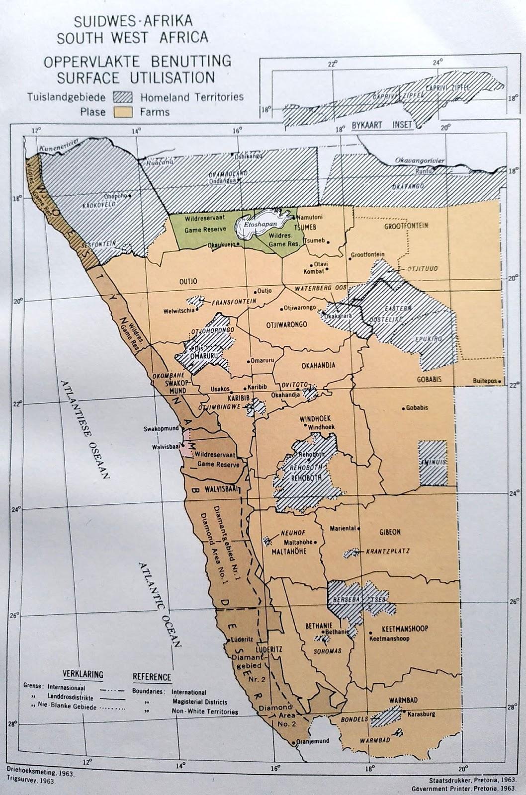
Existing ‘Native Reserves’ and communal areas (lined) in 1963: scan from Odendaal Report 1964, Figure 9.
The !Khuiseb floodwaters reach the ocean[877].
A leopard is seen at Twyfelfontein / |Ui-ǁaes[878].
The RMS establishes a private Sekondêre School for black students in Karibib[879].
The Namib Desert Research Station with links to the Transvaal Museum is established at Gobabeb[880].
West Caprivi is declared a ‘Nature Park’, despite recommendations from the Odendaal Commission, ‘a key apartheid land planning body’ that it should be ‘converted into a “homeland” for Bushmen’[881].
1962/3-early 1970s
In these years following establishment of the Division of Nature Conservation and Tourism, and despite rising land prices due to the purchase of farmland following the Odendaal Commission resulting in “a large number of farmers looking for other farms to settle”, 10 “nature conservation areas” were proclaimed at a rate of almost one a year, the aim being to represent all major habitats in the territory.[882]
[1] Rudner and Rudner 1974[1899], f35 p. 179.
[2] Rudner and Rudner 1974[1899], f36 p. 179.
[3] Kanzler 2012(2003), p. 44.
[4] Bridgeford and Bridgeford 2002, p. 31.
[5] Kanzler 2012(2003), p. 45; http://rehobothbasters.org/cases/244-sam-khubis accessed 081218.
[6] !Haoës 2010.
[7] !Haoës 2010.
[8] Kanzler 2012(2003), pp. 44-45.
[9] Silvester and Gewald 2004, p. xvi.
[10] Bruwer 2006(1985), pp. 5, 7.
[11] Silvester et al. 1998, p. 14; Silvester et al. 1998, p. 7.**
[12] Sullivan 1996, p. 14.
[13] Bruwer 2006[1985], p. 32.
[14] Bruwer 2006[1985], p. 31.
[15] Bruwer 2006[1985], p. 6; Kanzler 2012[2003], p. 45, 54
[16] Bruwer 2006[1985], p. 6.
[17] Bruwer 2006[1985], p. 7.
[18] Bruwer 2006[1985], p. 24.
[19] Deacon 2011, p. 57.
[20] Bruwer 2006[1985], p. 24.
[21] Bruwer 2006[1985], p. 24.
[22] Silvester et al. 1998, p. 3.
[23] Silvester and Gewald 2004, p. xv.
[24] Calvert 1915, p. 15.
[25] Calvert 1915, p. xi.
[26] In Kanzler 2012(2003), p. 60.
[27] Calvert 1915, p. xx.
[28] Calvert 1915, pp. xv-xvi.
[29] Calvert 1915, p. xxi.
[30] Silvester et al. 1998, p. 21.
[31] Silvester et al. 1998, p. 4.
[32] Silvester et al. 1998, p. 4.
[33] Gewald 1998, p. 120.
[34] Gordon 2009, pp. 30, 38.
[35] Boois 2017, p. vi.
[36] Dierks 1987/88, p. 29.
[37] Joubert 1974, p. 35.
[38] Hartmann et al. 1998, p. 66; Silvester et al. 1998, p. 9.
[39] Timm 1998, pp. 146-147.
[40] Hayes 1998, p. 181.
[41] Bollig 1998, p. 167.
[42] Statement by Oorlog, Sesfontein 09/08/1917, p. 1.
[43] Jacobsohn 1998[1990], p. 14; Bollig 1997, p. 19.
[44] Bollig 1997, p. 19.
[45] Bollig 1997, p. 22.
[46] Hayes 1998, p. 173.
[47] Rizzo 2012, p. 16. The nullification apparently ‘caused a major lawsuit against the South African government in the high court of the Völkerbund in Geneva’, Bollig 1997, p. 23.
[48] Hayes 2000, p. 49.
[49] Hartmann et al. 1998, p. 46.
[50] Silvester et al. 1998, p. 4.
[51] Silvester et al. 1998, p. 4.
[52] Calvert 1915, p. 5-6.
[53] Calvert 1915, p. 18.
[54] Calvert 1915, p. 18.
[55] Silvester et al. 1998, p. 22.
[56] Hayes 1998, p. 173, 174.
[57] Silvester et al., p. 23.
[58] Rizzo 2012, p. 16.
[59] Joubert 1974, ,p. 36.
[60] Kanzler 2012[2003], p. 52.
[61] White 1998, pp. 27-29.
[62] Dieckmann 2007a, p. 119.
[63] Joubert 1974, p. 36; Bridgeford 2018, p. 13.
[64] Miescher 2012, p. 16.
[65] Hayes 1998, p. 175.
[66] Silvester et al. 1998, p. 9.
[67] Hayes 1998, p. 175.
[68] Manning Report 1917**
[69] Gordon 2009, p. 36.
[70] NSS 2016, p. v.
[71] Bruwer 2006[1985], p. 16.
[72] Bruwer 2006[1985], p. 31.
[73] Mossop 1935, p. 7.
[74] Silvester and Gewald 2004, p. xv.
[75] Silvester and Gewald 2004, p. xvii.
[76] Bruwer 2006[1985], p. 31.
[77] Rizzo 2012, p. 16.
[78] Rizzo 2012, p. 16.
[79] Hayes 2000, p. 3.
[80] Hayes 1998, p. 171.
[81] Hartmann et al. 1998, p. 69.
[82] On fb 19/07/2017 comment from Cathy de Villiers ‘This postcard was sent by my father, Jan Jacobus de Villiers (a k a John) to his, mother Bertha. The writing on back - Madombee kill in action Namakmidee Feb 6 1917. Ovambo Chief look and wounded "cannot decipher 2 words" M.C. 21 ....? My late brother John me British Officer received Military Cross for the kill.’ + comment from George Erb – ‘Kwanyama oral tradition has it that Mandume ya Ndemufayo actuaĺly shot himself when the South Africans were in hot pursuit near Oihole / Chiede in the northern Uukwanyama region. Nobody knows for sure if his remains were buried in Angola. He was most likely decapitated and his skull is supposedly buried in a little memorial park opposite the Windhoek railway station. Hence Talstrasse got renamed after Mandume ya Ndemufayo.’ Nb. **the power stone.
[83] Manning Report 1917, pp. i-ii.
[84] Manning Report 1917, pp. 2.
[85] Manning Diary Notes 24/08/1917.
[86] Manning Report 1917, p. 1.
[87] Bollig 1997, p. 22.
[88] See discussion in Rizzo 2012.
[89] Bollig and Olwage 2016, p. 66.
[90] Bollig and Heinemann 2002, p. 279.
[91] Bollig 2006, p. 59.
[92] Manning Report 1917, p. 1.
[93] Manning Diary Notes 28/08/1917.
[94] Manning 1917, Extracts, 2 August 1917.
[95] Manning Report 1917, p. 2.
[96] Manning Report 1917, p. 2.
[97] Manning 1917, Extracts, 2 August 1917.
[98] Fuller 1993, p. 70.
[99] Bollig 1997, p. 26; Bollig 1998, p. 165; Hayes 2000, pp. 49, 52.
[100] Bollig and Heinemann 2002, p. 280.
[101] Bollig 1998, p. 165.
[102] Owen-Smith 1972, p. 32.
[103] Bollig 2009, p. 330.
[104] Bruwer 2006[1985], p. 24.
[105] Katz et al. 1997, p. 37.
[106] Bruwer 2006[1985], p. 28.
[107] Kanzler 2012[2003], p. 520.
[108] Silvester and Gewald 2004, p. xvi.
[109] A ‘Blue Book’ is a published British Government report (Silvester and Gewald 2004, p. xiii).
[110] Silvester et al. 1998, p. 14; Gordon 2009, p. 38; an annotated version has been republished as Silvester and Gewald 2003, with a 2nd edition in 2004 (referred to here).
[111] Silvester and Gewald 2004, p. xix.
[112] Kanzler 2012[2003], p. 60.
[113] Gordon 2009, p. 38.
[114] In Gordon 2009, p. 48.
[115] Paksi forthcoming, p. 3 referring to Silvester and Gewald 2003.
[119] Hartmann et al. 1998, p. 49.
[120] Van Warmelo 1962[1951], p. 42.
[121] Silvester et al. 1998, p. 35.
[122] Gordon 2009, p. 51.
[123] Bruwer 2006[1985], p. 27.
[124] Kanzler 2012[2003], p. 64
[125] Green 1953, p. 203.
[126] Jacobson 1980, p. 24; see Maack 1923; Lewis-Williams and Dowson 1989, p. 6 describe this find as taking place in 1917.
[127] Hoernlé 1918.
[128] Bank 2016, p. 32.
[129] Kanzler 2012[2003], p. 61.
[130] Bruwer 2006[1885], p. 28.
[131] Deaton 2011, p. 243.
[132] Silvester and Gewald 2004, p. xix.
[133] Bruwer 2006[1885], p. 28.
[134] Kanzler 2012[2003], p. 56 – altogether 4,941 Germans are ‘forcibly “repatriated”’ with another 1,433 leaving of their own accord (ibid. p. 59).
[135] Bruwer 2006[1985], p. 40.
[136] Kanzler 2012[2003], p. 60.
[137] Silvester et al. 1998, p. 3.
[138] Bridgeford 2018, p. 14.
[139] Bollig and Heinemann 2002, p. 306 citing NAN SWAA 2516 A552/22 Second Tour to Kaokoveld by Major Manning 1919 [35].
[140] Silvester et al. 1998, p. 5.
[141] Quoted in Gordon 2009, p. 46.
[142] Kinahan 2001[1991], p. 62, after Köhler 1959.
[143] E.g. Abel 1954.
[144] Kanzler 2012[2003], p. 76.
[145] Carstens 1985, p. xii.
[146] Bruwer 2006[1985], p. 40.
[147] Kanzler 2012[2003], p. 61.
[148] Kanzler 2012[2003], p. 90 – at some point the ’encampment at Wêrelsend’ – later the north-west field headquarters of Integrated Rural Development and Nature Conservation – is ’built by the Consolidated DiamondMining Company as an operational base from which their prospectors plumbed the surrounding country. Once their explorations were completed the company had donated the camp intact to the Wildlife Trust. Set down on a basal littered plain, it comprised several one-room prefabricated buildings crouched in the shade of a wild ebony grove and surrounded by bare buttes that that glowed vermilion at sunset. The windmill blades of a borepump stuck up above the trees, the machinery creaking plaintively as it drew sweet subterranean water to the surface. A collapsible swimming pool standing nearby has on occasion been visited by wandering elephants t hat come silently at night, ease their monumental thirsts and depart just as unobtrusively’ (Reardon 1986, p. 32).
[149] Deaton 2011, p. 58.
[150] Bollig and Heinemann 2002, p. 280.
[151] Suzman 2017, p. 57.
[152] Levin and Goldbeck 2013, p. 10.
[153] Mason 1984: 67, after Malan 1974; Powell 1998, p. 21 after Jacobsohn 1990, p. 14, Hall-Martin et al 1988, pp. 57-58, Owen-Smith 1972, p. 32.
[154] Mason 1984, p. 67, and Jacobsohn 1998[1990], pp. 14, 23, after Malan 1974; also Owen-Smith 1972, p. 32.
[155] Owen-Smith 1972, p. 32.
[156] Bollig 1998, p. 167.
[157] Hayes 1998, p. 173.
[158] Moritz 2015, p. 21, also Moritz, 2003 p. 78ff.
[159] Silvester et al. 1998, p. 24.
[160] Gewald 1998, p. 120.
[161] Gordon 2002, p. 2018, and sources therein.
[162] Bollig 1997, p. 25.
[163] Silvester et al. 1998, p. 23; Silvester and Gewald 2004, p. xix. Olusoga and Erichsen, 2010, p. 20, reports this to have taken place in 1919. Hayes 1998, p. 173 reports the mandatory award to take place in 1921. Kanzler 2012[2003], p. 61 says 1920.
[164] Kanzler 2012[2003], p. 61.
[165] Bank 2016, p. 36.
[166] Rizzo, 2012, p. 17.
[167] Silvester and Gewald 2004, p. xxx.
[168] Bollig 2009, p. 330.
[169] Silvester, Wallace, Hayes 1998, p. 19-21; Silvester 1998, p. 141.
[170] Miescher 2012, p. 2.
[171] Miescher 2012, p. 10.
[172] Miescher 2012, p. 10.
[173] Hayes 1998, p. 177.
[174] Bollig 1997, pp. 7, 25.
[175] Silvester et al. 1998, p. 19-21; Silvester 1998, p. 141.
[176] Silvester et al. 1998, p. 23.
[177] Silvester et al. 1998, p. 19.
[178] Bollig 1997, p. 28.
[179] Rudner and Rudner 2007, p. 7.
[180] Watson 1930, p. 641.
[181] Bank 2016, p. 15.
[182] Hayes 1998, p. 173; Hayes et al. 1998, p. 3.
[183] Silvester et al. 1998, p. 15.
[184] Silvester et al. 1998, p. 8.
[185] Silvester et al. 1998, p. 19; SWAA 1921, pp. 13-14.
[186] SWAA 1921, p. 13; also Silvester et al. 1998, p. 19.
[187] SWAA 1921, p. 14.
[188] Silvester et al. 1998, pp. 23-24.
[189] Silvester et al. 1998, p. 24.
[190] Hayes 1998, p. 173; Hayes 2000, p. 52.
[191] NAN A450 Vol.4 1/28, Manning - Royal Geographical Society, London 19/12/1921, in Hayes 2009, p. 253.
[192] Joubert 1974, p. 35; Bridgeford 2018, p. 14.
[193] SWAA 1921.
[194] Hayes 1998, p. 173, 174.
[195] Suzman 2017, p. 200.
[196] Jill Kinahan 1989, p. 35.
[197] Jill Kinahan and John Kinahan 2009, p. 49.
[198] Silvester, Wallace, Hayes 1998, p. 19.
[199] ǁHawaxab 2019, p. 2. Spelled ‘|Uixamab’ in Van Warmelo 1962[1951], p. 42.
[200] Hayes et al. 1998, p. 3; Silvester et al. 1998, p. 14.
[201] Silvester et al. 1998, p. 14-15.
[202] Hayes 1998, p. 175.
[203] Hayes 1998, p. 174; Hayes 2000, p. 52.
[204] Hayes 1998, p. 171.
[205] Hayes 1998, p. 176.
[206] Bollig 1998, p. 165.
[207] NAN A450 Vol. 14 4/1, Big Game in Ovamboland by C.H.L. Hahn, undated, discussed in Hayes 1998, p. 181.
[208] NAN A450 Vol. 14 4/1, Big Game in Ovamboland by C.H.L. Hahn, undated, discussed in Hayes 1998, p. 181.
[209] Hayes 1998, p. 183.
[210] Hahn cited in Hayes 1998, p. 183, cited in Bollig and Olwage 2016, p. 67.
[211] Hayes 1998, p. 174.
[212] Bollig and Heinemann 2002, p. 280.
[213] Bollig and Olwage 2016, p. 66 after Hayes 1998, p. 180.
[214] Bollig and Olwage 2016, p. 67 and references therein.
[215] Olusoga and Erichsen 2010, pp. 11-12.
[216] Olusoga and Erichsen 2010, pp. 11-12.
[217] Sullivan 1996, p. 14 after Odendaal Report 1964, p. 69; Adams and Werner 1990, pp. 20-24.
[218] Sullivan 1996, p. 14; Odendaal Report 1964, p. 27.
[219] Sullivan 1996, pp. 15, 14.
[220] Rizzo 2012, p. 3 describes this as more theory than reality.
[221] Owen-Smith 1972, p. 31; Bollig**.
[222] Owen-Smith 2010, p.**.
[223] Jill Kinahan 1989, p. 33.
[224] NSS 2016, p. v.
[225] Watson 1930, p. 641.
[226] Kanzler 2012[2003], p. 84.
[227] Dierks 1987/88, p. 29.
[228] Silvester, Wallace, Hayes 1998, p. 23.
[229] Dierks 1987/88, p. 29.
[230] Botha 2005, p. 185, says that this was a contributory factor in the uprising but writes that the uprising took place 9n 1923.
[231] Silvester, Hayes and Hartmann 1998, p. 19; Silvester, Wallace, Hayes 1998, p. 23; Hayes 2000, p. 54.
[232] Silvester, Wallace, Hayes 1998, p. 5.
[233] Silvester, Wallace, Hayes 1998, p. 24.
[234] du Pisani 1986, p. 18-19.
[235] Grove 1987, p. 30.
[236] Bridgeford and Bridgeford 2002, p. 33.
[237] Bank 2016, p. 36.
[238] Bank 2016, pp. 34-35; Carstens 1985, p. xiii.
[239] Bank 2016, p. 36.
[240] Hoernlé 1923a, p. 176, quoted in Bank 2016, p. 36.
[241] Carstens 1985, p. xiii.
[242] Cited in Gordon 1987, p. 75 in Bank 2016, p. 36.
[243] Bank 2016, p. 37.
[244] Bank 2016, p. 41.
[245] Bank 2016, p. 37.
[246] Hearn 2003, p. 12.
[247] Suzman 2017, p. 200.
[248] Bank 2016, p. 36.
[249] van Warmelo 1962(1951), p. 37; also noted and referenced in Fuller 1993, p. 66.
[250] Carstens et al. 1987, F20 and F23 p. 156 after Peters 1981, p. 107 and Levinson 1983, p. 87.
[251] Moritz 2015, p. 6 after Lebzelter 1934.
[252] Moritz 2015, p. 7.
[253] Bollig 1997, p. 26; Bollig and Heinemann 2002, p. 280; Rizzo 2012, p. 3; and Owen-Smith ** writes that this takes place in 1922, and that Oorlog Thom, with well-armed Herero and Himba followers, is entrenched as most powerful ruler north of Sesfontein.
[254] Bollig 1997, p. 26.
[255] **ref?
[256] In Hearn 1923, p. 13.
[257] Jacobson and Noli 1987, p. 173.
[258] Bollig and Olwage 2016, p. 67.
[259] Bollig and Olwage 2016, p. 67 referencing Shortridge 1934, p. 398.
[260] Hartmann et al. 1998, p. 46, 48.
[261] Gewald 1998, p. 127.
[262] Gewald 1998, p. 121.
[263] Gewald 1998, p. 122.
[264] Boois 2017, p. vii.
[265] Silvester et al. 1998, p. 22; also Gordon 2009, p. 50.
[266] Gordon 2009, p. 51.
[267] Suzman 2017, p. 56.
[268] Watson 1930, p. 641.
[269] Du Pisani and Jacobson 1985 reviewing Vedder 1923.
[270] JHA Kinahan 2017, p. 308.
[271] Carstens 1985, p. xiii.
[272] Hoernlé 1923b.
[273] Radcliffe-Brown 1922, p. 264 quoted in Bank 2016, p. 41.
[274] Bank 2016, p. 41.
[275] Bank 2016, p. 42.
[276] Carstens 1985, p. vii.
[277] JHA Kinahan 2017, p. 309 quoting Carstens et al. 1987, p. 179, citing Hoernlé 1923.
[278] Deaton 2011, p. 33.
[279] Bank 2016, p. 16.
[280] Bank 2016, p. 17.
[281] Bollig 1997, p. 23.
[282] Silvester and Gewald 2004, p. xxx.
[283] Kanzler 2012[2003], pp. 72-73.
[284] Silvester and Gewald 2004, pp. xxx-xxxi.
[285] Erichsen 2008, p. 8.
[286] Wallace 1998, p. 132.
[287] Botha 2005, p. 175.
[288] Deaton 2011, p. 58.
[289] Hartmann et al. 1998, p. 46.
[290] Silvester, Wallace, Hayes 1998, p. 24.
[291] Bollig 1998, p. 168.
[292] Bollig 1998, p. 168.
[293] Silvester, Wallace, Hayes 1998, p. 5.
[294] Dierks 1987/88, pp. 9, 29.
[295] Green 1953, p. 203.
[296] Rudner and Rudner 2007, p. 7.
[297] ǁHawaxab 2019, p. 2.
[298] Rudner and Rudner [Möller] 1974[1899], f58 p. 181.
[299] Joubert 1974, p. 35.
[300] Bridgeford 2018, p. 14.
[301] ǁGaroes 2022.
[302] Owen-Smith 1972, p. 32.
[303] Fuller 1993, p. 73 and references therein.
[304] Gordon 1998, p. 112.
[305] Silvester, Wallace, Hayes 1998, p. 23.
[306] Silvester, Wallace, Hayes 1998, p. 24.
[307] Bridgeford and Bridgeford 2002, p. 16.
[308] Haythornthwaite 1956, p. 24.
[309] Bank 2016, p. 42.
[310] Bank 2016, pp. 42-43.
[311] Bank 2016, p. 43 acknowledging Lau 1987.
[312] Bank 2016, p. 43.
[313] Bank 2016, p. 43.
[314] Hayes 1998, p. 174.
[315] Gordon 1998, p. 111; Gordon 2002, p. 216.
[316] Gordon 2002, pp. 216-218, emphasis in original – Fourie quote cited in Gordon (2002, p. 218) is to Bain on 10 December 1925.
[317] Gordon 2002, p. 216.
[318] Gordon 2002, p. 216.
[319] Additional information in pre-published version of the chapter shared with Sian Sullivan by Rob Gordon.
[320] Gordon 2002, p. 221.
[321] Gordon 1997, p.1.
[322] Silvester, Wallace, Hayes 1998, p. 23.
[323] Bollig 1997, p. 25.
[324] Bollig 2006, p. 43.
[325] Silvester and Gewald 2004, p. xiii. Silvester et al. 1998, p. 19, write that the Blue Book is banned in 1927 through demand of the newly constituted Legislative Assembly in Windhoek. Gewald 1998, p. 120.
[326] Dierks 1999, p. 103.
[327] Hartmann et al. 1998, p. 54.
[328] Bollig 1997, p. 28.
[329] Bollig 1997, p. 23
[330] Bollig 1998, p. 165.
[331] Joubert 1974, p. 35; Germishuys and Staal 1979, p. 113 (UD).
[332] Joubert 1974, p. 36.
[333] Gewald 1998, p. 122.
[334] JHA Kinahan 1988, p. 8.
[335] JHA Kinahan 1989, p. 35 and references therein.
[336] Wilfrid Haacke, pers. comm. to Sian Sullivan 12 January 2021.
[337] Silvester, Wallace, Hayes 1998, p. 9.
[338] Bank 2016, p. 17.
[339] Fuller 1993, p. 69.
[340] Bollig 1997, p. 28.
[341] Bridgeford 2018, p. 14.
[342] Botha 2005, p. 175.
[343] Botha 2005, p. 179.
[344] Hayes 2000, p. 53, from NAN A450 Vol. 4 1/28 Manning - Hahn, Rehoboth 10.1927.
[345] Hayes 2000, pp. 53-54, from NAN A450 Vol. 4 1/31, Hahn - Smit, undated.
[346] Bollig 1997, p. 26.
[347] Botelle and Kowalski 1997, p. 18.
[348] Köhler (1969[1957], p. 102.
[349] Quoted in Gordon 2002, pp. 221, 228 (Gordon’s translation and emphasis), after Lebzelter 1934, p. 82.
[350] Gordon 2007, p. x.
[351] See Gaerdes 2002.
[352] Gordon 2002, p. 221 – see https://www.namibiana.de/namibia-information/literaturauszuege/titel/jan-gaerdes-ein-maerchen-vom-quagga-erlebnisse-am-kunene-von-jan-gaerdes.html 21 May 2020.
[353] Bollig 1998, p. 168; Hartmann et al. 1998, p. 46.
[354] Silvester, Wallace, Hayes 1998, p. 6.
[355] Rudner and Rudner 1974[1899], f15 p. 176.
[356] Owen-Smith 1972, pp. 31, 33.
[357] NAN A450 Vol. 5 1/43, Hahn - Regent Institute London, 1.11.1928 in Hayes 2000, p. 57.
[358] Botha 2005, p. 181; Bridgeford 2018, p. 14.
[359] Fuller 1993, p. 72.
[360] Hayes 1998, pp. 183-184, drawing on NAN A450 Vol. 14 4/1, Big Game in Ovamboland by C.H.L. Hahn, undated.
[361] Hayes 1998, pp. 183-184, drawing on NAN A450 Vol. 14 4/1, Big Game in Ovamboland by C.H.L. Hahn, undated.
[362] Hayes 1998, pp. 183-184, drawing on NAN A450 Vol. 14 4/1, Big Game in Ovamboland by C.H.L. Hahn, undated.
[363] Hayes 1998, pp. 183-184, drawing on NAN A450 Vol. 14 4/1, Big Game in Ovamboland by C.H.L. Hahn, undated.
[364] Hayes 1998, pp. 183-184, drawing on NAN A450 Vol. 14 4/1, Big Game in Ovamboland by C.H.L. Hahn, undated.
[365] Bollig and Olwage 2016, p. 64.
[366] Hayes 1998, p. 174.
[367] Silvester et al. 1998, p. 16.
[368] Bollig and Heinemann 2002, p. 285 citing Miescher and Rizzo 2000, p. 20.
[369] Silvester et al. 1998, p. 17.
[370] Silvester et al. 1998, p. 17.
[371] Silvester, Wallace, Hayes 1998, p. 9.
[372] Silvester, Wallace, Hayes 1998, p. 10.
[373] Silvester, Wallace, Hayes 1998, p. 5.
[374] Rudner and Rudner [Möller] 1974[1899], f63 p. 181; also du Pisani 1986, p. 20.
[375] Gordon 1998, p. 112.
[376] Abrahams n.d., p. 2.
[377] Olivier 2006, p. 1; also Carstens 1985, p. 21.
[378] Botha 2000, p. 10.
[379] Wadley 1979, p. 24.
[380] Bank 2016, p. 16.
[381] Bank 2016, p. 17.
[382] Bollig 1998, p. 166.
[383] Bollig 1998, p. 166.
[384] Bollig 1998, p. 166; 2006, p. 59.
[385] Bollig 19998, pp. 166, 170.
[386] Bollig 2006, p. 59.
[387] Bollig 19998, pp. 166, 170.
[388] Fuller 1993, p. 72.
[389] Heydinger 2021, pp. 83-84, citing Hoole 2008.
[390] Heydinger 2021, p. 84 and references therein.
[391] Hartmann et al. 1998, p. 61; Silvester, Wallace, Hayes 1998, p. 11-12.
[392] Suzman 2017, p. 58.
[393] Lewis-Williams and Dowson 1989, p. 6.
[394] Köhler 1959, p. 22.
[395] Hayes 1998, p. 178.
[396] Hartmann, Silvester, Hayes 1998, p. 87.
[397] Hayes 1998, p. 181.
[398] Silvester, Wallace, Hayes 1998, p. 22, 25.
[399] Silvester, Wallace, Hayes 1998, p. 26.
[400] Fuller 1993, p. 70.
[401] Deaton 2011, p. 33.
[402] Fuller 1993, p. 74.
[403] SWAA 1930, para. 487 (sic. should be 467) and 473, p. 72.
[404] SWAA 1930, para. 474, p. 72.
[405] Reported in Bollig 1998, p. 166.
[406] Bollig and Heinemann 2002, p. 293 referencing Nink 1930.
[407] Gordon 2002, p. 222.
[408] De Schauensee 1832.
[409] In Kanzler 2012[2003], p. 78.
[410] Olivier 2006, p. 1; also Carstens 1985, p. 21.
[411] Jacobson 2004/2005, p. 78.
[412] Fuller 1993, p. 74.
[413] Lemaitre 2016, p. 113.
[414] Bollig 2006, p. 40.
[415] Bollig 2006, p. 41.
[416] Botha 2000, p. 3.
[417] https://en.wikipedia.org/wiki/Kgalagadi_Transfrontier_Park Accessed 4 Auguts 2019.
[418] Deaton 2011, p. 34.
[419] ‘Cogill’s report’ 1931.
[420] ‘Cogill’s report’ 1931, p. 2.
[421] ‘Cogill’s report’ 1931, p. 2.
[422] ‘Cogill’s report’ 1931, p. 3.
[423] ‘Cogill’s report’ 1931, p. 3.
[424] ‘Cogill’s report’ 1931, p. 3.
[425] ‘Cogill’s report’ 1931, p. 2.
[426] Fourie 1959[1931], pp. 211ff., in Dieckmann 2009, p. 355.
[427] Moritz 2015, p. 17 quoting Vedder 1931, p. 45ff.
[428] Moritz 2015, pp. 17-18 after Vedder in Schatz nd.
[429] Hoffman 2009, pp. 4, 8.
[430] Hoffman 2009, p. 7.
[431] Silvester, Wallace, Hayes 1998, p. 4.
[432] Bank 2016, p. 49.
[433] Gordon 2002, p. 219.
[434] Wallace1998, p. 137.
[435] Silvester, Wallace, Hayes 1998, p. 22.
[436] Wallace 1998, p. 134.
[437] Silvester 1998, p. 141.
[438] Hartmann et al. 1998, p. 56.
[439] Haythornthwaite 1956, p. 71.
[440] Haythornthwaite 1956, pp. 68-69.
[441] Silvester, Wallace, Hayes 1998, p. 25.
[442] Hayes 1998, p. 181.
[443] Sorris-Sorris Communal Farmers 1991, p. 5.
[444] Joubert 1974, p. 36.
[445] SWAA 1933, para. 431, p. 54.
[446] Bollig 1998, p. 168.
[447] Deaton 2011, p. 40.
[448] Taylor 2012, p. 152.
[449] Bollig 1998, p. 166.
[450] Paksi 2020, p. 24 after Boden 2014.
[451] Bollig 1997, p. 25.
[452] Bollig and Heinemann 2002, p. 290 after Henrichsen 2000.
[453] Joubert 1974, p. 36.
[454] In Gordon 2009, p. 48.
[455] Suzman 2017, p. 82.
[456] Hayes 1998, p. 178.
[457] Green 1953, p. 202; flood of 1933-34 also mentioned in Köhler 1969[1957], p. 103.
[458] Haythornthwaite 1956, p. 21, 75. Haythornthwaite (1956, p. 76)says that [a]s the water came down it was plain how the river gets its name, not as some think from ‘Swart kop’, black head, but it refers to the filth that comes down ahead of the first water, derived, I think, from a Herero word’, but in fact Tsoaxau is a Damara / ǂNūkhoen name.
[459] Köhler 1969, p. 104.
[460] Moritz 1992, p. 32.
[461] Manasse ǁGam-o |Nuab (d.) and Hildegaart |Gugowa |Nuas (née Ganuses), oral history interview by Welhemina Ganuses and Sian Sullivan, Sesfontein, 1999.
[462] Deaton 2011, p. 236.
[463] Gordon 2002, p. 218 and sources therein.
[464] Silvester et al. 1998, pp. 16-17.
[465] Du Pisani and Jacobson 1985, p. 110 after Lebzelter 1934.
[466] Lebzelter 1934, p. 109.
[467] Moritz 2015, p. 7.
[468] Moritz 2015, p. 7.
[469] Moritz 2015, p. 7.
[470] Carstens 1985, p. xiii.
[471] Deaton 2011, p. 40.
[472] NAN A450 Vol. 4 4/2, Hahn - Secretary National Parks Board of Trustees, 1.3.1935 in Hayes 2000, p. 54.
[473] Moritz 2015, p. 21.
[474] Quoted in Bank 2016, p. 18.
[475] Silvester and Gewald 2004, p. xxxii.
[476] Hayes 2000, p. 65; Silvester et al. 1998, p. 17.
[477] Hayes 1998, pp. 176-178.
[478] Hartmann 1998, p. 49.
[479] Botha 2005, p. 176.
[480] du Pisani and Jacobson 1985, p. 110.
[481] du Pisani and Jacobson 1985, p. 110.
[482] Bollig 1997, p. 28.
[483] Silvester, Wallace, Hayes 1998, p. 25.
[484] Wallace 1998, p. 134.
[485] Hayes 1998, p. 174.
[486] **Ref? GOS 2010
[487] Quoted in First 1963, p. 35.
[488] Levin and Goldbeck 2013, p. 11.
[489] Gordon 2002, p. 220.
[490] Paulson 2012, p. 55.
[491] Blixen 1937, see https://en.wikipedia.org/wiki/Out_of_Africa, 2 June 2020.
[492] Joubert 1974, p. 36; also Bridgeford 2018, p. 14.
[493] Joubert 1974, p. 36.
[494] Dierks 1999, p. 109.
[495] Reported in Bollig 1998, p. 169.
[496] Botha 2005, p. 186.
[497] Moritz 2015, p. 21.
[498] Moritz 2015, p. 21 after Eickmeyer’s report of Dec. 31, 1937.
[499] Rizzo 2012, p. 7, 17.
[500] Wallace 1998, p. 133.
[501] Schnegg and Pauli 2007, p. 14.
[502] Schnegg and Pauli 2007, p. 14.
[503] Silvester, Wallace, Hayes 1998, p. 10.
[504] Lewis-Williams and Dowson 1989, p. 6.
[505] Dierks 1999, p. 110.
[506] Owen-Smith 1972, p. 31; Hayes 2000, p. 49.
[507] Hayes 2000, p. 54.
[508] Hayes 2000.
[509] Jacobsohn 1998[1990], p. 21.
[510] SWAA 1939, para. 1123, p. 172.
[511] SWAA 1939, para. 1124, p. 172.
[512] Reported in Bollig 1998, p. 166.
[513] Quoted in Bollig 1998, p. 166.
[514] Silvester, Wallace, Hayes 1998, p. 19.
[515] Moritz 2015, p. 21.
[516] Levin and Goldbeck 2013, pp. 12-13.
[517] Carstens 1985, p. xiii.
[518] Gordon 2002, p. 9.
[519] Hayes 1998, p. 187.
[520] Silvester, Wallace, Hayes 1998, p. 26.
[521] Miescher 2012, p. 152.
[522] Levin and Goldbeck 2013, p. 13.
[523] NAN, SWAA A50/26, 5-9-1940, quoted in Dieckmann 2009, p. 356.
[524] Bollig 1997, p. 7.
[525] Bollig 1997, p. 28.
[526] Silvester, Wallace, Hayes 1998, p. 25.
[527] Bollig 1997, p. 25.
[528] Schnegg and Pauli 2007, p. 15.
[529] Hayes 2000, p. 61.
[530] Bollig 1998, p. 166.
[531] Bollig 1998, p. 166.
[532] Botha 2005, p. 184.
[533] Botha 2005, p. 185.
[534] Kruger, n.d., p. 7.
[535] Heydinger 2021, p. 84 quoting Hoole 2007 - unpublished meeting minutes, Ehi-Rovipuka Conservancy, August 2006.
[536] Van Warmelo 1962[1951], p. 37.
[537] Van Warmelo 1962[1951], pp. 43-44.
[538] ǁHawaxab 2019, p. 2.
[539] Bollig 1997, p. 28.
[540] Taylor 2012, p. 66.
[541] Quoted in Suzman 2017, p. 65.
[542] Bank 2016, p. 16.
[543] Levin and Goldbeck 2013, p. 15, 14.
[544] Levin and Goldbeck 2013, p. 14.
[545] Bollig 2006, p. 59.
[546] Schoeman 1983, p. 14.
[547] ǁHawaxab 2019, p. 2.
[548] ǁHawaxab 2019, p. 2.
[549] Carstens 1985, p. xi.
[550] Hayes, P. 2000 checkIbid. p.55 and references therein.
[551] Silvester, Wallace, Hayes 1998, p. 5.
[552] Von Moltke 1943, see Bollig and Olwage 2016, p. 62.
[553] Dierks 1999, p. 112.
[554] Botha 2005, p. 181.
[555] Dieckmann 2007, p. 18.
[556] Wadley 1979, p. 24.
[557] In Deaton 2011, p. 51, also p. 96.
[558] ǁGaroëb 2002, p. 4.
[559] Moritz 2015, p. 21.
[560] !Haoës 2010.
[561] Stamm 2016, p. 220 and references therein.
[562] Silvester, Wallace, Hayes 1998, p. 26.
[563] Hayes, P. 2000 check** Ibid. p.55.
[564] SWA Annual 1946.
[565] Rizzo 2012: 18
[566] Officer in Charge, Native Affairs Ohopoho to Chief Native Commissioner, Windhoek, 01/11/1946 SWAA.2515.A.552/13 Kaokoveld - Agriculture.
[567] Botha 2005, p. 175.
[568] Levin and Goldbeck 2013, pp. 15-16.
[569] Levin and Goldbeck 2013, p. 15.
[570] Levin and Goldbeck 2013, p. 15.
[571] Levin and Goldbeck 2013, p. 16.
[572] Levin and Goldbeck 2013, p. 17.
[573] Levin and Goldbeck 2013, p. 17.
[574] Levin and Goldbeck 2013, p. 18.
[575] Levin and Goldbeck 2013, p. 18.
[576] Levin and Goldbeck 2013, p. 19.
[577] Levin and Goldbeck 2013, p. 20.
[578] Jill Kinahan and John Kinahan 2009, p. 49.
[579] Levin and Goldbeck 2013, p. 39.
[580] Rizzo 2012, p. 1; also Owen-Smith 1972, p. **.
[581] See map in Dieckmann **.
[582] UNIN 1986, p. 259.
[583] e.g. Miescher 2012, p. **.
[584] Joubert (1974, p. 36) writes ‘J.J. Peinaar’.
[585] Joubert 1974, p. 36; de la Bat 1982, p. 14; Bridgeford 2018, p. 15.
[586] Lewis-Williams and Dowson 1989, p. 6.
[587] Lewis-Williams and Dowson 1989, pp. 6-7.
[588] Levin and Goldbeck 2013, pp. 20, 7, 9.
[589] Levin and Goldbeck 2013, p. 21.
[590] Levin and Goldbeck 2013, p. 21 – of course, the mobility of the Damara family did not in fact mean that they did not ‘live there’, but is more a strategy of declaring terra nullius so as to be able to claim the land. See also 1951.
[591] Levin and Goldbeck 2013, p. 22.
[592] Levin and Goldbeck 2013, pp. 25, 24.
[593] Levin and Goldbeck 2013, p. 35.
[594] Levin and Goldbeck 2013, p. 36.
[595] Levin and Goldbeck 2013, p. 26.
[596] Levin and Goldbeck 2013, pp. 26-27.
[597] Levin and Goldbeck 2013, p. 30.
[598] Levin and Goldbeck 2013, pp. 30-31.
[599] Levin and Goldbeck 2013, p. 49.
[600] Levin and Goldbeck 2013, pp. 39-40.
[601] Levin and Goldbeck 2013, p. 40.
[602] Levin and Goldbeck 2013, p. 40.
[603] Levin and Goldbeck 2013, pp. 8, 56-57.
[604] Taylor 2012, pp. 66, 67.
[605] Gordon 2007, pp. x-xi.
[606] van Warmelo 1962(1951), p. 37.
[607] van Warmelo 1962(1951), p. 37.
[608] Van Warmelo 1962(1951), pp. 37-38, also quoted in Fuller 1993, p. 66.
[609] Fuller 1993, p. 67 after Manning Report 1917, pp. 8-42 and Fuller’s oral and genealogical material.
[610] Van Warmelo 1962[1951], p. 38.
[611] Van Warmelo 1962[1951], p. 38.
[612] Van Warmelo 1962[1951], p. 41.
[613] Van Warmelo 19621951], p. 44.
[614] Van Warmelo 1962[1951], p. 44.
[615] Van Warmelo 1962(1951), p. 44.
[616] Van Warmelo 1962(1951), p. 45.
[617] Van Warmelo 1962(1951), p. 46.
[618] Van Warmelo 1962(1951), p. 45.
[619] Van Warmelo 1962(1951), p. 45.
[620] Owen-Smith 2010 **.
[621] Van Warmelo 1962(1951), p. 45.
[622] Van Warmelo 1962(1951), p. 45.
[623] Van Warmelo 1962(1951), p. 46.
[624] RSS, Khow, Hunkab; RSS & SO|A, Kai-as etc etc.
[625] Van Warmelo 1962(1951), p. 38.
[626] Van Warmelo 1962(1951), p. 38.
[627] Van Warmelo 1962(1951), p. 40.
[628] Van Warmelo 1962(1951), p. 44.
[629] Bollig 1997, p. 25.
[630] Levin and Goldbeck 2013, p. 19.
[631] Timm 1998, p. 145.
[632] van Warmelo, 1962(1951).
[633] Fuller 1993, p. 71 after Van Warmelo 1962[1951], pp. 46-49.
[634] ǁGaroëb 2002, p. 4.
[635] Dieckmann 2009, p. 356.
[636] Suzman 2017, p. 151.
[637] Botha 2005, p. 176.
[638] Botha 2005, p. 181.
[639] Breuil 1948 in Jacobson 1980, pp. 24-25 and John Kinahan 2001[1991], p. 16.
[640] Jill Kinahan 1989, p. 33.
[641] Haythornthwaite 1956, p. 50.
[642] Cf. Levin and Goldbeck 2013, p. 56.
[643] Quoted in Taylor 2012, p. 67.
[644] Carstens 1985, p. xiii.
[645] Quarterly Report 01/01/49-31/03/49 SWAA.2515.A.552/13 Kaokoveld - Agriculture.
[646] NAN SWAA 2513 A552/1 Inspection Report: Kaokoveld Native Reserve, 10th October 1949, Native Commissioner Ovamboland to Chief Native Commissioner Windhoek, cited in Bollig 1997, p. 26.
[647] Agricultural Survey of Ovamboland with reference to agricultural and stock improvement in that area, report from Senior Agricultural Officer to the Director of Agriculture, Windhoek 26/10/1949, SWAA.2515.A.552/13 Kaokoveld - Agriculture.
[648] Botha 2005, pp. 174, 180.
[649] Jill Kinahan 1989, p. 33.
[650] Haythornthwaite 1956, p. 13.
[651] Haythornthwaite 1956, p. 68.
[652] Levin and Goldbeck 2013, p. 73.
[653] Taylor 2012, p. 66.
[654] NAN, SWAA A627/11/1, 1956 quoted in Dieckmann 2009, p. 356.
[655] Botha 2005, p. 177.
[656] Haythornthwaite 1956, pp. 13-14.
[657] Haythornthwaite 1956, p. 14.
[658] Haythornthwaite 1956, p. 25.
[659] Haythornthwaite 1956, p. 21.
[660] Owen-Smith 1972, p. 33.
[661] Botha 2013, p. 246.
[662] Köhler 1959, pp. 48-49.
[663] Kambatuku 1996: 1; Botha 2005, p. 177.
[664] Botha 2005, p. 181.
[665] Heydinger 2021, p. 88.
[666] Levin and Goldbeck 2013, p. 58.
[667] Heydinger 2021, p. 88.
[668] Fuller 1993, p. 69.
[669] Bollig and Heinemann 2002, p. 285 referencing Abel 1954, 1959.
[670] Bollig and Heinemann 2002, p. 285 quoting and translating Abel 1959, p. 175
[671] Bollig 2006, p. 43.
[672] !Aoǁaexas Community 1991, p. 2.
[673] Suzman 2017, p. 197.
[674] Suzman 2017, p. 216.
[675] Paksi 2020, p. 24 after Boden 2009.
[676] Bollig and Olwage 2016, p. 67 referencing SWAA 1336/A198/39, Carp Expedition, reports the expedition taking place in 1951. Bollig 2020, p. 22, referencing NAN SWAA Kaokoveld A522, reports this expedition taking place in the ‘late 1940s’.
[677] Quoted in Bollig 2020, p. 22.
[678] Joubert 1974, p. 36; also Bridgeford 2018, p. 16.
[679] Botha 2005, p. 180.
[680] Botha 2005, p. 185.
[681] Haythornthwaite 1956, p. 25.
[682] Haythornthwaite 1956, p. 51.
[683] Haythornthwaite 1956, p. 58.
[684] Haythornthwaite 1956, p. 58.
[685] Haythornthwaite 1956, p. 60.
[686] Haythornthwaite 1956, pp. 60, 62.
[687] Haythornthwaite 1956, p. 61.
[688] Haythornthwaite 1956, p. 62.
[689] Haythornthwaite 1956, p. 74.
[690] Levin and Goldbeck 2013, p. 22.
[691] Lewis-Williams, D. and Dowson, T. 1989, p. v.
[692] Suzman 2017, pp. 86, 84.
[693] Rudner and Rudner 1974[1899], f40 p. 179.
[694] Officer in Charge Ohopoho to the Chief Native Commissioner Windhoek 10-12/1952, NA SWAA A 552/1, quoted in Bollig 1997, p. 28; also Bollig 1998, p. 168.
[695] In Bollig 1998, p. 168.
[696] Inspection report, Kaokoveld. Principal Agricultural Officer to Assistant Chief Commissioner Windhoek, 06/02/52, SWAA.2515.A.552/13 Kaokoveld - Agriculture.
[697] Levin and Goldbeck 2013, pp. 45, 42.
[698] Levin and Goldbeck 2013, pp. 56-57.
[699] Levin and Goldbeck 2013, p. 71.
[700] Levin and Goldbeck 2013, p. 65.
[701] Green 1953[1952], p. 17.
[702] There exist various explanations for this appellation. Colonial philologist Theophilus Hahn (in Tsuni-ǁgoam: The Supreme Being of the Khoi-Khoi , London: Trübner & Co., 1881, pp. 4-6) observed already in the late 1800s the confusion generated by the term. He reaches back to eyewitness accounts reported in the work of the Dutch physician and scholar Olfert Dapper (in the late 1660s) asserting that the name ‘Hottentot’ was given by the colonial Dutch ‘to the natives they found at the Cape of Good Hope, on account of the curious clicks and harsh sounds in that language’ which the Dutch perceived as similar ‘to one who stammers and stutters too much with the tongue’, and which was also described with the derogatory Dutch word ‘Hottentot’. Thus as John Cope (in King of the Hottentots. Cape Town, Howard Timmins, 1967, p. 25) writes, it ‘derived from Hüttentüt, meaning stammerer, because of the incomprehensible, staccato click-language the indigenous brown men spoke’.
Hahn, however, also quotes John Sutherland's 1846 Memoir respecting the Kaffers, Hottentots, and Bosjemans of South Africa (Cape Town, Pike & Philip, p. 2) who claims that the term ‘is either an original native appellation, belonging to some tribe farther north or north-east (which tribe is apparently lost), and applied to the inhabitants of the neighbourhood of the Cape by the early Portuguese settlers on the coast; but the meaning of the term it would seem almost impossible to trace, as hitherto its roots have not been found either in the Portuguese, the Dutch, the Hottentot, the Arabic,or the Sichuana languages ... Yet the Arabic word oote, to strike with a club, and again the word toote, a missile or projectile of any kind, referring to the well-known weapon of the Hottentot as well as of the Kaffer, may favour the idea of its Arabic origin, to which the Dutch might have added the Holland, for it is sometimes found Hollandootes. ... Hence, perhaps, the corruption Hottentootes. Hollondootes would thus mean, of course, a people struck down conquered by Holland’.
Overall, then, ‘Hottentot’ was the name used widely by Europeans to describe peoples encountered in southern Africa who spoke a ‘click’ language, which was perceived as sounding like stuttering. The term is considered is derogatory. It is used here in direct quotes from texts cited, or when drawing on historical texts, in which case the term is placed in inverted commas to indicate its problematic lineage. The quote by Green is included verbatim because it is one of the only records of direct observation of Nama flute music in Sesfontein, the place that forms the focus of this article.
[703] Green 1953[1952], p. 39.
[704] Bridgeford 2018, p. 16.
[705] Paxton 2018, p. 8.
[706] Bridgeford 2018, p. 16.
[707] Bridgeford 2018, p. 16.
[708] Haythornthwaite 1956, p. 25.
[709] Silvester et al. 1998, p. 18.
[710] Joubert 1974, p. 36.
[711] Bridgeford 2018, pp. 15, 16, de la Bat 1982, p. 15.
[712] Joubert 1974, p. 36.
[713] Dart 1955, p. 175.
[714] Dart 1955, p. 175.
[715] Dart 1955, p. 175.
[716] Dart 1955, p. 175.
[717] Dart 1955, p. 175.
[718] Dart 1955, pp. 175-176.
[719] Haythornthwaite 1956, pp. 21, 68.
[720] Haythornthwaite 1956, p. 61.
[721] Haythornthwaite 1956, p. 73.
[722] Levin and Goldbeck 2013, p. 43.
[723] Levin and Goldbeck 2013, p. 59.
[724] Suzman 2017, p. 153.
[725] Levin and Goldbeck 2013, pp. 48, 40.
[726] Levin and Goldbeck 2013, p. 48.
[727] Levin and Goldbeck 2013, p. 45.
[728] Levin and Goldbeck 2013, pp. 56-57.
[729] Kambatuku 1996, p. 1.
[730] Kambatuku 1996, p. 1.
[731] Kambatuku 1996, p. 1.
[732] Kambatuku 1996, p. 1.
[733] cf. Sullivan 1996.
[734] Kambatuku 1996, p. 1.
[735] Kambatuku 1996, p. 1.
[736] Kambatuku 1996, pp. 1, 3.
[737] Kambatuku 1996, p. 1.
[738] Kambatuku 1996, p. 1.
[739] Kambatuku 1996, p. 5.
[740] This reference is to Kambatuku 1996.
[741] Sullivan 1996, p. 17 and references therein.
[742] ǁGaroëb 2002, p. 4.
[743] Sullivan 1996, p. 15 after Odendaal Report 1964, p. 69.
[744] NAN, SWAA A511/10, 1938-1951, in Dieckmann 2009, p. 257.
[745] Dieckmann 2009, pp. 356-357.
[746] See Dieckmann 2007, p. 191.
[747] Jacobsohn 1998(1990), p. 15.
[748] Haythornthwaite 1956, pp. 68, 76.
[749] Heydinger 2021, p. 71.
[750] Joubert 1974, p. 36.
[751] Joubert 1974, p. 36.
[752] Joubert 1974, p. 37.
[753] Botha 2013, p. 245.
[754] Botha 2005, p. 187.
[755] Botha 2005, p. 179.
[756] Botha 2005, p. 181.
[757] Dart 1955, p. 175.
[758] Dart 1955, p. 175.
[759] Suzman 2017, p. 58.
[760] ǁGaroëb 2002, p. 4.
[761] Botha 2005, p. 180.
[762] Bridgeford 2018, p. 12.
[763] Canovan 1998, p. x.
[764] Levin and Goldbeck 2013, p. 59.
[765] Levin and Goldbeck 2013, p. 45.
[766] Levin and Goldbeck 2013, p. 45.
[767] Sorris-Sorris Communal Farmers 1991, p. 4.
[768] Bridgeford and Bridgeford 2002, p. 16.
[769] Haythornthwaite 1956, pp. 22-23.
[770] Haythornthwaite 1956, p. 28.
[771] Haythornthwaite 1956, p. 46.
[772] Haythornthwaite 1956, p. 74.
[773] Haythornthwaite 1956, p. 95.
[774] Haythornthwaite 1956, p. 97.
[775] https://en.wikipedia.org/wiki/Wolframite, accessed 24 March 2018.
[776] Haythornthwaite 1956, p. 99.
[777] I’ve seen zebra in this area (in the 1990s) but never blue wildebeest or eland.
[778] ‘a structure used in underwater work, consisting of an airtight chamber, open at the bottom and containing air under sufficient pressure to exclude the water’ http://www.dictionary.com/browse/caisson, accessed 24 March 2018.
[779] ‘of or occurring in the morning’ http://www.dictionary.com/browse/matutinal, accessed 240318.
[780] Heck 1956, p. 85 quoted in Dieckmann 2009, p. 372.
[781] Arendt 1998[1958], p. 1.
[782] Rudner and Rudner 1974[1899], f63 pp. 181-182.
[783] Kambatuku 1996, p. 2; Sullivan 1996, p. 17.
[784] Levin and Goldbeck 2013, p. 52.
[785] Levin and Goldbeck 2013, p. 66.
[786] Köhler 1969, p. 116.
[787] Köhler 1969, p. 116.
[788] Köhler 1969, p. 115.
[789] Köhler 1969, p. 116.
[790] Köhler 1969, p. 117.
[791] Köhler 1969, p. 117.
[792] Köhler 1969, p. 118.
[793] Köhler 1969, p. 120.
[794] Moritz 2015, p. 4.
[795] Bridgeford 2018, p. 16.
[796] Joubert 1974, p. 36.
[797] Joubert 1974, p. 36.
[798] Joubert 1974**check.
[799] Joubert 1974, p. 36.
[800] GSWA Ordinance 18 of 1958.
[801] Owen-Smith 2010, p. 7.
[802] Ruben Sauneib Sanib and Sophia Opi |Awises, ǂKhabaka-ǁgams, Palmwag Concession, 14/11/14.
[803] Bridgeford 2018, p. 16.
[804] Kambatuku 1996, p. 2.
[805] Kambatuku 1996, p. 2.
[806] Kambatuku 1996, p. 2.
[807] Sullivan 1996, p. 17 after Kambatuku 1996, p. 2.
[808] Joubert 1974, p. 37.
[809] Levin and Goldbeck 2013, p. 43.
[810] Bridgeford 2018, p. 12.
[811] Bollig 2006, p. 43.
[812] Heydinger 2021, p. 88 after De la Bat 1982 and Owen-Smith 2010, p. 321 - recorded by Ken Tinley.
[813] Heydinger 2021, p. 89 and references therein.
[814] Joubert 1974, p. 36.
[815] Sullivan 1996, p. 17 after Kambatuku 1996. After second five-year probation lease, farmers had the option to buy the farm = the buying option / koop-opsie, or could extend the lease for another five years (in accordance with Article 27 of Proclamation 310 of 1927, Union of South Africa). Many farmers did not complete their lease because ‘their’ farms were later considered for resettlement of Damara people in the creation of ‘Damaraland’ (Kambatuku 1996, p.2).
[816] Sullivan 1996, p. 17 after Kambatuku 1996.
[817] Kambatuku 1996.
[818] Sullivan 1996, p. ** quoting Kambatuku 1996, p. 12.
[819] Sullivan 1996, p. 17 after Kambatuku 1996.
[820] Hartmann et al. 1998, p. 31.
[821] Shapwanale 2017, online.
[822] Boois 2019, p. iii, 2.
[823] ǁGaroes 2022.
[824] Mentioned in ǁGaroes 2022, as part of the context that politicised Justus ǁGaroeb, who became paramount leader and king (Gaob) of the ǂNūkhoe ǁAes (Nation).
[825] Suzman 2017, p. 84.
[826] Botha 2005, p. 184.
[827] Deaton 2011, p. 244.
[828] Rudner and Rudner 2007, p. 7.
[829] Miescher 2012, p. 4.
[830] Deaton 2011, p. 168.
[831] Kambatuku 1996, p. 2.
[832] Bollig 2006, p. 59.
[833] Miescher, 2012, p. 1.
[834] Miescher 2012, p. 3.
[835] Powell 1998, p. 23.
[836] Bollig 2006, p. 43.
[837] Haacke 2018, p. 134.
[838] Rudner and Rudner 1974[1899], f15 p. 176.
[839] Levin and Goldbeck 2013, p. 61.
[840] Heydinger 2021, p. 88. after Bilgalke 1961.
[841] Botha 2005, p. 181.
[842] Suzman 2017, p. 58.
[843] Suzman 2017, p. 151.
[844] Bank 2016, p. 25.
[845] Levin and Goldbeck 2013, p. 67.
[846] Miescher 2012, p. 18.
[847] Botha 2005, p. 181.
[848] Heydinger 2021, p. 89, after Schneider 2012 and Stark 2011, p. 122.
[849] Stark 2011, p. 122.
[850] Joubert (1974: 41)
[851] Levin and Goldbeck 2013, p. 76; also Deaton 2011, p. 168.
[852] Jacobsohn 1998[1990], p. 16.
[853] Owen-Smith 1972, p. 31.
[854] Deaton 2011, p. 168.
[855] Hall-Martin et al. 1988, p. 61.
[856] Odendaal Report, 1964, p. 3.
[857] Sullivan 1996, p. 18.
[858] Botha 2005, p. 188.
[859] Levin and Goldbeck 2013, p. 76.
[860] Reardon 1986, p. 16.
[861] Heydinger 2021, p. 67.
[862] As documented in Sullivan and Ganuses 2020 and references therein, especially Miescher 2012. Also UN Special Committee for South West Africa 1962.
[863] UNIN 1986, p. 264 after Schoeman 1984.
[864] NAN.A/5212/Add.1 20 September 1962, ‘Meeting with Headmen and residents of Sessfontein Native Reserve, 10 May 1962, United Nations Special Committee for South West Africa, pp. 13-16.
[865] Botha 2005, p. 181.
[866] Heydinger 2021, p. 89.
[867] Wadley 1979, p. 43.
[868] Taylor 2012, p. 67 after Gordon 1992, p. 162.
[869] Heydinger 2021, p. 89.
[870] Joubert 1974, p. 36; Bridgeford 2018, p. 17.
[871] Joubert 1984, p. 12.
[872] Levin and Goldbeck 2013, p. 76.
[873] Levin and Goldbeck 2013, p. 76.
[874] Levin and Goldbeck 2013, p. 76.
[875] Heydinger 2021, p. 86 citing government report from this year, Ohopoho.
[876] Heydinger 2021, p. 71.
[877] Botelle and Kowalski 1997, p. 14.
[878] Levin and Goldbeck 2013, p. 36.
[879] Deaton 2011, p. 176.
[880] Jill Kinahan 2017, p. 309 after Henschel and Lancaster 2013.
[881] Taylor 2012, p. 73.
[882] Joubert 1974, p. 37.