Birkhead Wilderness Classic Event Information
2012 United States Two Day Classic Orienteering Championship
Backwoods Orienteering Klub
March 10-11, 2012
Event Director, Joseph Huberman
Schedule & Addresses
Friday, March 9, 2012
Model Event Noon - 5:00 pm 3100 Tot Hill Farm Rd, Asheboro NC. (Sunset 6:23pm) Maps available at the Holiday Inn for $5. (Sign for your map at the front desk, and pay later at Registration.) You can download and get your splits at Registration at the Holiday Inn after 6pm or Saturday morning at Thornburg Farm..
Registration 6:00 pm – 9:00 pm Holiday Inn Express Hotel & Suites Asheboro, 1113 E. Dixie Dr, Asheboro, NC
Saturday, March 10, 2012
Registration – 8:00 am – 1pm Thornburg Farm 3985 Lassiter Mill Rd, Asheboro NC.
Parking - 8:00 am Follow instructions. If the ground is very wet our parking will be limited and we will ask you to car pool from the hotel. Overflow parking is on the shoulder of Lassiter Mill road – get completely off the pavement!
Van transport to the start and from the finish begins at 8:45am - 3:00 pm. Vans run on a 10-15 minute schedule. allow 15 minutes to the drop off point, then it is a 1.3 km walk to the start.
Starts 10:00 - 12:30 pm
Results 10:30 am - 4:00 pm Results will be available at Thornburg Farm on our local wifi network and on displays in the historic and very rustic “chicken shed”
Beginners class 10:30 at Thornburg Farm
Course closes 3:30 pm or 3 hours from the last start
Dinner – 6:00pm – Something Different Restaurant, 1512 F-H Zoo Pkwy, Asheboro, NC
Sunday, March 11, 2010
2:00 AM Daylight Savings Time - Set your watch forward.
Registration 7:30am – 11:00am at Thornburg Farm Historic Homestead, 3955 Lassiter Mill Rd, Asheboro, NC
Parking - 7:30 am Follow instructions. If the ground is very wet our parking will be limited and we will ask you to car pool from the hotel. Overflow parking is on the shoulder of Lassiter Mill road – get completely off the pavement!
Starts 9:00 am - 11:30 am. The start is a 950 m walk from the parking area. No van transportation is necessary.
Results 9:30 am - 4:00 pm Results will be available on our local wifi network and on displays in the historic and very rustic “chicken shed”
Beginners Class 9:30 am
Course closes 2:30 pm or 3 hours from the last start
Awards ~ 1:30 pm at main house porch
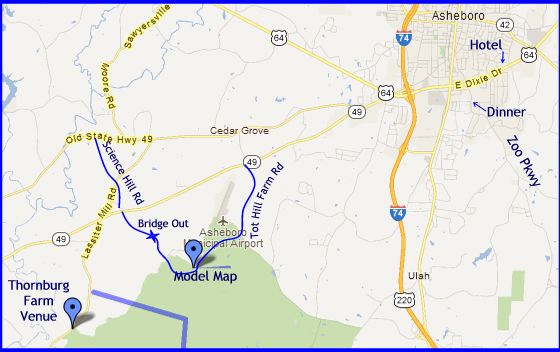
Directions
Model Event The Model event is located at the Tot Hill Trail Head at 3100 Tot Hill Farm Rd, Asheboro NC. It is open from Friday at Noon until 5:00pm. Maps are available for $5.00 at the Holiday Inn Express check-in desk. Just sign for the map and then pay when you pick up your registration packet. The controls will be picked up at 5:00pm. From Asheboro head west/south on NC-49 (not old 49) then turn left at the Stone Yard onto Tot Hill Farm Rd, and follow it around past the stop sign. The Forest Service sign will indicate the trail head. A start and clear box will be located at the start, and you can download and print your results at Registration Friday evening or Saturday morning. There is no water out on the course.
Thornburg Historic Farm - Event Venue 3955 Lassiter Mill Rd, Asheboro, NC
From US-64 head west/south on NC-49 for 5.6 mi at the first yellow “Road Crossing” sign turn Right on Science Hill Rd. In one block turn Left on Lassiter Mill Rd. for 2.5 mi and Thornburg Farm is on your left with Forest Service signs alerting you to the turn. (Note: Lassiter Mill Rd. is grade separated from NC-49, so you must turn right on Science Hill Rd and then left on Lassiter Mill.)
Parking: Follow directions to parking. We will be parking in the farmer’s field across the road from the Thornburg Farm entrance. If the parking area is full you may park on the side of the road. If you are parking on Lassiter Mill Rd. only park on the East side of the road and be sure your car is completely off the pavement. There is not much traffic on Lassiter Mill Rd, but please be careful crossing the road.
Dinner 6:00 pm Something Different Restaurant, 1512 F-H Zoo Pkwy, Asheboro, NC. We have a room reserved for our group. There will be a buffet. From the Holiday Inn head west on US-64 for about one mile. Turn left following signs to the Zoo onto Zoo Parkway. The restaurant is in the first shopping center on your right.
Mapping Characteristics and Course Setters Notes
Birkhead Wilderness Area is rolling ridge and valley with a mature deciduous forest. The maximum rise is 75 m. The woods are mostly open and runnable. There are small rock features throughout the map, and a few large rock features. There are small streams and very few trails.
Map Standard, Scale, and Printing
The contour interval for both days is 3 meters. The “Drafting Scale” is 1:10,000.
- The maps are printed at a scale of 1:10,000 except
- Saturday, the maps for Blue and Red are printed at a scale of 1:15,000
- Both days White is printed at 1:5,000
- The maps are printed on 8.5" x 11" paper except
- Sunday the maps are 8.5”x14” for Blue, and Red.
- Maps are sealed in clear plastic.
Private Land
The private land is marked on the map with an olive line with tags pointing toward the public land. Restricted areas are marked with vertical purple lines. You must stay out of those areas. There are no marking in the forest indicating private land other than the “No Trespassing” signs. On Sunday there are sections along both the east and west edges of the national forest where the restricted symbol does not include all the private land. In these two cases we have permission to use that land, and since competitors may need to use these areas they are not indicated with the restricted area symbol.
Knolls and Rootstocks
Some time ago there was a major storm and many trees were blown down. They have mostly rotted down so as not to be a running impediment. They have left knolls and almost knolls where their roots are disappearing.
BOK uses a green “T” as the symbol for large rootstocks that have significant trunks. The symbol is oriented showing the direction the trunk is pointing, the top line of the “T” representing the roots and the vertical line the trunk. That said, the rootstock mapping is somewhat dependent on how many are in the area with smaller ones being mapped in areas with fewer features.
It is sometimes difficult to distinguish between a rootstock and knoll. With the roots and trunk gone it is clearly a knoll, however there are sections where most of the roots and trunk are gone, but not all, so it was a judgement call as to how to map it.
There are some sections near the finish on Saturday where virtually every tree was blown over in a storm about 20 years ago. The knolls/rootstocks are covering the area. These were not mapped in the original map, and we did our best to map them in the areas where controls are placed, however don’t be surprised if you come into an area that has no knolls mapped and it is covered with knolls.
Old Roads & Man Made Objects
There was lots of farming, logging and prospecting activity in these woods many years ago and the remains can be found throughout the forest. (Prospecting for gold continues, and we have met several people bringing flecks of gold out of the rivers.) Old roads are visible or nearly so in many places. Some are mapped if they are distinct enough and have significant length. You will come upon short sections of unmapped old roads. In some cases all that is left is an erosion gully running diagonally down the side of a slope.
There are some old piles of discarded fence wire which are mapped using a black “X”, and there is some standing barbed wire fences. Most are mapped and we have flagged some of it.
There are forest service boundary posts in seemingly random places in the middle of the forest which are generally not mapped unless they are boundaries for private lane.
Trails
Because there are so few trails we had to flag temporary trails for White and Yellow. The ribbons we set out are marked “BOK”. Ribboned trails are not required routes, they fill in the trail system for white and yellow courses. Usually there is no visible trail on the ground. Some indistinct old roads have ribbons on them, in that case they will be shown as purple on the map.
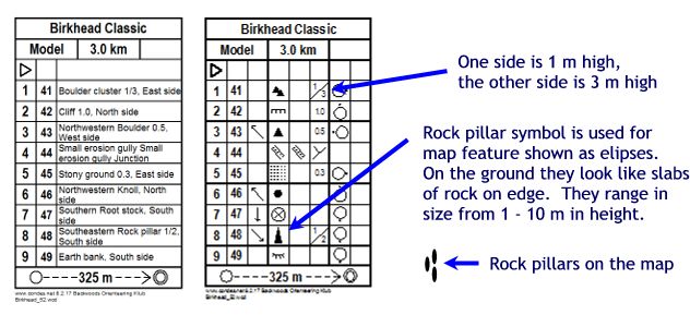
Rock Features
In areas without much rock, a boulder less than 1 m may be mapped as a boulder, and in areas of more rock several small “boulders” could be mapped as “stony ground”. The “stony ground” symbol #210 consisting of small .2 mm dots are used to map rocky areas with rocks that are clearly visible from a distance and generally less than one meter. The dots do not indicate the individual rocks in the group. The stony ground is not small 6-10cm rocks on the ground. The size will be indicated on the control description when used as a control site.
The larger dots .4mm - .6mm symbols #206 and #207 are used for the larger boulders that are individuality mapped.
We have some distinct bolder slabs that look like large headstones. They range in size with most of them from 1-3m with some as large as 8m in height. The elongated “rock pillars” symbol #202 was used for these distinctly shaped rocks. Don’t expect all of the “rock pillars” to be tall. When one of these features is used for a control we mention the size in the control description.

Vegetation
The dark green is reasonably accurate the light green is more subjective and won’t be particularly useful for navigating.
The Birkhead Wilderness is part of the National Forest System.
The Uwharrie National Forest was first purchased by the federal government in 1931 during the Great Depression. In 1961, President John F. Kennedy proclaimed these federal lands in Montgomery, Randolph, and Davidson Counties the Uwharrie National Forest. It is one of the most recently formed in the National Forest System. Though small, at only 50,645 acres, the Uwharrie provides a variety of recreation opportunities and natural resources, including clean rivers and streams, diverse vegetation for scenery, wildlife habitat and wood products.
The U.S. Department of Agriculture (USDA), Forest Service prohibits discrimination in its programs on the basis of race, color, national origin, sex, religion, age, disability, political beliefs, sexual orientation, or marital or family status. To file a complaint of discrimination, write USDA, Director, Office of Civil Rights, Room 326-W, Whitten Building, 1400 Independence Avenue, SW Washington, DC 20250-9410 or call (202) 720-5964 (voice and TDD). USDA is an equal opportunity provider and employer.
Refreshments
Plain water is provided on the courses. All the water is located at controls. There is one water control for at least every 2.5 km of each course. Use the cups, it is against USOF rules to drink from the water jugs. Water and Vitalyte (aka Gookenaid) will be available at the finish and at Thornburg Farm. We will also have some fruit and snacks.
There will be an independent vendor’s hot dog stand selling hot dogs and soft drinks.
Courses:
Saturday: 15 Minute van ride leaving from Thornburg Farm, and 1.3 km walk to the start from the van drop off area. The finish is near the start and the van will transport you back to Thornburg Farm.
Course Length Climb Map Scale
White 2.1 km 54 m 1:5,000
Yellow 2.8 km 69 m 1:10,000
Orange 3.9 km 111 m 1:10,000
Brown 3.9 km 99 m 1:10,000
Green 5.7 km 138 m 1:10,000
Red 8.1 km 246 m 1:15,000
Blue 10.3 km 273 m 1:15,000
Sunday: The start is a 950 m walk from the Thornburg Parking area. The finish is adjacent to the parking area.
Course Length Climb Map Scale
White 2 km 69 m 1:5,000
Yellow 3.1 km 84 m 1:10,000
Orange 4.0 km 144 m 1:10,000
Brown 3.9 km 141 m 1:10,000
Green 5.9 km 198 m 1:10,000
Red 8.0 km 174 m 1:10,000
Blue 10.2 km 306 m 1:10,000
Maximum Time on the course is 3 Hours.
If your maximum time has elapsed, you must report to the finish.
Control Equipment
We are utilizing SportIdent version BSF8. If your control does not beep or flash the confirmation LED, you must punch your map with the attached paper punch. Paper punches from malfunctioning controls are required and will be verified. All controls are mounted on poles with the SI-box on top. The punches are attached to the controls with cord. Where two SI-boxes are at the same location they will both have control flags with the same number - you can punch either control.
Warnings
Trails: There are very few trails. The advanced courses have almost no trails. To complete the trail system for the White & Yellow Courses we created routes in the woods flagged with orange ribbons marked “BOK” and the date. These routes are marked on the map with purple dashes and dots. There are other, non-orienteering related, ribbons out there, so be careful.
Map Edge: The courses go close to the edge of the map and there is no natural catch feature to keep you from going off the map.
Safety bearing: West. The west edge of the map is bounded by a few hundred meters of private land and then Lassater Mill Road. The map’s eastern edge is about in the middle of the forest. It is a long way to a road if you go east. There is no catch feature along the east of the map. If you are totally lost then walk West. You will probably come out on someone’s private property before reaching the road. If they have a phone then you can call the BOK emergency number, 919-610-1788 and someone will pick you up.
Barbed Wire: There are some piles of barbed wire and some old standing fence in the forest. Most is mapped, be careful.
Ticks: We have not seen any ticks while setting the courses, however if it warms up they may come out. We recommend using tick repellent. We have found “Sawyer Permethrin” clothing spray to be very effective at keeping ticks off. You apply it to your clothes (waist down) and let it dry before putting your clothes on. It is available at most camping, outdoor and “big box” stores.
Stump holes: When a soft wood tree dies and the root rots away you are left with a “stump hole” Your foot can sink down 0.3 m. Don’t let them trip you up.
Vines: We have a few of the thorny “wait a minute” vines, however we have more “wait a second” vines. They don’t have thorns but they tend to run along the ground and have loops that can catch your foot and trip you up.
Close Controls: On the White course there are some controls closer than 75 m in order to have controls at the trail junctions. USOF rules require that controls on similar features are a minimum of 100 m apart and on different features 75 m apart. There are many that just meet this standard.
Be sure to check your control number! If you do punch a wrong control, no problem, just find the correct control and punch it. Extra controls do not count against you, however all your required controls must be in order. Extra controls within the sequence of controls don't count.
Whistle: All competitors are requested to carry a whistle or signaling device. If you are hurt, blow the whistle in groups of three. Whistles will be on sale at Registration for $1.
Don't cross deep water: None of the courses cross deep creeks. Uncrossable sections of creeks are marked with solid black lines. The water is cold! Do not try to cross streams if the water is over your knees.
If you are lost: If you are lost and find a trail – stay on the trail. If you find a control – stay with the control. We will search for you by first running the trails, and picking up the controls. On both days the emergency bearing is West. If you are totally lost then walk West. You will probably come out on someone’s private property before reaching the road.
Shooting: There are private shooting ranges on the private property near Thornburg Farm. We have heard them shooting some semi automatic large caliber guns. On the bright side, hunting season is taking a break, so there shouldn’t be any shooting in the forest.
BOK emergency number: The BOK Emergency number 919-610-1788.
Medical
We will have an emergency medical team at the park. They will be stationed outside near the Finish for both days to help with minor injuries. 911 service works for a serious emergency. The Randolph County Hospital is at 364 White Oak Street Asheboro, NC 27204. (336) 625-5151 BOK emergency number: The BOK Emergency number 919-610-1788.
Start
Saturday: Vans are on a 15 minute pick up schedule, then it is a 15 minute ride to the drop off point and 1.3 km walk to start.
Sunday: 950 m walk to the start.
Start Procedure
- You must clear your SportIdent finger stick (SI-Card) prior to the start. Stick it into a control box marked “Clear” until the box beeps and blinks.
- If you have a GPS device with a display you should go to the start line to have your GPS display taped. (see below)
- Put your jacket in the bag if you want it brought to the finish.
- 3 minutes prior to your time you will be called up and confirmed on the start list. At the whistle you will move to the control description table.
- 2 minutes prior to your time you can get a copy of your control descriptions. There will be tape available if you need it. Control descriptions will also be printed on the map.
- At the whistle 1 minute prior to your time you move to the map pick-up line.
- At the map pick-up line you will see bags of maps clearly identified by color. Find the bag for your course, pick out a map – face down - put your name & or number on the back
- Show the front of the map to the volunteer to check that you have the right course.
- You must punch the CHECK box the volunteer is holding after your map is checked.. This is the backup list for all starters and confirms that your si-card is ready to start.
- When the whistle blows you must punch the Start control box before looking at your map. Your course time starts when you punch the Start Box.
- You must proceed down the trail to the “Start Triangle” location which is marked with a triangle on the ground. All courses start at the same location.
Finish
You must punch the finish control box. Then stay in line until you download and receive your splits. Your split time will indicate if you have finished your course successfully and will include the time you punched each control. If everyone has started you may keep your map, otherwise maps will be kept by the finish crew and returned after the last start. Jackets will be brought from the start to the finish where you can pick them up.
Saturday: After download walk back to the van pick-up point on the main road and the van will transport you back to Thornburg Farm. Maps will be returned at Thornburg Farm.
Sunday: You will be at the results posting area after you finish.
Control Descriptions
Control descriptions will be printed on the face side of your maps. Descriptions for the White and Yellow courses will be given as text, and the rest, as international pictorial descriptions.
The descriptions will not be available in your event packets. The descriptions for your course will be available for the minute after the call-up line. The size of the control description box is 6 mm, i.e. the description sheet given to you at the start is 48 mm (2") wide. If you need an extra minute to attach your control the meet official will allow you to start attaching your control description earlier, just ask.
Use of GPS Equipment:
GPS units with a visible display may not be used by competitors in Championship Classes. GPS recording only devices are permitted.
If you wish to carry a GPS device with a display to record your track, you should declare it at the start and we will cover the display with a tape that only sticks to itself and can not be removed without destroying the tape. It will not stick to your watch. Show the intact tape at the finish and you will not be disqualified.
Spectator Opportunities
There are no spectator opportunities other than watching the run-in at the finish.
Results
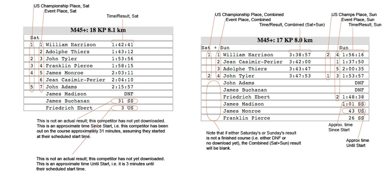
Results will be available on our local wifi network for your smart phone or tablet. There will also be monitors, located in the historic and rustic chicken shed, displaying the results. Below the compact display the splits will be listed. Pictured here is the Legend for the results display. Note that these results will be updating every minute, and you can see how long someone has been out (assuming they started at their scheduled time) and how much time until their scheduled start.
.
Complaints and Jury
The jury for the event will consist of three people:. Complaints and protests should be directed to Event Director, Joseph Huberman within one hour of the posting of the results or the close of finish whichever is later.
Awards
Awards are determined by the combined times of both events and must be picked up at the awards ceremony. If you are leaving early you should designate someone to pick your award up for you. In some cases it may be possible to pick your award up at registration if you need to leave before the awards ceremony.
The top three US Champ eligible Competitors will receive OUSA Championship Medals
Competitors who are in the top three places and not eligible for US champion awards or are not running in a championship class will receive BOK medals.
Child Care
Child care will be in the child care tent near the finish on both days.
Camping and Toilets
Primitive camping is permitted without permit or fee in the Uwharrie National Forest and Birkhead Wilderness Area. However, the only forest that is not embargoed on Friday is the Model Map area, accessible from the Tot Hill trail head. 3100 Tot Hill Farm Rd, Asheboro NC
After the close of the finish Saturday you can primitive camp on the southern section of Saturday’s map. You must stay south of the Saturday finish. In addition you must stay at least 200 feet from all streams, creeks, roads and wildlife fields. Please don’t build fires and of course pack out all your trash and leave no trace.
Toilets: We will have two toilets at the Thornburg Farm venue for both Saturday and Sunday, and one toilet at the finish and about 200 m from the start on Saturday.
Credits
Event Director: Joseph Huberman
Registration: Ruth Bromer, Carlie Huberman, Lori Huberman
Course Design: Joseph Huberman, Ruth Bromer
Course Consultant: Scott Donald
Child Care: Bryan Gaston
Medical: DaiWai Olson
Photography: Carlie Huberman
Vetting: Vladimir Stemkovski, Mihai Ibanescu, Ken. Hanson, Terese Camp, Artem Kazantsev, Josef Trzicky, Joseph Huberman, Ruth Bromer
Sector Setting: Vladimir Stemkovski, Tatyana Stemkovski, Ian Shields, Bill Ebenstein, Al Geiger, Holly Kuestner, Harold Meder
Control Pickup: Sector Volunteers assisted by Brendan Shields, Ian Smith, Ali Crocker
Starts: Ian Shields, Dick Stuart, Matt Harmody, Pat McQuaid
Finish: Mihai Ibanescu, Lew Stookey, Artem Kazentsev, Bill Ebenstein, Diana Diaz, Paul Bradley, Alan McNeely
Results: Ken. Hanson
Shirts: Ruth Bromer, Joseph Huberman
Awards: Ruth Bromer
IT: Mihai Ibanescu, Ken. Hanson, Ruth Bromer, Artem Kazantsev
Field Checking: Josef Trzicky in 2008-2011
Drafting: Jan Csibrei
Map Updates: Vladimir Stemkovski
Control Managing: Ken. Hanson, Terese Camp